Aerial photographic and satellite image interpretation

Last updated
Photo interpretation at the U.S. National Photographic Interpretation Center during the Cuban Missile Crisis. Photo interpretation.jpg
Photo interpretation at the U.S. National Photographic Interpretation Center during the Cuban Missile Crisis.

Aerial photographic and satellite image interpretation, or just image interpretation when in context, is the act of examining photographic images, particularly airborne and spaceborne, to identify objects and judging their significance. [1] This is commonly used in military aerial reconnaissance, using photographs taken from reconnaissance aircraft and reconnaissance satellites.

Contents

The principles of image interpretation have been developed empirically for more than 150 years. The most basic are the elements of image interpretation: location, size, shape, shadow, tone/color, texture, pattern, height/depth and site/situation/association. They are routinely used when interpreting aerial photos and analyzing photo-like images. An experienced image interpreter uses many of these elements intuitively. However, a beginner may not only have to consciously evaluate an unknown object according to these elements, but also analyze each element's significance in relation to the image's other objects and phenomena.

Angle of view

Vertical imagery and photographs

Vertical aerial photographs represent more than 95% of all captured aerial images. [2] The principles of capturing vertical photographs are shown in Figure 2. [3] [4] Two major axes which originate from the camera lens are included. [3] One is the vertical axis which is always at 90° to the study area. [3] Another one is the camera axis which changes with the angle of the camera. [3] To capture a vertical aerial photograph, both of these axes must be in the same position. [3] The vertical pictures are captured by the camera which is above the object being photographed without any tilting or deviation of the camera axis. [5] Areas in a vertical aerial photograph often have a consistent size. [4]

Figure 2: The principle of vertical aerial photography. Vertical photography.jpg
Figure 2: The principle of vertical aerial photography.

Oblique aerial photographs

Oblique aerial photographs are captured when the cameras are set at specific angles to the land. [5] It is a very helpful enhancement or addition to the traditional vertical image. [2] It allows the vision to pass through a relatively high proportion of the plant cover and leaves of trees. [2] Oblique aerial photographs can be classified into two types.

Low oblique

Low oblique aerial photographs are generated when the camera axis has a 15–30° angle difference from the vertical axis, shown in figure 3. [3] The horizon, the dividing border between planet and atmosphere from a viewing angle, [6] is unobservable in a low oblique aerial photograph. [5] The length between two points is unable to be calculated and is not accurate because a low oblique image does not have a scale. The orientation of objects is also inaccurate. [5] Low oblique photographs can be used as a reference before site investigation because they give updated details of local places. [3] [4]

Figure 3: The principle of low oblique aerial photography Low Oblique 2.jpg
Figure 3: The principle of low oblique aerial photography

High oblique

High oblique aerial photographs are generated when the camera axis has a 60° angle difference from the vertical axis, shown in figure 4. [3] In this case, the horizon is observable. [5] This type of photograph captures a fairly sizable region. [5] As in a low oblique photograph, the length between two points and the orientation of objects are inaccurate. [5] High oblique aerial photographs are widely used in assisting field investigation because the line of sight shown is more similar to humans. [3] Features and structures can be easily recognized. [4] However, landscapes, buildings and hillslopes that are blocked by the mountainous areas are not visible. [4]

Figure 4: The principle of high oblique aerial photography. High Oblique.jpg
Figure 4: The principle of high oblique aerial photography.

Color and false color

Black and white

Black and white aerial photographs are frequently used for drawing maps, such as topographic maps. [5] Topographic maps are precise, in-depth descriptions of the terrain characteristics found in the areas or regions. [7] Black and white aerial photography is capable of producing good-quality images under poor weather conditions, such as foggy and misty air. [2]

Color

Color aerial photographs preserve and capture the colors of the original objects through the numerous layers inside the film. [8] Color photographs can be used to distinguish different kinds of soils, rocks, and deposits that are located above the rock layers, and some contaminated water sources. [5] The degradation of trees driven by the insects can also be identified using color aerial photos. [5] It can assist in locating storage of materials in the natural environment, such as trees, wild animals and oil. [4]

Color infrared

Color infrared aerial photographs are captured using false color film which changes the original color of different features into "false color". [2] [5] For example, grasslands and forests which are green in nature have a red color. [2] But some artificial objects which are covered in green may have a blue color. [2] This phenomenon is due to the fact that plants reflect more infrared radiation (IR) than man-made objects. [2] Dense vegetation cover may give a more intense red color than that of sparse vegetation cover. This helps in determining whether the trees are healthy or not. [5] It also gives evidence for the growth rate of plants. [5] It is helpful when identifying the boundary between land and ocean or lakes because the ocean does not reflect the IR. [2]

Altitudes

High-altitude

High-altitude aerial photographs are taken when the plane is flying in the altitude range of 10,000 to 25,000 feet. [2] The advantage of high-altitude aerial photography is that it can record the information of a larger area by taking one photograph only. [5] However, high-altitude photographs cannot show as many details as low-altitude photographs since some objects, such as buildings, roads, and infrastructures, are of a very tiny in size in the image. [5]

Low-altitude

Low-altitude aerial photographs are taken when the plane is flying at an altitude of less than 10,000 feet. [2] The objects in the photograph are of a larger in size and contain more details compared with those in high-altitude photographs. [5] Due to this advantage, a routine collection of low-altitude photographs has been conducted every six months since 1985. [2]

Scale

Figure 5: The principle of scale of aerial photographs Sketch diagram of remote sensing terminology 4 1 2.jpg
Figure 5: The principle of scale of aerial photographs

The scale of aerial photography or satellite imagery is the value calculated when the elevation difference between the photo film and the camera lens is divided by the difference between the camera lens and the terrain surface. [4] It can also be measured by dividing the measured length of two locations in the photo by the length of those locations in reality. [4] [3] In figure 5, several related terms and symbols are shown. Focal length (f) refers to the elevation difference between the film and the lens. [2] [4] H is the elevation difference between the lens and the sea level, which is the average level of the water surface. [2] [4] h is the elevation difference between the terrain surface and the sea level. [2] [4] S is the scale of aerial photographs. [2] [4] is the formula for scale measurement. [2] [4] This measurement controls the amount and types of buildings observed in the photographs, the occurrence of some specific characteristics, and the certainty of the measurements. [3] For example, a large-scale photograph usually gives a more accurate measurement of distance compared with a small-scale photograph. 1:6000 to 1:10000 is the best range of scale for landslip research and geological mapping for ground assessment. [2]

Large-scale imagery

Large-scale aerial photographs are those taken at a scale of 1:500 to 1:1000. [9] This type of photograph is best suited for local site investigations. [9] It looks like a zoomed-in map.

Small-scale imagery

Small-scale aerial photographs are those taken at a scale of 1:5000 to 1:20000. [9] It is more suitable for provincial or large area research. [9]

Interpreting imagery

Elements to interpret

Size

The size of an object is one of the most distinguishing characteristics and one of the most important elements of interpretation. Most commonly, length, width and perimeter are measured. To be able to do this successfully, it is necessary to know the scale of the photo. Measuring the size of an unknown object allows the interpreter to rule out possible alternatives. It has proved to be helpful to measure the size of a few well-known objects to give a comparison to the unknown-object. For example, field dimensions of major sports like soccer, football, and baseball are standard throughout the world. If objects like this are visible in the image, it is possible to determine the size of the unknown object by simply comparing the two.

Shape

There is an infinite number of uniquely shaped natural and man-made objects in the world. A few examples of shape are the triangular shape of modern jet aircraft and the shape of a common single-family dwelling. Humans have modified the landscape in very interesting ways that has given shape to many objects, but nature also shapes the landscape in its own ways. In general, straight, recti-linear features in the environment are of human origin. Nature produces more subtle shapes.

Shadow

Virtually all remotely sensed data are collected within 2 hours of solar noon to avoid extended shadows in the image or photo. This is because shadows can obscure other objects that could otherwise be identified. On the other hand, the shadow cast by an object act as a key for the identification of the object as the length of the shadow will be used to estimate the height of the object which is vital for the recognition of the object. Take for example, the Washington Monument in Washington D.C. While viewing this from above, it can be difficult to discern the shape of the monument, but with a shadow cast, this process becomes much easier. It is a good practice to orient the photos so that the shadows are falling towards the interpreter. A pseudoscopic illusion can be produced if the shadow is oriented away from the observer. This happens when low points appear high and high points appear low.

Tone and color

Real-world materials like vegetation, water and bare soil reflect different proportions of energy in the blue, green, red, and infrared portions of the electro-magnetic spectrum. An interpreter can document the amount of energy reflected from each at specific wavelengths to create a spectral signature. These signatures can help to understand why certain objects appear as they do on black and white or color imagery. These shades of gray are referred to as tone. The darker an object appears, the less light it reflects. Color imagery is often preferred because, as opposed to shades of gray, humans can detect thousands of different colors. Color aids in the process of photo interpretation.

Texture

This is defined as the “characteristic placement and arrangement of repetitions of tone or color in an image.” Adjectives often used to describe texture are smooth (uniform, homogeneous), intermediate, and rough (coarse, heterogeneous). It is important to remember that texture is a product of scale. On a large scale depiction, objects could appear to have an intermediate texture. But, as the scale becomes smaller, the texture could appear to be more uniform, or smooth. A few examples of texture could be the “smoothness” of a paved road, or the “coarseness” a pine forest.

Pattern

Pattern is the spatial arrangement of objects in the landscape. The objects may be arranged randomly or systematically. They can be natural, as with a drainage pattern of a river, or man-made, as with the squares formed from the United States Public Land Survey System. Typical adjectives used in describing pattern are: random, systematic, circular, oval, linear, rectangular, and curvilinear to name a few.

Height and depth

Height and depth, also known as “elevation” and “bathymetry”, is one of the most diagnostic elements of image interpretation. This is because any object, such as a building or an electric pole that rises above the local landscape will exhibit some sort of radial relief. Also, objects that exhibit this relief will cast a shadow that can also provide information as to its height or elevation. A good example of this would be buildings of any major city.

Other factors to consider during interpretation

Photograph Metadata

An aerial photograph marks different data and information about the covered area and the airplane's position and condition. [2] These details are measured and noted by the data panel which includes different devices and instruments for the specific measurements. [2] Figure 8 shows the general format of a vertical aerial photograph.

Figure 8: Details on an aerial photograph. It includes the focal length, flying height, location, photo number, recorded time and date, etc. Format of aerial photograph 2.png
Figure 8: Details on an aerial photograph. It includes the focal length, flying height, location, photo number, recorded time and date, etc.

Location

There are two primary methods to obtain a precise location in the form of coordinates. 1) survey in the field by using traditional surveying techniques or global positioning system instruments
2) collect remotely sensed data of the object, rectify the image and then extract the desired coordinate information. Most scientists who choose option 1 now use relatively inexpensive GPS instruments in the field to obtain the desired location of an object. If option 2 is chosen, most aircraft used to collect the remotely sensed data have a GPS receiver.

Site background and association

Site has unique physical characteristics which might include elevation, slope, and type of surface cover (e.g., grass, forest, water, bare soil). Site can also have socioeconomic characteristics such as the value of land or the closeness to water. Situation refers to how the objects in the photo or image are organized and “situated” in respect to each other. Most power plants have materials and building associated in a fairly predictable manner. Association refers to the fact that when you find a certain activity within a photo or image, you usually encounter related or “associated” features or activities. Site, situation, and association are rarely used independent of each other when analyzing an image. An example of this would be a large shopping mall. Usually there are multiple large buildings, massive parking lots, and it is usually located near a major road or intersection.

Aerial photographs overlap

Overlapping of aerial photos means that around 60% of the covered area of every aerial image overlays that of the one before it. [2] Every object along the flying path can be observed twice at a minimum. [2] The purpose of overlapping the aerial photography is to generate the 3D topography or relief when using a stereoscope for interpretation. [2] The stereoscope is an instrument used to see the 3D overlapping aerial images. [2]

Reaching the requirements of the two chosen, overlapping images is simple. The principal points (central point of the image in geometry) of the two photos must be in different locations on the terrain. [2] Another restriction is that the scale of the images must be the same. [2] The flying routes of the planes and the time of day are not restricted. [2]

Figure 9: This diagram describes the principle of the overlapping of two covered areas along a single flying path. Overlapping principle of aerial images.jpg
Figure 9: This diagram describes the principle of the overlapping of two covered areas along a single flying path.

Aerial photo-geometry orientation

The preferred orientation of an aerial photograph is closely related to the position of the Sun and the shadow element. [2] In the Northern Hemisphere, the south direction is always the position of the sun. [2] Therefore, shadows are usually formed on the north side. [2] This then affects the shadow element in aerial photographs. For example, if the plane is flying from North to South, the sunlight is also coming North and the shadows that show the shapes of objects can be clearly observed in aerial photographs. [2] If the plane is flying from South to North, shadows will not be clearly observed. [2] For photo interpretation, it is preferred that the image is taken so that the shadows can be clearly observed [2] as shadows can highlight the relief of the topography. [2] This orientation of the image also helps geologists link the 3D pictures to what they observe. [2]

Figure 10: This diagram shows the position of the Sun (south). When the sunlight is from the south direction, the shadow is usually in the north direction. Therefore, the airplane which flies from north to south can clearly record the shadow elements of the objects. Sun position and shadow 3.png
Figure 10: This diagram shows the position of the Sun (south). When the sunlight is from the south direction, the shadow is usually in the north direction. Therefore, the airplane which flies from north to south can clearly record the shadow elements of the objects.

Displacement and distortion

Distortion and displacement are two common phenomena observed on an aerial photograph.

Displacement

Displacement is a result of varying topographic relief within a covered area. [4] A datum plane, which refers to the average sea level, is essential in the displacement phenomenon. [4] For a location which has an elevation higher than that of the datum plane, the original position will move away from the central point of the image. [4] For a location which has an elevation lower than that of the datum plane, the original position will move closer to the central point of the image. [4]

Figure 11. This diagram shows an example of displacement. A is the location that is lower than the datum plane. It moves inward to the central point. B is the location that is higher than the datum plane. It moves away from the central point. These locations are displaced in the opposite direction. Displacement of aerial photograph.png
Figure 11. This diagram shows an example of displacement. A is the location that is lower than the datum plane. It moves inward to the central point. B is the location that is higher than the datum plane. It moves away from the central point. These locations are displaced in the opposite direction.

Distortion

Distortion refers to any change in an object's or region's location on an aerial photo that modifies its original features and shapes. [2] It usually appears near the picture's border. [2] There are two causes of distortion. The first one is the tilt and tip of a plane. [4] When the aircraft is rising or descending it produces a tip. [4] When the aircraft leans in a particular direction during the aerial survey, it produces a tilt. [4] The tilt axis is perpendicular to the tip axis. [4] The second reason is the processing of photographs. [4] This is a process used to modify the exposed photo film to generate an aerial photograph. [10] When the moistened film dries, it expands through one orientation and contracts through the other orientation. [4] Only a small amount of distortion is caused by this. [4]

Pre-digital interpretation methods using a mirror stereoscope

  1. Choose two (2) aerial photos which are taken one after the other and make sure there is at least 60% superimposition. [2]
  2. Make sure they are placed in the same orientation and the northern part of the aerial photograph as well as the generated shadows should be placed towards the interpreter. [2]
  3. Make sure the distance between the pair of eyepieces, a lens used in the stereoscope for observation, fits the distance between the eyes. [2]
  4. Put both forefingers on the same, easily identified object in each of the photos. [2]
  5. Slowly drag the photos until the two objects are overlapped under the stereoscope. [2]
  6. The overlapped areas then appear 3D under the stereoscope. [2]
    Figure 12: An example of a mirror stereoscope. Ja i stereoskop.JPG
    Figure 12: An example of a mirror stereoscope.


See also

Related Research Articles

<span class="mw-page-title-main">Stereoscopy</span> Technique for creating or enhancing the illusion of depth in an image

Stereoscopy is a technique for creating or enhancing the illusion of depth in an image by means of stereopsis for binocular vision. The word stereoscopy derives from Greek στερεός (stereos) 'firm, solid', and σκοπέω (skopeō) 'to look, to see'. Any stereoscopic image is called a stereogram. Originally, stereogram referred to a pair of stereo images which could be viewed using a stereoscope.

<span class="mw-page-title-main">3D projection</span> Design technique

A 3D projection is a design technique used to display a three-dimensional (3D) object on a two-dimensional (2D) surface. These projections rely on visual perspective and aspect analysis to project a complex object for viewing capability on a simpler plane.

<span class="mw-page-title-main">Aerial photography</span> Taking images of the ground from the air

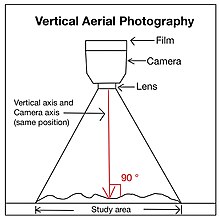
Aerial photography is the taking of photographs from an aircraft or other airborne platforms. When taking motion pictures, it is also known as aerial videography.

<span class="mw-page-title-main">Photogrammetry</span> Taking measurements using photography

Photogrammetry is the science and technology of obtaining reliable information about physical objects and the environment through the process of recording, measuring and interpreting photographic images and patterns of electromagnetic radiant imagery and other phenomena.

<span class="mw-page-title-main">Orthophoto</span> Geometrically corrected aerial photograph

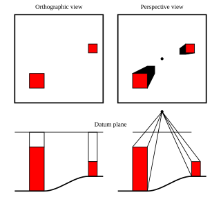
An orthophoto, orthophotograph, orthoimage or orthoimagery is an aerial photograph or satellite imagery geometrically corrected ("orthorectified") such that the scale is uniform: the photo or image follows a given map projection. Unlike an uncorrected aerial photograph, an orthophoto can be used to measure true distances, because it is an accurate representation of the Earth's surface, having been adjusted for topographic relief, lens distortion, and camera tilt.

Aerial archaeology is the study of archaeological remains by examining them from a higher altitude. In present day, this is usually achieved by satellite images or through the use of drones.

<span class="mw-page-title-main">Aerial survey</span> Method of collecting geophysical data from high altitude aircraft

Aerial survey is a method of collecting geomatics or other imagery by using airplanes, helicopters, UAVs, balloons or other aerial methods. Typical types of data collected include aerial photography, Lidar, remote sensing and also geophysical data (such as aeromagnetic surveys and gravity. It can also refer to the chart or map made by analysing a region from the air. Aerial survey should be distinguished from satellite imagery technologies because of its better resolution, quality and atmospheric conditions. Today, aerial survey is sometimes recognized as a synonym for aerophotogrammetry, part of photogrammetry where the camera is placed in the air. Measurements on aerial images are provided by photogrammetric technologies and methods.

<span class="mw-page-title-main">Composition (visual arts)</span> Placement or arrangement of visual elements or ingredients in a work of art

The term composition means "putting together". It can be thought of as the organization of the elements of art according to the principles of art. Composition can apply to any work of art, from music through writing and into photography, that is arranged using conscious thought.

<span class="mw-page-title-main">Terrain cartography</span> Representation of surface shape on maps

Terrain cartography or relief mapping is the depiction of the shape of the surface of the Earth on a map, using one or more of several techniques that have been developed. Terrain or relief is an essential aspect of physical geography, and as such its portrayal presents a central problem in cartographic design, and more recently geographic information systems and geovisualization.

<span class="mw-page-title-main">Stereoplotter</span>

A stereoplotter uses stereo photographs to determine elevations. It has been the primary method to plot contour lines on topographic maps since the 1930s. Although the specific devices have advanced technologically, they are all based on the apparent change in position of a feature in the two stereo photographs.

<span class="mw-page-title-main">3D reconstruction</span> Process of capturing the shape and appearance of real objects

In computer vision and computer graphics, 3D reconstruction is the process of capturing the shape and appearance of real objects. This process can be accomplished either by active or passive methods. If the model is allowed to change its shape in time, this is referred to as non-rigid or spatio-temporal reconstruction.

<span class="mw-page-title-main">Architectural drawing</span> Technical drawing of a building (or building project)

An architectural drawing or architect's drawing is a technical drawing of a building that falls within the definition of architecture. Architectural drawings are used by architects and others for a number of purposes: to develop a design idea into a coherent proposal, to communicate ideas and concepts, to convince clients of the merits of a design, to assist a building contractor to construct it based on design intent, as a record of the design and planned development, or to make a record of a building that already exists.

<span class="mw-page-title-main">PhotoModeler</span> Software application

PhotoModeler is a software application that performs image-based modeling and close range photogrammetry – producing 3D models and measurements from photography. The software is used for close-range, aerial and uav photogrammetry.

<span class="mw-page-title-main">Digital outcrop model</span> Digital 3D representation of the outcrop surface

A digital outcrop model (DOM), also called a virtual outcrop model, is a digital 3D representation of the outcrop surface, mostly in a form of textured polygon mesh.

<span class="mw-page-title-main">Strip photography</span> Type of photographic technique

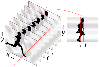
Strip photography, or slit photography, is a photographic technique of capturing a two-dimensional image as a sequence of one-dimensional images over time, in contrast to a normal photo which is a single two-dimensional image at one point in time. A moving scene is recorded, over a period of time, using a camera that observes a narrow strip rather than the full field. If the subject is moving through this observed strip at constant speed, they will appear in the finished photo as a visible object. Stationary objects, like the background, will be the same the whole way across the photo and appear as stripes along the time axis; see examples on this page.

Aerial reconnaissance using heavier-than-air machines was an entirely new science that had to be improvised step-by-step. Early operations were low-level flights with the pilot often dismounting from the plane to report verbally to the nearest officers. Photographic support was urgently developed, initially requiring a full-time photographer on board to handle the heavy, awkward equipment. The interpreting of aerial images was an important new speciality, essential for accurate mapping. By 1915, air-to-ground radio was in use for reconnaissance pilots.

<span class="mw-page-title-main">Aerial reconnaissance in World War II</span>

A transformational growth in aerial reconnaissance occurred in the years 1939–45, especially in Britain and then in the United States. It was an expansion determined mostly by trial and error, represented mostly by new tactics, new procedures, and new technology, though rarely by specialized aircraft types. The mission type branched out into many sub-types, including new electronic forms of reconnaissance. In sharp contrast with the case during the pre-war years, by 1945 air reconnaissance was widely recognized as a vital, indispensable component of air power.

Trimetrogon is an aerial photographic survey method that involves the use of three cameras in one assembly. One camera is pointed directly downwards, and the other two are pointed to either side of the flight path at a 30° depression angle. The images overlap, allowing the use of stereographic interpretation of the topography. The name comes from the Metrogon cameras used in the original montages.

This is a glossary of terms relating to computer graphics.

<span class="mw-page-title-main">Aerial photograph interpretation (geology)</span> Method of viewing geological details from aerial images

Aerial photograph interpretation is a method of extrapolating geological details of the ground surface from aerial images. It allows geologists to analyze the distinguishing geological features and structures, plant cover, past history of the site, soil properties, and topography of the study area. It is crucial in the early stage of a geological mapping as it is less time-consuming and offers important data at a minimal price. It is also commonly used in other industries such as forest management, environmental science, disciplines of engineering, and investigating aviation accidents.

References

  1. American Society of Photogrammetry; Colwell, R.N. (1960). Manual of Photographic Interpretation. American Society of Photogrammetry. Retrieved 2022-01-23.
  2. 1 2 3 4 5 6 7 8 9 10 11 12 13 14 15 16 17 18 19 20 21 22 23 24 25 26 27 28 29 30 31 32 33 34 35 36 37 38 39 40 41 42 43 44 45 46 47 Ho, H (2004). "Application of aerial photograph interpretation in geotechnical practice in Hong Kong (MSc thesis)". University of Hong Kong, Pokfulam, Hong Kong SAR. doi:10.5353/th_b4257758 (inactive 2024-04-12).{{cite journal}}: CS1 maint: DOI inactive as of April 2024 (link)
  3. 1 2 3 4 5 6 7 8 9 10 11 12 13 14 National Council of Educational Research and Training. (2006). Introduction To Aerial Photographs. In Practical Work In Geography (pp. 69–83). Publication Division by the Secretary. https://www.philoid.com/epub/ncert/11/214/
  4. 1 2 3 4 5 6 7 8 9 10 11 12 13 14 15 16 17 18 19 20 21 22 23 24 25 26 27 28 29 Crisco, W. (1988). Interpretation of Aerial Photographs. U.S. Department of the Interior, Bureau of Land Management.
  5. 1 2 3 4 5 6 7 8 9 10 11 12 13 14 15 16 Imam, E. (2018). Aerial Photography and Photogrammetary.
  6. Salamone, M. A. (2017). Equality and Justice in Early Greek Cosmologies: The Paradigm of the "Line of the Horizon".
  7. Australia Government. (2014). What is a topographic map? Geoscience Australia.
  8. National Film and Sound Archive of Australia. (2018). COLOUR FILM. https://www.nfsa.gov.au/preservation/preservation-glossary/colour-film
  9. 1 2 3 4 Geotechnical Engineering Office, Civil Engineering and Development Department. (1987). Guide to Site Investigation (Geoguide 2) (pp. 1–352) https://www.cedd.gov.hk/filemanager/eng/content_108/eg2_20171218.pdf
  10. Karlheinz Keller et al. "Photography" in Ullmann's Encyclopedia of Industrial Chemistry, 2005, Wiley-VCH, Weinheim. doi:10.1002/14356007.a20_001

Further reading