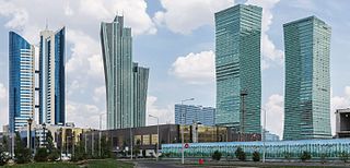
Nur-Sultan, previously known as Astana, is the capital city of Kazakhstan. The city acquired its present name on 23 March 2019, following a unanimous vote in Kazakhstan's parliament. It was named after Nursultan Nazarbayev, President of Kazakhstan from 1990 to 2019.
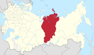
Omsk Oblast is a federal subject of Russia, located in southwestern Siberia. The oblast has an area of 139,700 square kilometers (53,900 sq mi). Its population is 1,977,665 with the majority, 1.12 million, living in Omsk, the administrative center.

Russian Turkestan was the western part of Turkestan within the Russian Empire’s Central Asian territories, and was administered as a Krai or Governor-Generalship. It comprised the oasis region to the south of the Kazakh Steppe, but not the protectorates of the Emirate of Bukhara and the Khanate of Khiva.

Zhetysu, or Jeti-Suu, is a historical name of a part of Central Asia corresponding to the southeastern part of modern Kazakhstan. It owes its name, meaning "seven rivers" in Kazakh, to the rivers that flow from the southeast into Lake Balkhash. Zhetysu falls into today's Almaty Region and other South-Eastern parts of Kazakhstan and some parts of Northern Kyrgyzstan.

The Transcaspian Oblast, or just simply Transcaspia, was the section of Russian Empire and early Soviet Russia to the east of the Caspian Sea during the second half of the 19th century until 1924.
Omsk Time (OMST) is a time zone in Russia that is six hours ahead of UTC (UTC+06:00), and 3 hours ahead of Moscow Time (MSK).It is used in Omsk Oblast.

There has been a substantial population of Russian Kazakhstanis since the 19th century. Although their numbers have been reduced since the breakup of the Soviet Union, they remain prominent in Kazakh society today. Russians formed a plurality of the Kazakh SSR's population for several decades.

Saken Seifullin was a pioneer of modern Kazakh literature, poet and writer, and national activist. He was the founder and first head of the Union of Writers of Kazakhstan, he was the author of controversial literature calling for greater independence of Kazakhs from Soviet and Russian power. He met repression and was executed in 1938. The Soviet government posthumously rehabilitated him during de-Stalinization.
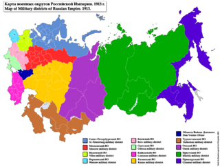
In the Imperial Russian Army, a military district was a territorial association of military units, formations, military schools, and various local military establishments. This territorial division type was utilized to provide a more efficient management of army units, their training and other operations activities related to combat readiness.
Yeniseysk Governorate was a governorate (guberniya) of the Russian Empire and later of the Russian Socialist Federative Soviet Republic.

Syr-Darya Oblast was one of the oblasts of the Russian Empire was part of Russian Turkestan. Its center was Tashkent.

Oblasts of the Russian Empire were considered to be administrative units and were included as parts of Governorates General or krais. The majority of then-existing oblasts were located on the periphery of the country or covered the areas where Cossacks lived.
Ufa Governorate was a governorate of the Russian Empire with its capital in the city Ufa. It was created in 1865 by separation from Orenburg Governorate. On June 14, 1922 the governorate was transformed into the Bashkir Autonomous Soviet Socialist Republic. It occupied an area of 122,005 km2 and the territory of the governorate was divided to 6 uyezds.

The Semirechyenskaya Oblast was an oblast (province) of the Russian Empire. It corresponded approximately to most of present-day southeastern Kazakhstan and northeastern Kyrgyzstan. It was created out of the territories of the northern part of the Khanate of Kokand that had been part of the Kazakh Khanate. The name "Semirechye" itself is the direct Russian translation of the historical region of Jetysu. Its site of government was Verniy.

Oryol Governorate or the Government of Oryol, was an administrative division of the Russian Empire and the early Russian SFSR, which existed from 1796 to 1928. Its seat was in the city of Oryol.
The Central Asian revolt of 1916, also known as the Semirechye Revolt and as Urkun in Kazakhstan and Kyrgyzstan, was an anti-Russian uprising by the indigenous inhabitants of Russian Turkestan sparked by the conscription of Muslims into the Russian military for service on the Eastern Front during World War I. The rampant corruption of the Russian colonial regime and Tsarist colonialism in all its economic, political, religious, and national dimensions are all seen as the contributing causes.
Grey Ukraine is an unofficial name for a region in Southern Siberia and Northern Kazakhstan, where mass settlement of Ukrainians took place from the middle of the 18th to the beginning of the 20th century. Around 1917-1920 there was a movement for Ukrainian autonomy in the region.

The Steppes electoral district was a constituency created for the 1917 Russian Constituent Assembly election. The electoral district covered the Akmolinsk Oblast and the Semipalatinsk Oblast. According to Wade (2004), it is unclear whether the election was carried through to completion in the electoral district.
The Military Governor was the highest government and military official in a Governorate or Oblast, who was also the commander of troops in his area in the Russian Empire until 1917.

Kokshetau Oblast, was an administrative division of the former Kazakh Soviet Socialist Republic (1944–1991) in the Soviet Union, established on March 16, 1944. Upon Kazakhstan's independence in 1991, the oblast continued to exist until May 3, 1997. It was formerly known between 1944 and 1993 as Kokchetav Oblast.

