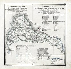
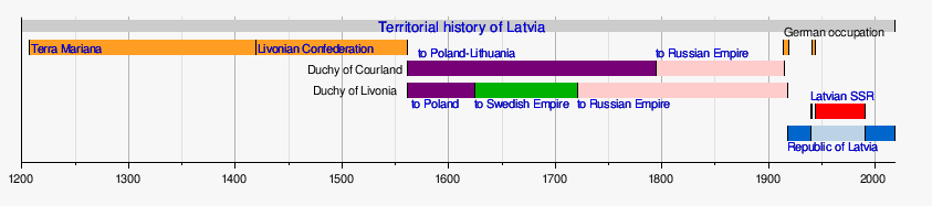
Courland Governorate,[a] also known as the Province of Courland or Governorate of Kurland,[1][2] and known from 1795 to 1796 as the Viceroyalty of Courland,[b] was an administrative-territorial unit (guberniya) and one of the Baltic governorates of the Russian Empire. Its area roughly corresponded to Kurzeme, Zemgale and Sēlija of modern-day Latvia.
In 1915, during the World War I, Courland was occupied by the German Empire and included into the Ober Ost military administration. While the local Baltic German nobility was cooperating with the German administration, several Latvian leaders from Courland retreated to the neighboring governorates of Livonia and Estonia, still held by Russian forces. After the Russian Revolution in March 1917, those Latvian leaders formed the Provisional Land Council of Courland that met at 27 April 1917 in the Estonian city of Tartu, and was recognized by the Russian Provisional Government as the representative body of the occupied Courland Governorate. At the same time, the Provisional Government in Petrograd appointed Latvian politician Jānis Čakste as the commissar of Courland, a newly created post that replaced the old office of governor. Since Courland was under German control, Čakste and the Provisional Land Council focused their activities on assisting war refugees who fled from Courland, mainly to Livonia and Estonia.[3]
In September–October 1917, German forces advanced from Couland and took the city of Riga and the main Baltic islands, and in November 1917, the Bolshevik Revolution broke out in Russia. Already on 16 November 1917, the Latvian Provisional National Council was created in Valka (Livonia) on 30 November, and it proclaimed Latvia as an autonomous province within the ethnographic boundaries of the Latvian people that included Courland. On 15 January 1918, the same body proclaimed Latvia as independent republic.[4]
Already in February 1918, German forces proceeded further and occupied the entirety of Livonia and Estonia, but Soviet Russia continued to claim sovereignty over all occupied regions, including Courland, until the signing of the Treaty of Brest-Litovsk on 3 March 1918, when it accepted the loss of the Courland Governorate. On 8 March 1918, representatives of the Courlandian Baltic Germans met in Jelgava (Mitau) and proclaimed the creation of an independent state, named the Duchy of Courland and Semigallia in reference to the historical duchy of the same name. They offered the Courlandian ducal throne to the German emperor, thus trying to establish Courland as a client state of the German Empire. Already on March 15, Germany recognized the newly proclaimed state, that in reality existed only formally since all effective power over the region was still held by German military administration of Ober Ost. On 5 November 1918, Courland was united with neighboring Livonia–Estonia to form the United Baltic Duchy, but that political project failed, since on 18 November 1918, the Republic of Latvia was proclaimed, thus uniting all Latvian lands, including Courland.[5][6][7]
It was situated between 55°41' and 57°451⁄2' N. Of its total border of 1,260 versts (1,344km), the sea border is 320 versts (341km). The border with Prussia is only 6 versts (6.4km) long and lacks natural boundaries.
The surface area of the province is 26,112 square versts (29,716km2).
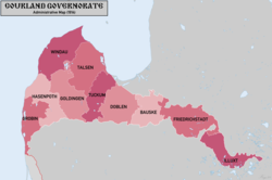
Subdivisions
After the annexation to the Russian Empire, the Kurzeme Governorate united the lands of the Duchy of Courland and Semigallia and the Piltene district, both of which retained their previous administrative divisions.
After the administrative reform of 1819, the area of Pilten was incorporated into the territory of the province as the district of Windau (Hauptmannschaft Windau) and the district of Hasenpoth (Hauptmannschaft Hasenpoth). After the reform of 1819, the castle lord of Kandava moved to Talsi. The area of Palanga up to the Prussian border was also added to the Kurzeme province from the Vilna Governorate. The province was divided into ten districts, or Hauptmannschaft, whose administrative authorities were located in the towns of the same name, with the exception of Talsi and Ilūkste, which had only the rights of towns. Each district had its own court with a local police force. Until 1864, every two districts were merged into Oberhauptmannschaft, which contained the Oberhauptmann and the Evangelical Lutheran Church dean's districts under the authority of the Oberhofgericht (Court of the Governor's Court).
The highest court is the Courts of Kurland (Kurländisches Oberhofgericht), the courts of appeal are the Higher Hauptmanns Courts (Oberhauptmannsgericht), The courts of first instance are the Hauptmannsgericht, the county courts (kreisgericht) for the peasantry, and the lowest level of the court system for the peasantry are the parish courts (Gemeindegericht).[9]
Administration
Unofficial flag of Courland Governorate
The province of Courland was governed by a governor appointed by the emperor. The representative body of local government was the Landtag (Kurländischer Landtag), which consisted of parish commissioners (Kirchspielsbevollmächtigter, Konvokant) elected by the parishes (Landtagskirchspiel, Parochie) by parish assemblies (Kirchspielsversammlung), In the parish meetings (Kirchspielsversammlung) all large landowners of the parish could participate, the executive body - a noble committee headed by a land commissioner (Landesbevollmächtige) was elected to conduct its sessions.
The residence of the governors was in Jelgava Castle, where the governorate's administrative offices were also located. During the existence of the Baltic Governorate (1801-1876, 1906–1909), the governors of Kurzeme were subordinate to the governor-general of the Baltic Provinces (German: Generalgouverneur der Ostseeprovinzen)., who resided in the Riga Castle.[10]
Until Russification, almost all governors of Courland were German-Baltic noblemen. Until then, the language of administration in the highest authorities and courts of the province was German, but in the parish courts, according to the Courland peasant laws, the records were also kept in Latvian.[11]
1915–1917 Tatishchev, Pyotr Vasilyevich Gendrikov, Strakhov (in exile in Tartu after the German invasion of Courland in July 1915).
Economy
In the 19th century the province was predominantly agrarian. In 1817, serfdom was abolished in the province and peasants were granted personal freedom, but all land remained the property of landlords. In 1863 the peasants received the right to buy land as personal property, and a class of land owning peasants began to form. The land owning peasants, along with the German landlords, were the main suppliers of commercial agricultural products. The main crops grown in the province were rye, wheat, barley, peas, oats, and potatoes. Horticulture and gardening are well developed.
Industry of the province is mostly manufacturing. In 1912 there were about 200 factories and plants (mills, vodka mills, sawmills, tanneries, brick mills, flax-spinning factories, etc.) and about 500 cottage industries.
Railway construction was developing on the territory of the province. The Riga - Mitava railroad was built in 1867 and in 1871-76 a section of the Libava - Romena railroad. All in all the length of the railway lines in the province was over 560 versts.
Education in the province was better than the Russian average. In the 1910s there were 8 secondary schools (over 3 thousand students), 13 special secondary schools (over 460 students), 790 lower secondary schools (36.9 thousand students) in the province. In the province in 1913 there were 33 hospitals with 1,300 beds.[12]
Language
By the Imperial census of 1897.[13] In bold are languages spoken by more people than the state language.
↑Симонян, Р.З. (2018). История медицины: с древнейших времен до современности. Издательский дом Академии Естествознания. doi:10.17513/np.296 (inactive 11 July 2025). ISBN978-5-91327-518-9.{{cite book}}: CS1 maint: DOI inactive as of July 2025 (link)
¹ Italics indicates renamed or abolished governorates, oblasts, etc on 1 January 1914. ² An asterisk (+) indicates governorates formed or created with renaming after 1 January 1914. ³ Ostsee or Baltic general-governorship was abolished in 1876.
This page is based on this Wikipedia article Text is available under the CC BY-SA 4.0 license; additional terms may apply. Images, videos and audio are available under their respective licenses.