Related Research Articles
The Campos Basin is one of 12 coastal sedimentary basins of Brazil. It spans both onshore and offshore parts of the South Atlantic with the onshore part located near Rio de Janeiro. The basin originated in Neocomian stage of the Cretaceous period 145–130 million years ago during the breakup of Gondwana. It has a total area of about 115,000 square kilometres (44,000 sq mi), with the onshore portion small at only 500 square kilometres (190 sq mi).
Petróleo Brasileiro S.A., better known by the acronym Petrobras, is a state-owned Brazilian multinational corporation in the petroleum industry headquartered in Rio de Janeiro, Brazil. The company's name translates to Brazilian Petroleum Corporation — Petrobras.
The Boscán Oil Field is located 40 km southwest of Maracaibo, Venezuela, and covers an area of about 660 square kilometers. The field produces a 10.5 degree API gravity crude oil from the Eocene Misoa Formation locally called the Boscán Formation. Current estimates of oil in place are greater than 25 billion barrels of oil.

The San Juan Basin is a geologic structural basin located near the Four Corners region of the Southwestern United States. The basin covers 7,500 square miles and resides in northwestern New Mexico, southwestern Colorado, and parts of Utah and Arizona. Specifically, the basin occupies space in the San Juan, Rio Arriba, Sandoval, and McKinley counties in New Mexico, and La Plata and Archuleta counties in Colorado. The basin extends roughly 100 miles (160 km) N-S and 90 miles (140 km) E-W.
Brazil is the largest energy consumer in South America. It is the most important oil and gas producer in the region and the world's largest ethanol fuel producer. The government agencies responsible for energy policy are the Ministry of Mines and Energy (MME), the National Council for Energy Policy (CNPE), the National Agency of Petroleum, Natural Gas and Biofuels (ANP) and the National Agency of Electricity (ANEEL). State-owned companies Petrobras and Eletrobras are the major players in Brazil's energy sector, as well as Latin America's.
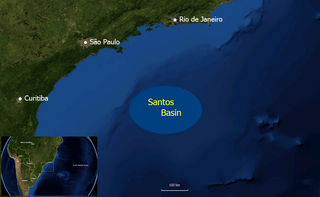
The Santos Basin is an approximately 352,000 square kilometres (136,000 sq mi) large mostly offshore sedimentary basin. It is located in the south Atlantic Ocean, some 300 kilometres (190 mi) southeast of Santos, Brazil. The basin is one of the Brazilian basins to have resulted from the break-up of Gondwana since the Early Cretaceous, where a sequence of rift basins formed on both sides of the South Atlantic; the Pelotas, Santos, Campos and Espírito Santo Basins in Brazil, and the Namibia, Kwanza and Congo Basins in southwestern Africa.
The Lapa oil field is a deepwater oil field in the pre-salt Guaratiba Group of the South Atlantic Santos Basin, 270 kilometres (170 mi) off the coast of São Paulo, Brazil. The field lies in water depths of approximately 2,140 metres (7,020 ft). When the discovery of the field was initially reported, it caused widespread commotion because of the speculated size of the field, which surpassed the Mexican Cantarell Complex, the biggest oil field complex outside of the Middle East. The size of Lapa, then known as Carioca and later as Sugar Loaf, was announced as possibly "as large as 33 billion barrels [5.2 billion cubic metres]". Later appraisal of the field drastically reduced the reserves to the current estimate of 459 million barrels.

The Paraná Basin is a large cratonic sedimentary basin situated in the central-eastern part of South America. About 75% of its areal distribution occurs in Brazil, from Mato Grosso to Rio Grande do Sul states. The remainder area is distributed in eastern Paraguay, northeastern Argentina and northern Uruguay. The shape of the depression is roughly elliptical and covers an area of about 1,500,000 km2 (580,000 sq mi).
Marlim is a giant Brazilian oil field located in the north-eastern part of the Campos Basin, about 110 km offshore Rio de Janeiro, in water depths ranging from 650 to 1,050 m. Marlim means marlin, in Portuguese.
Iara oil field is a large ultra-deepwater pre-salt oil field located in the Santos Basin, 230 km (140 mi) off the coast of Rio de Janeiro, Brazil, north of Tupi oil field. It covers an area of nearly 300 km2 (120 sq mi).

Libra oil field is a large ultra-deepwater oil prospect located in the Santos Basin, about 230 kilometres (140 mi) off the coast of Rio de Janeiro, Brazil, north of Tupi field. Libra is in the process of being tested and may turn out to be the largest pre-salt find in the basin, ahead of the Tupi oil field, making the largest find since Cantarell Field in 1976. National Agency of Petroleum (ANP) officials are confident Libra will contain even more recoverable oil than Franco oil field.

The Vaca Muerta Formation, commonly known as Vaca Muerta, is a geologic formation of Late Jurassic to Early Cretaceous age, located in the Neuquén Basin in northern Patagonia, Argentina. It is well known as the host rock for major deposits of shale oil and shale gas.
The Sapinhoá oil field is an oil field located in the southern Brazilian Santos Basin, 310 kilometres (190 mi) off the coast of Rio de Janeiro in a water depth of 7,065 feet (2,153 m). It was discovered in 2008 and originally named Guará field, under development by Petrobras. The oil field is operated by Petrobras and owned by Petrobras (45%) Repsol Sinopec Brazil (25%) and BG Group (30%). The total proven reserves of the Sapinhoá oil field range from 1,100–2,000 million barrels.

The Araripe Basin is a rift basin covering about 8,000 square kilometres (3,100 sq mi), in Ceará, Piauí and Pernambuco states of northeastern Brazil. It is bounded by the Patos and Pernambuco lineaments, and is situated east of the Parnaíba Basin, southwest of the Rio do Peixe Basin and northwest of the Tucano and Jatobá Basins.
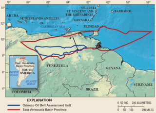
Carabobo is an oil field located in Venezuela's Orinoco Belt. As one of the world's largest accumulations of recoverable oil, the recent discoveries in the Orinoco Belt have led to Venezuela holding the world's largest recoverable reserves in the world, surpassing Saudi Arabia in July 2010. The Carabobo oil field is majority owned by Venezuela's national oil company, Petroleos de Venezuela SA (PDVSA). Owning the majority of the Orinoco Belt, and its estimated 1.18 trillion barrels of oil in place, PDVSA is now the fourth largest oil company in the world. The field is well known for its extra Heavy crude oils, having an average specific gravity between 4 and 16 °API. The Orinoco Belt holds 90% of the world's extra heavy crude oils, estimated at 256 billion recoverable barrels. While production is in its early development, the Carabobo field is expected to produce 400,000 barrels of oil per day.
The Florianópolis Formation is a geological formation of the Santos Basin offshore of the Brazilian states of Rio de Janeiro, São Paulo, Paraná and Santa Catarina. The predominantly sandstone formation with interbedded shales and siltstones dates to the Early Cretaceous period; Albian epoch and has a thickness in the type oil well of 343 metres (1,125 ft).
The Itanhaém Formation is a geological formation of the Santos Basin offshore of the Brazilian states of Rio de Janeiro, São Paulo, Paraná and Santa Catarina. The predominantly shale formation with marls, siltstones and sandstones dates to the Early Cretaceous period; Early Albian epoch and has a maximum thickness of 1,500 metres (4,900 ft). The formation is the reservoir rock of the Tambaú Field in the Santos Basin.
The Guaratiba Group is a geological group of the Santos Basin offshore of the Brazilian states of Rio de Janeiro, São Paulo, Paraná and Santa Catarina. The group forms the pre-salt layer in the petroleum-rich basin and hosts the biggest oil fields of Brazil, as Tupi, Júpiter and many more. The group contains, depending on the definition, three to four formations and dates to the Early Cretaceous period; Hauterivian to Early Aptian epochs. The total thickness of the group, representing the first phase of sedimentation after the break-up of Gondwana in the Santos Basin, is estimated at 4,200 metres (13,800 ft).

The Pelotas Basin is a mostly offshore sedimentary basin of approximately 346,000 square kilometres (134,000 sq mi) in the South Atlantic, administratively part of the southern states Santa Catarina and Rio Grande do Sul of Brazil and the departments Cerro Largo, Rocha and Treinta y Tres of Uruguay.

The geology of Bulgaria consists of two major structural features. The Rhodope Massif in southern Bulgaria is made up of Archean, Proterozoic and Cambrian rocks and is a sub-province of the Thracian-Anatolian polymetallic province. It has dropped down, faulted basins filled with Cenozoic sediments and volcanic rocks. The Moesian Platform to the north extends into Romania and has Paleozoic rocks covered by rocks from the Mesozoic, typically buried by thick Danube River valley Quaternary sediments. In places, the Moesian Platform has small oil and gas fields. Bulgaria is a country in southeastern Europe. It is bordered by Romania to the north, Serbia and North Macedonia to the west, Greece and Turkey to the south, and the Black Sea to the east.
References
- ↑ Petrobras (2010). "Descoberta de indícios de petróleo no pré-sal em Albacora Leste". Archived from the original on 2012-12-31. Retrieved January 28, 2014.
- ↑ "Repsol YPF 3rd Largest Oil Producer in Brazil 2006". lngplants.com. 2006. Retrieved 2013-06-09.
- ↑ "Petro Rio to acquire Petrobras' stake in Albacora Leste field for $2.2bn" . Retrieved 2022-04-29.
- 1 2 3 4 5 Candido, A., and Cora, C.A.G., 1992, The Marlim and Albacora Giant Fields, Campos Basin, Offshore Brazil, AAPG Memoir 54, Halbouty, M.T., editor, Tulsa: American Association of Petroleum Geologists, ISBN 0891813330