
Alberton is a city situated on the southern part of the East Rand, of the Gauteng Province in South Africa. It was incorporated into the Ekurhuleni metropolitan municipality in the year 2000 and celebrated its centenary year in 2005. According to the 2011 census conducted by Statistics South Africa, it has a population of 121,536; but this figure excludes the black township of Thokoza, which has a population of 105,827. Alberton is described as a typical bedroom community, one which is primarily residential in character, with most of its workers commuting to work in nearby suburbs or cities. The city has multiple access roads to all major freeways in Gauteng and is situated on the banks of the Natal Spruit close to the major urban centres of Johannesburg, which lies 15 km (9 mi) to the northwest - and Pretoria - which is 76 km (47 mi) to the north. Alberton has an elevation of approximately 1,570 m (5,150 ft) above sea level.

Alberton is a metropolitan suburb in Adelaide, South Australia, about 20 minutes drive from the city. Part of the City of Port Adelaide Enfield, it is bordered by the suburbs of Rosewater, Queenstown, Cheltenham and Port Adelaide.

Port Albert is a coastal town in Victoria, Australia, on the coast of Corner Inlet on the Yarram - Port Albert Road, 82 kilometres (51 mi) south-east of Morwell, 236 kilometres (147 mi) south-east of Melbourne, in the Shire of Wellington. At the 2016 census, Port Albert had a population of 293.
Foster is a dairying and grazing town 174 kilometres (108 mi) south-east of Melbourne on the South Gippsland Highway in Victoria, Australia. At the 2016 census Foster had an urban population of 1,164. It is about 20 kilometres (12 mi) north of the Gippsland coastline which includes Shallow Inlet, Corner Inlet, Waratah Bay, Yanakie and Wilsons Promontory.
Bass is a small rural town 113 kilometres (70 mi) south-east of Melbourne via the South Gippsland and Bass Highways, in the Bass Coast Shire of Gippsland, Victoria, Australia. At the 2006 census, Bass and the surrounding area had a population of 937.

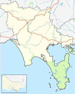
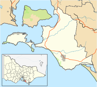
Alberton is a small town in Victoria, Australia. It is located along the South Gippsland Highway, 7 kilometres south of Yarram and 216 kilometres east of Melbourne. Albert River passes through the town. At the 2006 census, Alberton had a population of 162.

Alberton is a Canadian town located in Prince County, Prince Edward Island. It is situated in the western part of the county in the township of Lot 5. The population was 1,145 as of the 2016 census.

Alberton Oval is located in Alberton, a north-western suburb of Adelaide, South Australia. The ground is a public park and exclusively leased to the Port Adelaide Football Club for Australian rules football.
Grand Junction Road is the longest east–west thoroughfare in the Adelaide metropolitan area, and is located approximately 8 kilometres north of the Adelaide city centre. Travelling from the Port Adelaide region, it is mostly a double-lane sealed road running 21 kilometres to the base of the Adelaide Hills. The western end at the intersection of Old Port Road, 300 metres east of a causeway which separates the Port River from West Lakes. The 2.4 kilometre section of road that continues west of Old Port Road to Semaphore South is named Bower Road. The eastern end of Grand Junction Road is in the suburb of Hope Valley, at the intersection of Hancock Road and Lower North East Road, just before the latter proceeds into the Adelaide Hills, past Anstey Hill Recreation Park and on towards the towns of Houghton and Inglewood.
Stony Creek is a small township in South Gippsland, Victoria, Australia, located roughly between Meeniyan and Foster. At the 2016 census, it had a population of 281.
Meeniyan is a small country town on the South Gippsland Highway between Leongatha and Foster in Australia.

The Alberton Football Netball League is an Australian rules football league covering the South Gippsland region of Victoria, Australia.

Queenstown is a north-western suburb of Adelaide about 10.5 km from the CBD, in the state of South Australia, Australia and the city council area of Port Adelaide Enfield.

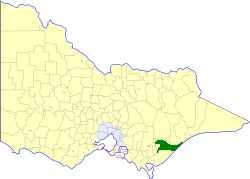
The Shire of Alberton was a local government area about 220 kilometres (137 mi) southeast of Melbourne, the state capital of Victoria, Australia. The shire covered an area of 1,868.83 square kilometres (721.6 sq mi), and existed from 1855 until 1994.
The Shire of Rosedale was a local government area stretching between the towns of Traralgon and Sale in the Gippsland region of Victoria, Australia. The shire covered an area of 2,276.6 square kilometres (879.0 sq mi), and existed from 1869 until 1994.

The Shire of Maffra was a local government area about 20 kilometres (12 mi) north-northwest of Sale, the major regional centre in central Gippsland, Victoria, Australia. The shire covered an area of 4,167.43 square kilometres (1,609.1 sq mi), and existed from 1875 until 1994.
Kongwak is a small town in Victoria, Australia. It is located on the Korumburra to Wonthaggi Road southeast of Melbourne, in the South Gippsland Shire At the 2006 census, Kongwak had a population of 193.

Alberton is a locality in the City of Gold Coast in Queensland, Australia. It is bounded in the north by the Logan River and in the west by its tributary, the Albert River.
Alberton is an unincorporated community in Howard County, Maryland, United States. A postal office operated in the community from 3 February 1854 to 1 March 1943.
The District Council of Queenstown and Alberton was a local government area of South Australia established in 1864 and abolished in 1898.
