
Stratford-upon-Avon, commonly known as just Stratford, is a market town and civil parish in the Stratford-on-Avon district, in the county of Warwickshire, in the West Midlands region of England. It is situated on the River Avon, 91 miles (146 km) north-west of London, 22 miles (35 km) south-east of Birmingham and 8 miles (13 km) south-west of Warwick. The estimated population in 2007 was 25,505, increasing to 27,445 at the 2011 census. As of 2018, the population that resides in the Stratford-on-Avon district has a population figure of 130,098.

Jackson County is a county located in the far southwest of the U.S. state of North Carolina. As of the 2010 census, the population was 40,271. Since 1913 its county seat has been Sylva, which replaced Webster.

Edwards is an unincorporated town, a post office, and a census-designated place (CDP) located in and governed by Eagle County, Colorado, United States. Edwards is the principal town of the Edwards, CO Micropolitan Statistical Area. The Edwards post office has the ZIP Code 81632. At the United States Census 2010, the population of the Edwards CDP was 10,266, while the population of the 81632 ZIP Code Tabulation Area was 10,267. The Edwards Metropolitan District provides services.

Georgetown is a city in Quitman County, Georgia, United States. It is on the Alabama-Georgia state line next to Walter F. George Lake and across the Chattahoochee River from Eufaula, Alabama. The population was 2,513 at the 2010 census. In 2006, Georgetown and Quitman County voted to consolidate their governments, becoming the smallest such consolidated entity in the Lower 48 states.

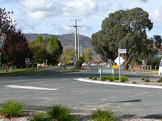
Stratford is a town on the Avon River in Victoria, Australia, 232 kilometres (144 mi) east of Melbourne on the Princes Highway in Shire of Wellington. At the 2006 census, Stratford had a population of 1950. The town services the local regional community and travellers on the Princes Highway. Stratford's principal industries are dairying, sheep, cattle and horse breeding and vegetable crops. The town has numerous coffee shops and cafes, a cellar door for a local winery, Design Gallery, model railway shop, a pub, parks and playgrounds for car travellers to break their journey.
Cape Breton North and Victoria was a federal electoral district in the province of Nova Scotia, Canada, that was represented in the House of Commons of Canada from 1904 to 1968.

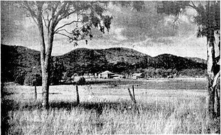
Boisdale is a town in the Central Gippsland region of Victoria, Australia, located on Briagolong Road, north of Maffra, in the Shire of Wellington. At the 2016 census, Boisdale and the surrounding area had a population of 275. It is a small town in the heart of Gippsland's dairying distinct. Boisdale includes not only the town itself, but the area surrounding the town, comprising mostly dairy and vegetable farms. It is situated approximately 9 km north of the larger town of Maffra. Boisdale is 176 km east of Australia's second largest city, Melbourne, the capital of Victoria.

Briagolong is a town in the Australian state of Victoria, located 20 kilometres north of Maffra and some 270 kilometres east of Melbourne, in the Shire of Wellington region of Gippsland. At the 2016 census, Briagolong had a population of 1,081.

Southmont is an unincorporated community and census-designated place (CDP) in Davidson County, North Carolina, United States. As of the 2010 census it had a population of 1,470. It is located along North Carolina State Highway 8 on the northern shores of High Rock Lake. There is an organized effort underway to incorporate the community as "The Village of Southmont".
Walwa, is a town in the Shire of Towong in north east Victoria, Australia. The town is located 1 kilometre from the Murray River on the former Murray Valley highway between Wodonga and Corryong. At the 2016 census, the Walwa population had declined to just 177 having been 268 just ten years earlier.

The Shire of Maffra was a local government area about 20 kilometres (12 mi) north-northwest of Sale, the major regional centre in central Gippsland, Victoria, Australia. The shire covered an area of 4,167.43 square kilometres (1,609.1 sq mi), and existed from 1875 until 1994.

Boisdale is a community in the Canadian province of Nova Scotia, located in the Cape Breton Regional Municipality on Cape Breton Island. It was named for Lochboisdale, the main village of the island of South Uist in the Outer Hebrides of Scotland. Neil Campbell was granted land in the area in 1836. In 1821, Thomas Lockman, an Irishman who came to Cape Breton in 1799 and lived at Lloyds Cove, petitioned for land, and got a grant next to Neil Campbell's lot in 1842. Angus McIntyre got a grant in 1846, and in 1869, land at what was then called Boisdale was granted to Dugald O'Henley. Farming and lumbering were the basic industries. In 1840, a small log church was constructed by Father John Grant on where the present-day church resides. It was replaced by a new building in 1862, which burned down in September 1928. In 1846, Boisdale Parish was officially erected. A post office was established at Boisdale Chapel in 1854. On October 1, 1873 a new post office was established with Michael McIntyre as office keeper. In 1874, the total population of Boisdale, was that of 500. During this time, the area had 1 store, 3 sawmills, 1 grist mill, and a post office, of which mail was delivered bi-weekly. By 1908, it contained 1 hotel, 2 general stores, 1 saw mill, and 2 gristmills. The population at that time, was 300. In 1915, a newer 40,000 gallon open-wood tank was built replacing an older 40,000 gallon wood tank, for the water services within the area. Father Alexander F. MacGillivray, whom was the fifth pastor of Boisdale, had installed the bell within St. Andrew's Church in Boisdale, in 1882, and had built the Glebe house there in 1890. A new and larger bell, cast by the Meneely Bell Company of New York, was installed in St. Andrew's Church, by Father MacGillivray, on Nov. 14, 1897. In 1921, Father Gillis built St. Andrew's Parish Hall, James Johnston of Red Islands, Nova Scotia was the contractor. The formal opening of the hall was held on September 13, 1921. The original St. Andrew's Parish Church was destroyed by fire on Sunday, September 11, 1927. Construction of a new stone church commenced in June 1929, with help from workers from Quebec. The design style of the church was inspired by the Norman architecture as well as the St Mary the Virgin, Iffley church in England. Link, Weber, and Bowers, architects hailing from Pittsburgh, Pennsylvania, designed the architecture of the church. The approximate cost of the church was $55,000, but the exterior walls had to be repointed during the summer of 1930, which added an extra $7,500 to the total cost. The new church was blessed on Sunday, August 31, 1930, by Bishop James Morrison, assisted by the late Bishop Alexander MacDonald. In 1931, the total population of Boisdale was 449. There was also a train station located on Station Road, in Boisdale during this time. The former Glebe House for St. Andrew's Church was burnt down in 2011, due to a fire. Dugald Smith was the teacher in 1839, and a school-house had been constructed by that time. A new school-house was completed in 1917. Education within the area dates back to the early 1800s, with the Boisdale Consolidated School closing in 2003. The enrolment for the school, in the 1957–1958 academic year, were 82 students, and 3 teachers. By the 1987 Academic year, there were only 21 students, all within grades primary-second, and fourth. In 1943, within what is now known as Ironville, then known as Boisdale Barrachois until 1907, a youth summer camp was built. The two-week summer camp operated from 1943, until its closure in the 1980s. Efforts were made in 1997 to re-open the camp in the spring of 1998. The camp officially closed in 2010, due to the deterioration of some of the buildings. The property in which the youth camp was on, was sold in 2013. In August 1977, the community of Boisdale, as well as Father Webb, unveiled and held a ceremony for the opening of an indoor stone, ice-skating rink. Father Webb also built a Co-op store, in the 70s. A new hall above the store replaced the old Holyrood Hall, which burned down on December 18, 1975. By 1956, the population of Boisdale was 133. Over the years the population decreased, down to 138 by 1991, and estimated to be 105 by the 2001 Census.To the Hill of Boisdale,a book on the genealogical history of Boisdale was published in 1986, and later in a revised edition in 2001, by Father Allan MacMillan, then Priest of the Diocese of Antigonish. Highland Gold Maple, a family-owned and operated sugar maple producer, has been operating within the area for over fifteen years. In late April 2018, their operation burned to the ground due to a fire. By March 2019, Highland Gold Maple had rebuilt the Sugar Shack and are back in operation.

Culp Creek is an unincorporated community in Lane County, Oregon, United States, southeast of Cottage Grove on the Row River. It lies on Row River Road between Dorena and Disston.

Gayville is a hamlet lying five miles (8 km) north of the hamlet of Constantia in the town of Constantia in Oswego County, New York, United States.

Venado is an unincorporated community in Sonoma County, California, United States, and is located about 12 miles west of Healdsburg, along Mill Creek Road, below the north slope of Knoll Ridge, on the south bank of Gray Creek, at an elevation of 1,102 feet. The community had a post office from 1921 to 1941. Venado was devastated by the Walbridge Fire in 2020, part of the larger LNU Lightning Complex fire. The Walbridge Fire destroyed many homes and structures in the area, including the Venado Post Office and Daniels School.
Bouldercombe is a rural town and locality in the Rockhampton Region, Queensland, Australia. In the 2016 census, Bouldercombe had a population of 1,085 people.

West Toodyay was the original location of the town of Toodyay, Western Australia. It is situated in the Toodyay valley, 85 kilometres (53 mi) north east of Perth. The Toodyay valley, discovered by Ensign Robert Dale in 1831, was opened up for settlement in 1836. The original site for the town of Toodyay was determined in 1836 and its boundaries were finalized 1838. The first survey of the town was carried out in 1849. After several serious floods, the decision was made to move the town of Toodyay to higher ground. In 1860, the new town of Newcastle was established 3 miles (4.8 km) further upstream. Newcastle was renamed in 1910 to Toodyay, and the original site became known as West Toodyay.

Morinish is a rural locality in the Rockhampton Region, Queensland, Australia. In the 2016 census Morinish had a population of 89 people.

Whiteflat is a ghost town in Motley County, Texas, United States. The population was estimated to be 3 at the 2000 census.
South Lima is a hamlet and census-designated place (CDP) in Livingston County, New York, United States. Its population was 240 as of the 2010 census. South Lima had a post office from January 10, 1854, until April 17, 2010; it still has its own ZIP code, 14558.
