Avon River (Gippsland, Victoria)

Last updated

Avon
VM 0256 Stratford - Avon River.jpg
On the Avon River near Stratford.
Australia Victoria relief location map.jpg
Red pog.svg
Location of the Avon River mouth in Victoria
EtymologyOriginally called the Avoca; named the Avon by Angus McMillan [1] [2] [3]
Native name
Location
Country Australia
State Victoria
Region South East Corner (IBRA), South East Coastal Plain (IBRA), West Gippsland
Local government area Wellington
Physical characteristics
Source Mount Wellington, Great Dividing Range
  locationMiler Spur, Avon Wilderness Park
  coordinates 37°30′38″S146°51′44″E / 37.51056°S 146.86222°E / -37.51056; 146.86222
  elevation664 m (2,178 ft)
Mouth Lake Wellington
  location
east of Sale; southeast of Stratford
  coordinates
38°2′57″S147°16′7″E / 38.04917°S 147.26861°E / -38.04917; 147.26861 Coordinates: 38°2′57″S147°16′7″E / 38.04917°S 147.26861°E / -38.04917; 147.26861
  elevation
0 m (0 ft)
Length122 km (76 mi)
Basin features
River system West Gippsland catchment
Tributaries 
  left Turton River, Valencia Creek, Freestone Creek, Blackall Creek, Perry River
  rightMount Hump Creek, McColl Creek, Ben Cruachan Creek, Navigation Creek, Nuntin Creek
National park Avon Wilderness Park
[7] [8]

The Avon River is a perennial river of the West Gippsland catchment, located in the West Gippsland region, of the Australian state of Victoria. The Avon, forms an important part of the Latrobe sub-catchment, draining the south eastern slopes of the Great Dividing Range, to form the Gippsland Lakes.

Contents

Location and features

The Avon River rises on the south eastern slopes of Mount Wellington, below Miller Spur, part of the Great Dividing Range within the Avon Wilderness Park. [9] The rivers flows in a highly meandering course generally south, then east, then south by southeast, joined by ten tributaries including the Turton River and the Perry River, before reaching its mouth to form Lake Wellington east of Sale and southeast of Stratford. Within Lake Wellington, the Avon forms its confluence with the Latrobe River, empties into Bass Strait via the Mitchell River south of Lakes Entrance. The river descends 664 metres (2,178 ft) over its 122-kilometre (76 mi) course. [8]

The upper reaches are contained in the rugged, heavily forested and largely inaccessible, Avon Wilderness Park. The river passes through forested hillsides, then cleared agricultural land. Around Stratford the river has dug a wide channel up to 500 metres (1,600 ft) across, composed mainly of sand banks and pebble banks. The river then forms a boundary for the Macallister Irrigation District, with Nuntin Creek joining 10 kilometres (6.2 mi) downstream of Stratford contributing a large amount of irrigation drainage to the river.

Considerable demand is placed on the Latrobe and Thomson Rivers for supply of Melbourne's water, industrial use in Australia's largest pulp and paper mill and the power industry in the Latrobe Valley, and for irrigation. The Avon escapes any major impoundment or diversion.

The river was important to the indigenous Gunai/Kurnai people, highlighted by Knob Reserve, 3 kilometres (1.9 mi) south of Stratford, being part of the Gunai/Kurnai Bataluk Cultural Trail. The trail highlights the places of cultural significance to the first inhabitants across East Gippsland.[ citation needed ]

Etymology

In the Brataualung language, two names have been recorded for the river, Dooyeedang, with no defined meaning; [4] [5] and Kutbuntaura-wurk, Kurbuntaura referring to a section of the Brataua clan meaning "fire carriers" who lived on the upper Avon River, and wurk, meaning "land" or "country". [6] [10] Kutbuntaura-wurk may therefore be considered a description: 'the land of the Kutbuntaura'.

At one point named the Avoca River by Thomas Mitchell, the river was named the Avon by Angus McMillan in circa 1840. [1] [2]

See also

Related Research Articles

<span class="mw-page-title-main">Gippsland Lakes</span> Lake network in Victoria, Australia

The Gippsland Lakes are a network of coastal lakes, marshes and lagoons in East Gippsland, Victoria, Australia covering an overall area of about 354 km2 (137 sq mi) between the rural towns of Lakes Entrance, Bairnsdale and Sale. The largest of the lakes are Lake Wellington, Lake King and Lake Victoria. The lakes are collectively fed by the Avon, Thomson, Latrobe, Mitchell, Nicholson and Tambo Rivers, and drain into the Bass Strait through a short canal about 2 km (1.2 mi) southwest of Lakes Entrance town centre.

The Gunaikurnai or Gunai/Kurnai people, also referred to as the Gunnai or Kurnai, are an Aboriginal Australian nation of south-east Australia. They are the Traditional Custodians of most of present-day Gippsland and much of the southern slopes of the Victorian Alps. The Gunaikurnai nation is composed of five major clans. Many of the Gunaikurnai people resisted early European squatting and subsequent settlement during the nineteenth century, resulting in a number of deadly confrontations between Europeans and the Gunaikurnai. There are about 3,000 Gunaikurnai people alive today, predominantly living in Gippsland. The Gunaikurnai dialects are the traditional language of the Gunaikurnai people, although there are very few fluent speakers today.

<span class="mw-page-title-main">Stratford, Victoria</span> Town in Victoria, Australia

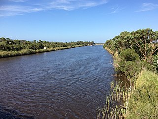
Stratford is a town on the Avon River in Victoria, Australia, 232 kilometres (144 mi) east of Melbourne on the Princes Highway in Shire of Wellington. At the 2016 census, Stratford had a population of 2617. The town services the local regional community and travellers on the Princes Highway. Stratford's principal industries are dairying, sheep, cattle and horse breeding and vegetable crops. The town has numerous coffee shops and cafes, a cellar door for a local winery, Design Gallery, model railway shop, a pub, parks and playgrounds for car travelers to break their journey.

<span class="mw-page-title-main">Mitchell River (Victoria)</span> River in Victoria, Australia

The Mitchell River is a perennial river of the East Gippsland catchment, located in the Australian state of Victoria. The unregulated river provides a unique example of riparian ecology, flowing generally south with the catchment area drawing from the steep mountains of the Victorian Alps to enter Lake King, one of the Gippsland Lakes, and then empty into the Bass Strait.

<span class="mw-page-title-main">Thomson River (Victoria)</span> River in Victoria, Australia

The Thomson River, a perennial river of the West Gippsland catchment, is located in the Gippsland region of the Australian state of Victoria.

<span class="mw-page-title-main">Latrobe River</span> River in Victoria, Australia

The Latrobe River is a perennial river of the West Gippsland catchment, located in the West Gippsland region of the Australian state of Victoria. The Latrobe River and its associated sub-catchment is an important source for the Gippsland Lakes, draining the south eastern slopes of the Great Dividing Range.

<span class="mw-page-title-main">Tambo River (Victoria)</span> River in Victoria, Australia

The Tambo River or Berrawan is a perennial river of the Mitchell River catchment, located in the East Gippsland region of the Australian state of Victoria. With a total length in excess of 186 kilometres (116 mi), the Tambo River is one of the longest rivers in the East Gippsland drainage basin, extending from the steep forested southern slopes of the Victorian Alps through forest and farmland to the Gippsland Lakes.

The Albert River is a perennial river of the West Gippsland catchment, located in the South Gippsland region of the Australian state of Victoria.

<span class="mw-page-title-main">Macalister River</span> River in Victoria, Australia

The Macalister River, a perennial river of the West Gippsland catchment, is located in the Alpine and Gippsland regions of the Australian state of Victoria.

The Perry River is a perennial river of the West Gippsland catchment, located in the Gippsland region of the Australian state of Victoria.

<span class="mw-page-title-main">Brodribb River</span> River in Victoria, Australia

The Brodribb River is a perennial river of the Snowy River catchment, located in the East Gippsland region of the Australian state of Victoria.

The Crooked River is a perennial river of the Mitchell River catchment, located in the Alpine region of the Australian state of Victoria.

The Turton River is a perennial river of the West Gippsland catchment, located in the Gippsland region of the Australian state of Victoria.

<span class="mw-page-title-main">Aberfeldy River</span> River in Victoria, Australia

The Aberfeldy River is a perennial river of the West Gippsland catchment, located in the Alpine region of the Australian state of Victoria.

The Caledonia River is a perennial river of the West Gippsland catchment, located in the Alpine region of the Australian state of Victoria.

The Tanjil River is a perennial river of the West Gippsland catchment, located in the West Gippsland region of the Australian state of Victoria.

The Wellington River is a perennial river of the West Gippsland catchment, located in the Alpine region of the Australian state of Victoria.

The Carey River is a perennial river of the West Gippsland catchment, located in the Alpine region of the Australian state of Victoria.

The Dolodrook River is a perennial river of the West Gippsland catchment, located in the Alpine region of the Australian state of Victoria.

The Little River is a perennial river of the West Gippsland catchment, located in the alpine region of the Australian state of Victoria.

References

  1. 1 2 Reed, A. W. (1973). Place names of Australia. Frenchs Forest: Reed Books. p. 19. ISBN   0-589-50128-3.
  2. 1 2 Blake, Les (1977). Place names of Victoria. Adelaide: Rigby. p. 294. ISBN   0-7270-0250-3., cited in Bird (2006)
  3. Bird, Eric (12 October 2006). "Place Names on the Coast of Victoria" (PDF). The Australian National Placename Survey (ANPS). Archived from the original (PDF) on 18 February 2011.
  4. 1 2 "Avon River: 9616: Traditional Name: Dooyeedang". Vicnames. Government of Victoria. 12 May 2011. Archived from the original on 22 February 2014. Retrieved 8 February 2014.
  5. 1 2 "Avon River: 9616: Traditional Name: Dooyeedang". Vicnames. Government of Victoria. 12 August 2011. Archived from the original on 22 February 2014. Retrieved 8 February 2014.
  6. 1 2 "Avon River: 9616: Traditional Name: Kutbuntaura-wurk". Vicnames. Government of Victoria. 12 August 2011. Archived from the original on 22 February 2014. Retrieved 8 February 2014.
  7. "Avon River: 9616". Vicnames. Government of Victoria. 2 May 1966. Archived from the original on 22 February 2014. Retrieved 8 February 2014.
  8. 1 2 "Map of Avon River, VIC". Bonzle Digital Atlas of Australia. Retrieved 8 February 2014.
  9. "Alpine National Park: Our Mountain Heritage - around Heyfield, Licola and Dargo in the Wonnangatta - Moroka area" (PDF). Parks Victoria . Government of Victoria. August 2012. Archived from the original (PDF) on 31 March 2012. Retrieved 8 February 2014.
  10. Close, David Kyhber (2021). BUCKLEY, BATMAN & MYNDIE: Echoes of the Victorian culture-clash frontier: Sounding 1: Before 1840 and Sounding 2: Dispossession At Melbourne. BookPOD. p. 97-4. ISBN   9780992290405 . Retrieved 2 November 2021.