Crooked River (Victoria)

Last updated

Crooked
Australia Victoria relief location map.jpg
Red pog.svg
Location of the Crooked River mouth in Victoria
Native name
Location
Country Australia
State Victoria
Region Australian Alps (IBRA), Victorian Alps
Local government area Shire of Wellington
Physical characteristics
Source confluenceTwenty Five Mile Creek and Thirty Mile Creek
  locationsouth of Dinner Plain, Great Dividing Range
  coordinates 37°15′1″S148°8′22″E / 37.25028°S 148.13944°E / -37.25028; 148.13944
  elevation653 m (2,142 ft)
Mouth confluence with the Wongungarra River
  location
Alpine National Park
  coordinates
37°21′28″S147°4′36″E / 37.35778°S 147.07667°E / -37.35778; 147.07667 Coordinates: 37°21′28″S147°4′36″E / 37.35778°S 147.07667°E / -37.35778; 147.07667
  elevation
287 m (942 ft)
Length26 km (16 mi)
Basin features
River system Mitchell River catchment
Tributaries 
  leftGood Luck Creek
  rightBrewery Creek (Victoria)
National park Alpine NP
[4] [5]

The Crooked River is a perennial river of the Mitchell River catchment, located in the Alpine region of the Australian state of Victoria.

Contents

Location and features

Formed by the confluence of the Twenty Five Mile Creek and Thirty Mile Creek, the Crooked River rises below The Tablelands, the fourth highest mountain pass in Victoria, [6] within the Great Dividing Range, south of Dinner Plain. The river flows in a highly meandering course, generally south by west, joined by two minor tributaries before reaching its confluence with the Wongungarra River between the small settlements of Howittville and Winchester, within the Alpine National Park in the Shire of Wellington. The river descends 366 metres (1,201 ft) over its 26-kilometre (16 mi) course. [5]

Etymology

In the Australian Aboriginal Brabralung dialect of the Gunai language, two variant names for the Crooked River are given as Dow-wirra, meaning "dry tree"; [1] [2] and Nirlung, meaning "plenty of water-hens". [3]

See also

Related Research Articles

<span class="mw-page-title-main">Mitchell River (Victoria)</span> River in Victoria, Australia

The Mitchell River is a perennial river of the East Gippsland catchment, located in the Australian state of Victoria. The unregulated river provides a unique example of riparian ecology, flowing generally south with the catchment area drawing from the steep mountains of the Victorian Alps to enter Lake King, one of the Gippsland Lakes, and then empty into the Bass Strait.

<span class="mw-page-title-main">Suggan Buggan River</span> River in Victoria, Australia

The Suggan Buggan River is a perennial river of the Snowy River catchment, located in the Alpine region of the Australian state of Victoria.

<span class="mw-page-title-main">Nicholson River (Victoria)</span> River in Victoria, Australia

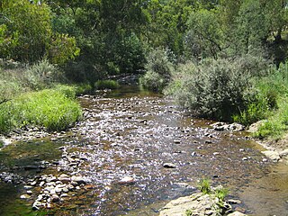
The Nicholson River is a perennial river of the Mitchell River catchment, located in the East Gippsland region of the Australian state of Victoria.

The Hartland River is a perennial river of the East Gippsland catchment, located in the Australian state of Victoria.

The Yeerung River is a perennial river located in the East Gippsland region of the Australian state of Victoria.

The Dargo River is a perennial river of the Mitchell River catchment, located in the Alpine and East Gippsland regions of the Australian state of Victoria.

The Wentworth River is a perennial river of the Mitchell River catchment, located in the East Gippsland region of the Australian state of Victoria.

<span class="mw-page-title-main">Moroka River</span> River in Victoria, Australia

The Moroka River is a perennial river of the Mitchell River catchment, located in the Alpine region of the Australian state of Victoria.

The Little Yalmy River is a perennial river of the Snowy River catchment, located in the Alpine region of the Australian state of Victoria.

<span class="mw-page-title-main">Berrima River</span> River in Victoria, Australia

The Berrima River, also called the Berrima Creek, is a perennial river of the Snowy River catchment, located in the Alpine region of the Australian states of New South Wales and Victoria.

The Little River is a perennial river of the Mitchell River catchment, located in the East Gippsland region of the Australian state of Victoria.

The Wonnangatta River is a perennial river of the Mitchell River catchment, located in the Alpine and East Gippsland regions of the Australian state of Victoria.

Swamp Creek is a perennial stream of the Mitchell River catchment, located in the Alpine and East Gippsland regions of the Australian state of Victoria.

The Little Dargo River is a perennial river of the Mitchell River catchment, located in the Alpine region of the Australian state of Victoria.

The Dry River is a perennial river of the Mitchell River catchment, located in the Alpine region of the Australian state of Victoria.

The Little River is a perennial river of the Mitchell River catchment, located in the Alpine region of the Australian state of Victoria.

The Humffray River is a perennial river of the Mitchell River catchment, located in the Alpine region of the Australian state of Victoria.

The Wongungarra River is a perennial river of the Mitchell River catchment, located in the Alpine region of the Australian state of Victoria.

<span class="mw-page-title-main">Aberfeldy River</span> River in Victoria, Australia

The Aberfeldy River is a perennial river of the West Gippsland catchment, located in the Alpine region of the Australian state of Victoria.

The Little River is a perennial river of the West Gippsland catchment, located in the Alpine region of the Australian state of Victoria.

References

  1. 1 2 "Crooked River: Traditional Name: Dow-wirra". Vicnames. Government of Victoria. 12 May 2011. Archived from the original on 2 February 2014. Retrieved 31 January 2014.
  2. 1 2 "Crooked River: Traditional Name: Dow-wirra". Vicnames. Government of Victoria. 12 August 2011. Archived from the original on 2 February 2014. Retrieved 31 January 2014.
  3. 1 2 "Crooked River: Traditional Name: Nirlung". Vicnames. Government of Victoria. 12 August 2011. Archived from the original on 2 February 2014. Retrieved 31 January 2014.
  4. "Crooked River: 13721". Vicnames. Government of Victoria. 2 May 1966. Archived from the original on 2 February 2014. Retrieved 31 January 2014.
  5. 1 2 "Map of Crooked River, VIC". Bonzle Digital Atlas of Australia. Retrieved 31 January 2014.
  6. "Map of The Tablelands, VIC". Bonzle Digital Atlas of Australia. Retrieved 31 January 2014.