Hopkins River

Last updated

Hopkins
The Hopkins Falls C1993.JPG
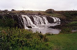
Hopkins Falls, near Wangoom, in 1993
Australia Victoria relief location map.jpg
Red pog.svg
Location of the Hopkins River mouth in Victoria
EtymologyIn honour of Sir John Paul Hopkins. [1] [2] [3]
Location
Country Australia
State Victoria
Region Victorian Midlands (IBRA), Western District
Local government area Moyne Shire, Warrnambool
Physical characteristics
Source 
  locationnear Ararat
  coordinates 38°0′54″S142°8′15″E / 38.01500°S 142.13750°E / -38.01500; 142.13750
  elevation338 m (1,109 ft)
Mouth Southern Ocean
  location
Warrnambool
  coordinates
38°24′9″S142°30′29″E / 38.40250°S 142.50806°E / -38.40250; 142.50806 Coordinates: 38°24′9″S142°30′29″E / 38.40250°S 142.50806°E / -38.40250; 142.50806
  elevation
0 m (0 ft)
Length271 km (168 mi)
Basin features
River system Glenelg Hopkins catchment
Tributaries 
  leftJacksons Creek (Moyne Shire, Victoria), Salt Creek (Moyne Shire, Victoria), Stony Creek (Moyne Shire, Victoria), Mount Emu Creek, Brucknell Creek
  rightBack Creek (Moyne Shire, Victoria), Reedy Creek (Moyne Shire, Victoria), Bushy Creek (Moyne Shire, Victoria), Back Creek, Two (Moyne Shire, Victoria), Chirrup Creek, Grays Creek, Mustons Creek
Waterfall Hopkins Falls
[4]

The Hopkins River, a perennial river of the Glenelg Hopkins catchment, is located in the Western District of Victoria, Australia.

Contents

Course and features

The Hopkins River rises below Telegraph Hill near Ararat, and flows generally south, joined by twelve tributaries including the Mount Emu Creek, before reaching its mouth and emptying into Bass Strait at Warrnambool. The river descends 338 metres (1,109 ft) over its 271-kilometre (168 mi) course. [4] The river and its tributaries drain much of Lake Bolac; and north of Allansford the river descends over the 11–13-metre (36–43 ft) Hopkins Falls. [5]

Together with the Merri River, the Hopkins flows through the regional centre of Warrnambool; and the river passes by the end of the Great Ocean Road near Allansford. [4]

River health

The Hopkins River is in extremely poor health with less than 5% of the river having natural bush and vegetation.

Re-vegetation

The Hopkins River Re-vegetation Project (HRRP) was commenced in 2016 by the Ellerslie Residents Group Inc.

Phase 1

Phase 1 of the HRRP project commenced in 2016 in Ellerslie. The Project is located between the Hopkins Highway bridge and the historic bridge.

Phase 2 & 3

Phases 2 & 3 of the project are planned to take place on the eastern bank between the phase 1 site and the Stony Creek Junction.

Etymology

The river was named in 1836 by Major Thomas Mitchell after a friend, Sir John Paul Hopkins. [1] [2] [3]

Related Research Articles

<span class="mw-page-title-main">Moyne River</span> River in Victoria, Australia

The Moyne River, a perennial river of the Glenelg Hopkins catchment, is located in the Western District of Victoria, Australia.

<span class="mw-page-title-main">Glenelg River (Victoria)</span> River in South Australia, Australia

The Glenelg River, a perennial river of the Glenelg Hopkins catchment, is located in the Australian states of Victoria and South Australia.

<span class="mw-page-title-main">Woady Yaloak River</span> Perennial river in Victoria, Australia

The Woady Yaloak River is a perennial river of the Corangamite catchment, located in the Western District Lakes region of the Australian state of Victoria.

<span class="mw-page-title-main">Wannon River</span> River in Victoria, Australia

The Wannon River, a perennial river of the Glenelg Hopkins catchment, is located in the Western District of Victoria, Australia.

The Fitzroy River, a perennial river of the Glenelg Hopkins catchment, is located in the Western District of Victoria, Australia.

<span class="mw-page-title-main">Mount Emu Creek</span> River in Victoria, Australia

The Mount Emu Creek, a perennial creek of the Glenelg Hopkins catchment, is located in the Western District of Victoria, Australia.

The Merri River, a perennial river of the Glenelg Hopkins catchment, is located in the Western District of Victoria, Australia.

The Shaw River, a perennial river of the Glenelg Hopkins catchment, is located in the Western District of Victoria, Australia.

The Surry River, sometimes incorrectly spelled as the Surrey River, a perennial river of the Glenelg Hopkins catchment, is located in the Western District of Victoria, Australia.

The Eumeralla River is a perennial river of the Glenelg Hopkins catchment, located in the Western District of Victoria, Australia.

The Hartland River is a perennial river of the East Gippsland catchment, located in the Australian state of Victoria.

<span class="mw-page-title-main">Moroka River</span> River in Victoria, Australia

The Moroka River is a perennial river of the Mitchell River catchment, located in the Alpine region of the Australian state of Victoria.

The Wonnangatta River is a perennial river of the Mitchell River catchment, located in the Alpine and East Gippsland regions of the Australian state of Victoria.

The Crooked River is a perennial river of the Mitchell River catchment, located in the Alpine region of the Australian state of Victoria.

The Crawford River or Smoky River, a perennial river of the Glenelg Hopkins catchment, is located in the Western District of Victoria, Australia.

The Wando River, a perennial river of the Glenelg Hopkins catchment, is located in the Western District of Victoria, Australia.

The Dundas River, a perennial river of the Glenelg Hopkins catchment, is located in the Western District of Victoria, Australia.

The Chetwynd River, a perennial river of the Glenelg Hopkins catchment, is located in the Western District of Victoria, Australia.

The Stokes River, a perennial river of the Glenelg Hopkins catchment, is located in the Western District of Victoria, Australia.

<span class="mw-page-title-main">Steavenson River</span> River in Victoria, Australia

The Steavenson River, sometimes incorrectly referred to as Steavensons River, a minor inland perennial river of the Goulburn Broken catchment, part of the Murray-Darling basin, is located in the lower South Eastern Highlands bioregion and Northern Country/North Central regions of the Australian state of Victoria. The headwaters of the Steavenson River rise on the north–western slopes of the Yarra Ranges, below Mount Edgar and descend to flow into the Acheron River near Buxton.

References

  1. 1 2 Mitchell, Thomas (1838). "Three Expeditions into the interior of Eastern Australia". London: Boone.
  2. 1 2 Reed, A. W. (1973). Place names of Australia. Frenchs Forest: Reed Books. ISBN   0-7301-0051-0.
  3. 1 2 Bird, Eric (12 October 2006). "Place Names on the Coast of Victoria" (PDF) (PDF). Australian National Placename Survey (ANPS). Archived from the original (PDF) on 18 February 2011. Retrieved 10 February 2011.
  4. 1 2 3 "Map of Hopkins River, VIC". Bonzle Digital Atlas of Australia. Retrieved 20 June 2014.
  5. "Map of Hopkins Falls, VIC". Bonzle Digital Atlas of Australia. Retrieved 20 June 2014.