Moorabool River

Last updated

Moorabool River
MooraboolRiver.JPG
The Moorabool River, between Steiglitz and Meredith
Location
Country Australia
State Victoria
City Geelong
Physical characteristics
Source Moorabool Reservoir, near Ballarat
  location Australia
  coordinates 37°30′33″S144°5′0″E / 37.50917°S 144.08333°E / -37.50917; 144.08333
Mouth confluence with Barwon River at Fyansford
  location
Australia
  coordinates
38°8′39″S144°18′54″E / 38.14417°S 144.31500°E / -38.14417; 144.31500
Length160 kilometres [1]
Basin features
Tributaries 
  right Lal Lal Creek

The Moorabool River is a river in Victoria, Australia, which runs for 160 kilometres [1] through several small towns such as Meredith, Anakie, and Staughton Vale. It runs into the Barwon River at Fyansford. It is believed that the name Moorabool derives from an Aboriginal word meaning the cry of a curlew or a ghost. [2]

Contents

Bridges

Bluestone bridge over the Moorabool on Yendon-Egerton Road Bluestone bridge on Yendon Egerton Road.jpg
Bluestone bridge over the Moorabool on Yendon-Egerton Road
The Moorabool River, at Batesford, 1882 MooraboolRiver BatesfordVictoria.jpg
The Moorabool River, at Batesford, 1882
Bridge at Fyansford, 1908 Fyansford Geelong1908.jpg
Bridge at Fyansford, 1908

The river features several historic bridges, many built of bluestone in the 19th century.

Batesford Bridge

Batesford was originally the site of a ford crossing the Moorabool River. The first bridge was built by the Corio and Bannockburn shire councils in 1846. Provided with a tollgate, the wooden bridge was located upstream from the ford, but collapsed in 1847. Rebuilt in wood in 1848, it was damaged by flood in 1852 and later repaired. A bluestone bridge was built in 1859, which still exists today as a service road. The current concrete bridge on the Midland Highway was built on a new alignment in 1972. [3]

Fyansford Bridge

The first river crossing at Fyansford was again a ford. The first wooden bridge was built by the Shire of Corio and Shire of Bannockburn in 1854, down river from the ford, and was tolled until 1877. It was in poor condition by 1898, with load restrictions being put into place. A new bridge was built nearby in 1900 by John Monash and J. T. N. Anderson, the three-arch bridge being the largest Monier reinforced concrete bridge in world at the time. [3]

In 1970, a new bridge was built on the site of the old wooden bridge to cater for heavier traffic on the Hamilton Highway, with the 1900 bridge being retained for pedestrians. [3]

Geelong Ring Road

Work on the Geelong Ring Road bridge over the Moorabool River commenced in late 2006. Costing $15.5 million, [4] it carries four lanes of traffic and is the largest bridge on the road, with 70 beams and 12 piers. The final span was installed on 6 March 2008. [5] It has been named the Lewis Bandt Bridge. [6]

Moorabool Viaduct

The 440-metre (1,440 ft)-long bluestone and iron Moorabool Viaduct was opened in 1862 to carry the Geelong-Ballarat railway over the river valley. It remains in use today, having been reinforced with extra steel piers in 1918, to a design of Victorian Railways engineer Frederick Esling. [7] [8]

Related Research Articles

<span class="mw-page-title-main">Geelong</span> City in Victoria, Australia

Geelong is a port city in Victoria, Australia, located at the eastern end of Corio Bay and the left bank of Barwon River, about 65 km (40 mi) southwest of Melbourne.

<span class="mw-page-title-main">City of Greater Geelong</span> Local government area in Victoria, Australia

The City of Greater Geelong is a local government area in the Barwon South West region of Victoria, Australia, located in the western part of the state. It covers an area of 1,248 square kilometres (482 sq mi) and, had a population of 271,057 as of the 2021 Australian census. It is primarily urban with the vast majority of its population living in the Greater Geelong urban area, while other significant settlements within the LGA include Anakie, Balliang, Barwon Heads, Batesford, Ceres, Clifton Springs, Drysdale, Lara, Ocean Grove, Portarlington and St Leonards. It was formed in 1993 from the amalgamation of the Rural City of Bellarine, Shire of Corio, City of Geelong, City of Geelong West, City of Newtown, City of South Barwon, and parts of Shire of Barrabool and Shire of Bannockburn.

<span class="mw-page-title-main">Barwon River (Victoria)</span> Perennial river in Victoria, Australia

The Barwon River is a perennial river of the Corangamite catchment, located in The Otways and the Bellarine Peninsula regions of the Australian state of Victoria.

This is a timeline of major events in the history of the city of Geelong, Australia.

<span class="mw-page-title-main">Fyansford, Victoria</span> Suburb of Geelong, Victoria, Australia

Fyansford is a township on the western edge of Geelong, Victoria, Australia, named after Captain Foster Fyans who came to Geelong as a Police magistrate in October, 1837. It is located at the junction of the Barwon and Moorabool rivers. At the 2016 census, Fyansford had a population of 196.

<span class="mw-page-title-main">Belmont, Victoria</span> Suburb of Geelong, Victoria, Australia

Belmont is a southern suburb of Geelong, Victoria, Australia. The name means "beautiful hill". Belmont is geographically separated from the Geelong central business district by the Barwon River. The suburb is primarily residential, with some light industry along Barwon Heads Road. The suburb is part of the City of Greater Geelong local government area. At the 2011 census, Belmont had a population of 13,616. It is also the home of champion junior mountain bike cyclist Luis Goldstraw, also known as Princess Louisa.

<span class="mw-page-title-main">Bannockburn, Victoria</span> Town in Victoria, Australia

Bannockburn is a town near Geelong, Victoria, Australia, 88 km southwest of Melbourne. It is located in Golden Plains Shire. In the 2021 census, Bannockburn had a population of 6,470.

<span class="mw-page-title-main">Meredith, Victoria</span> Town in Victoria, Australia

Meredith is a town in Victoria, Australia, located on the Midland Highway between Ballarat and Geelong, in the local government area of the Golden Plains Shire. At the 2016 census, Meredith had a population of 788.

<span class="mw-page-title-main">Geelong Ring Road</span> Freeway in Victoria, Australia

The Geelong Ring Road is a freeway ring road in Australia beside Geelong's western suburbs from the Princes Freeway at Corio to the Princes Highway at Waurn Ponds. It also connects to the Midland Highway towards Ballarat, and the Hamilton Highway.

<span class="mw-page-title-main">Inverleigh, Victoria</span> Town in Victoria, Australia

Inverleigh is a town in Victoria, Australia located 28 kilometres (17 mi) west from the City of Geelong and 87 kilometres (54 mi) from the state capital, Melbourne. The town is divided between Golden Plains Shire and Surf Coast Shire. In the 2021 census, the central area of Inverleigh had a population of 1,746. Inverleigh is known to be a popular stopover destination on the way to Lorne. The Inverleigh Hotel is very popular attracting customers from Geelong.

<span class="mw-page-title-main">Batesford, Victoria</span> Town in Victoria, Australia

Batesford is a town located approximately 10 kilometres west of Geelong and 67 kilometres south-west of the state capital, Melbourne.

The Geelong Racecourse is a major regional horse racing venue in Geelong, Victoria, Australia. The current racecourse dates to 1908. The annual Geelong Cup is held at the course every October, as well as a number of other race meets through the year.

<span class="mw-page-title-main">Warrnambool railway line</span> Railway line in Victoria, Australia

The Port Fairy railway line is a railway serving the south west of Victoria, Australia. Running from the western Melbourne suburb of Newport through the cities of Geelong and Warrnambool, the line once terminated at the coastal town of Port Fairy before being truncated to Dennington. This closed section of line has been converted into the 37 km long Port Fairy to Warrnambool Rail Trail. The line continues to see both passenger and freight services today.

The Geelong–Ballarat railway line is a broad-gauge railway in western Victoria, Australia between the cities of Geelong and Ballarat. Towns on the route include Bannockburn, Lethbridge, Meredith, Elaine and Lal Lal. Major traffic includes general freight from the Mildura line, and grain.

<span class="mw-page-title-main">Shire of Bannockburn</span> Local government area in Victoria, Australia

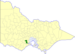
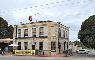
The Shire of Bannockburn was a local government area about 85 kilometres (53 mi) west-southwest of Melbourne, the state capital of Victoria, Australia. The shire covered an area of 702.28 square kilometres (271.2 sq mi), and existed from 1862 until 1994.

Edward Giles Stone was an Australian engineer prominent in many innovative, often daringly spectacular, aspects of early reinforced concrete constructions in Australia. He was also involved in cement manufacture. He was briefly a pioneer in prefab housing but that industry was destined to use timber, not concrete plates.

<span class="mw-page-title-main">Lewis Bandt Bridge</span> Bridge

The Lewis Bandt Bridge is an Australian feature bridge over the Moorabool River, close to the southern end of Stage 2 of the Geelong Ring Road.

<span class="mw-page-title-main">Railway tunnels in Victoria</span>

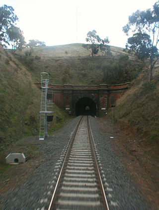
The Australian state of Victoria has only ever had about 10 tunnels on its railway network, with some others on private narrow gauge tramways. This is due to the relatively easy terrain through which most of the lines were built.

Edward Prowse was an architect working in the Geelong region of Victoria, Australia in the late nineteenth century. He was responsible for many early Geelong buildings, including hotels, mansions and churches.

<span class="mw-page-title-main">Shelford Bridge</span> Bridge in Victoria, Australia

The Shelford Bridge is an important early wrought iron box girder road bridge built in 1873-4 over the River Leigh and designed by Charles Anthony Corbett Wilson (1827–1923) on the main road from Melbourne to Portland in Victoria, Australia.

References

  1. 1 2 Webb, Carolyn (17 August 2021). "'The river is dying before our eyes': Campaigners fight to save the Moorabool". The Age. Retrieved 9 January 2024.
  2. "Moorabool Shire". Victorian Places. Retrieved 9 January 2024.
  3. 1 2 3 John, McNeil (1990) A Journey to Destiny 1890-1990 100 Years of Cement Manufacturing at Fyansford by Australian Cement Limited
  4. "GEELONG BYPASS SECTION 2 OFFICIALLY LAUNCHED". Media Release: MINISTER FOR PUBLIC TRANSPORT. www.legislation.vic.gov.au. 27 September 2006. Archived from the original on 16 June 2009. Retrieved 18 July 2008.
  5. Whalley, Jeff (7 March 2008). "MPs crane their necks to see the ring road milestone". The Geelong Advertiser. Archived from the original on 11 August 2008. Retrieved 18 July 2008.
  6. "Brumby Declares Geelong Ring Road Open". Geelong Advertiser. 14 December 2008. Archived from the original on 11 March 2012. Retrieved 16 April 2009.
  7. "Rail Geelong - Geelong Line Guide". www.railgeelong.com. Archived from the original on 1 December 2020. Retrieved 23 April 2008.
  8. "Rail Geelong - Gallery - Moorabool Viaduct". www.railgeelong.com. Archived from the original on 31 August 2009. Retrieved 5 September 2009.