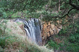
Werribee is a suburb in Melbourne, Victoria, Australia, 32 km (20 mi) south-west of Melbourne's Central Business District, located within the City of Wyndham local government area. Werribee recorded a population of 50,027 at the 2021 census.

The Avoca River, an inland intermittent river of the north–central catchment, part of the Murray-Darling basin, is located in the lower Riverina bioregion and Central Highlands and Wimmera regions of the Australian state of Victoria. The headwaters of the Avoca River rise on the northern slopes of the Pyrenees Range and descend to flow into the ephemeral Kerang Lakes.

Barwon Heads is a coastal township on the Bellarine Peninsula, near Geelong, Victoria, Australia. It is situated on the west bank of the mouth of the Barwon River below Lake Connewarre, while it is bounded to the west by farmland, golf courses and the ephemeral saline wetland Murtnaghurt Lagoon. At the 2016 census, Barwon Heads had a population of 3,875.

The Loddon River, an inland river of the north–central catchment, part of the Murray-Darling basin, is located in the lower Riverina bioregion and Central Highlands and Loddon Mallee regions of the Australian state of Victoria. The headwaters of the Loddon River rise on the northern slopes of the Great Dividing Range east of Daylesford and descend to flow north into the Little Murray River, near Swan Hill. The river is impounded by the Cairn Curran and Laanecoorie reservoirs. The Tullaroop Creek tributary which joins just above Laanecoorie Reservoir, is impounded by the Tullaroop Reservoir (72,950ML).
The Boonwurrung people are an Aboriginal people of the Kulin nation, who are the traditional owners of the land from the Werribee River to Wilsons Promontory in the Australian state of Victoria. Their territory includes part of what is now the city and suburbs of Melbourne. They were called the Western Port or Port Philip tribe by the early settlers, and were in alliance with other tribes in the Kulin nation, having particularly strong ties to the Wurundjeri people.

The Bellarine Peninsula is a peninsula located south-west of Melbourne in Victoria, Australia, surrounded by Port Phillip, Corio Bay and Bass Strait. The peninsula, together with the Mornington Peninsula, separates Port Phillip Bay from Bass Strait. The peninsula itself was originally occupied by Indigenous Australian clans of the Wathaurong nation, prior to European settlement in the early 19th century. Early European settlements were initially centred on wheat and grain agriculture, before the area became a popular tourist destination with most visitors arriving by paddle steamer on Port Phillip in the late 19th century.

The Werribee River is a perennial river of the Port Phillip catchment that is located on the expansive lowland plain southwest of Melbourne, Victoria, Australia. The headwaters of a tributary, the Lerderderg River, are north of Ballan near Daylesford and it flows across the basalt plain, through the suburb of Werribee to enter Port Phillip. A linear park follows the Werribee River along much of its course. In total the Werribee River completes a journey of approximately 110 kilometres (68 mi).
Alberton is a small town in Victoria, Australia. It is located along the South Gippsland Highway, 7 kilometres south of Yarram and 216 kilometres east of Melbourne. Albert River passes through the town. At the 2006 census, Alberton had a population of 162.

The Wimmera River, an inland intermittent river of the Wimmera catchment, is located in the Grampians and Wimmera regions of the Australian state of Victoria. Rising in the Pyrenees, on the northern slopes of the Great Dividing Range, the Wimmera River flows generally north by west and drains into Lake Hindmarsh and Lake Albacutya, a series of ephemeral lakes that, whilst they do not directly empty into a defined watercourse, form part of the Murray River catchment of the Murray-Darling basin.

The Coliban River, an inland perennial river of the north–central catchment, part of the Murray-Darling basin, is located in the lower Riverina bioregion and Central Highlands region of the Australian state of Victoria. The headwaters of the Coliban River rise on the northern slopes of the Great Dividing Range and descend to flow north into the Campaspe River with the impounded Lake Eppalock.
The Yalukit or Yalukit-willam people are a constituent clan of the Boonwurrung peoples. The Yalukit are the earliest Aboriginal inhabitants of the central bay-side region of Melbourne (Birrarung-ga). The Yalukit have inhabited the central bay-side areas of Melbourne for thousands of years.

Aboriginal Victorians, the Aboriginal Australians of Victoria, Australia, occupied the land for tens of thousands of years prior to European settlement. Aboriginal people have lived a semi-nomadic existence of fishing, hunting and gathering, and farming eels in Victoria for at least 40,000 years.
Ian D. Clark is an academic historian and Toponymist whose primary work has focused on Victorian Aboriginal history, aboriginal toponymy and the frontier conflict between Indigenous Australians and immigrant settlers during the European settlement of Victoria, Australia.

Wadawurrung, also rendered as Wathawurrung, Wathaurong or Wada wurrung, and formerly sometimes Barrabool, is the Aboriginal Australian language spoken by the Wathaurong people of the Kulin Nation of Central Victoria. It was spoken by 15 clans south of the Werribee River and the Bellarine Peninsula to Streatham. Glottolog classifies Wathawurrung as extinct, however various regional programs and initiatives promote the usage and revitalisation of Wathaurong language

The Campaspe River, an inland intermittent river of the north–central catchment, part of the Murray-Darling basin, is located in the lower Riverina bioregion and Central Highlands and Wimmera regions of the Australian state of Victoria. The headwaters of the Campaspe River rise on the northern slopes of the Great Dividing Range and descend to flow north into the Murray River, Australia's longest river, near Echuca.
The Avon River, an inland intermittent river of the Wimmera catchment, located in the Grampians and Wimmera regions of the Australian state of Victoria. Rising on the northern slopes of the Great Dividing Range, the Avon River flows north-westerly to reach its confluence with the Richardson River. The rivers of the Wimmera catchment drain into a series of ephemeral lakes that, whilst they do not directly empty into a defined watercourse, they form part of the Murray River catchment of the Murray-Darling basin.

The Richardson River, an inland intermittent river of the Wimmera catchment, located in the Grampians and Wimmera regions of the Australian state of Victoria. Rising on the northern slopes of the Great Dividing Range, the Richardson River flows generally north and drains in Lake Buloke, one of a series of ephemeral lakes that, whilst they do not directly empty into a defined watercourse, they form part of the Murray River catchment of the Murray-Darling basin.
The Mackenzie River, an inland intermittent river of the Wimmera catchment, is located in the Grampians region of the Australian state of Victoria. Rising in the Grampians National Park, on the northern slopes of the Great Dividing Range, the Mackenzie River flows generally north by west and drains into the Wimmera River, southwest of Horsham.
Lake Buloke is a eutrophic lake in the Wimmera region of north-western Victoria, Australia. The lake is fed by the Richardson River and is located adjacent to the township of Donald. Lake Buloke is also one of the most popular duck shooting lakes in Victoria. The Lake Buloke area comprises wetland habitat of high significance for waterbirds, particularly waterfowl and waders. The bull oak casuarina is found in the Shire and around Lake Buloke.
The Bunurong Land Council Aboriginal Corporation is a Registered Aboriginal Party and incorporated association representing the Bunurong community in the state of Victoria, Australia, particularly in matters relating to the Victorian Aboriginal Heritage Act 2006.


