Kororoit Creek

Last updated

Kororoit
Darter on Kororoit Creek, Albion.jpg
Kororoit Creek in Albion
Kororoitcreekmap.png
Contour map of the Kororoit Creek and its tributaries, in Greater Melbourne.
Etymology Aboriginal (Woiwurrung): creek on western plain [1]
Location
Country Australia
State Victoria
Region Victorian Midlands (IBRA), Greater Melbourne
Local government areas Melton, Brimbank
Suburbs Rockbank, Caroline Springs, Burnside, Kings Park, Albanvale, Deer Park, Cairnlea, West Sunshine, Ardeer, Albion, Brooklyn, Altona North
Physical characteristics
SourceMount Kororoit
  locationnortheast of Melton
  coordinates 37°38′21″S144°39′25″E / 37.63917°S 144.65694°E / -37.63917; 144.65694
  elevation407 m (1,335 ft)
Mouth Altona Bay, Port Phillip
  location
Altona North
  coordinates
37°51′46″S144°52′12″E / 37.86278°S 144.87000°E / -37.86278; 144.87000 Coordinates: 37°51′46″S144°52′12″E / 37.86278°S 144.87000°E / -37.86278; 144.87000
  elevation
0 m (0 ft)
Length52 km (32 mi)
Basin features
River system Port Phillip catchment
Tributaries 
  leftJones Creek (Cairnlea, Victoria)
National parks Altona Coastal Park, Jawbone Marine Sanctuary Park
[2] [3]

The Kororoit Creek is a watercourse of the Port Phillip catchment, rising in the outer north western suburbs of Melbourne, in the Australian state of Victoria.

Contents

Location and features

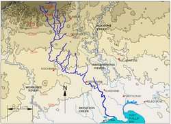
The Kororoit Creek rises below Mount Kororoit, northeast of Melton in the north western outer suburbs of Melbourne. The creek's headwaters are north of Sunbury at approximately 400 metres (1,300 ft) above sea level in ordovician geology. The creek flows generally south by east and passes over the volcanic lava plain of western Melbourne to its mouth at sea level, north of Altona and emptying into Altona Bay within Port Phillip. The creek is joined by one minor tributary as it descends approximately 407 metres (1,335 ft) over its 52-kilometre (32 mi) course. [3] At the outlet in Altona Bay, the creek winds its way through the Altona Coastal Park and then the Jawbone Marine Sanctuary Park, where it enters Port Phillip.

From east of Sunbury, the Kororoit Creek makes its way down through many suburbs towards its mouth, including the towns and suburbs of Rockbank, Caroline Springs, Burnside, Kings Park, Albanvale, Deer Park, Cairnlea, West Sunshine, Ardeer, Albion, Brooklyn and Altona North.

The creek is traversed by the Melton Highway, east of Melton; the Western Highway and the Western Ring Road, at Ardeer; and the West Gate Freeway and Federation Trail at Brooklyn. The Kororoit Creek Trail runs along the banks in the lower reaches of the creek.

History

The traditional custodians of the land surrounding the creek are the Wurundjeri people who had hunted, fished and camped along the creek for thousands of years. Aboriginal occupation is evident in the form of many scattered artefacts along the creek. Scar trees, where canoes were carved from the bark of the red gums, are dotted along the creek.[ citation needed ]

European explorers, James Flemming and Charles Grimes identified the Kororoit Creek in 1803,[ citation needed ] along with the Maribyrnong River and Yarra River.

The Brooklyn Bluestone Bridge was built over the Kororoit Creek at Brooklyn in the 1870s. The bridge was built using bluestone from the local area and still stands. The bridge was one of the first crossings built for gold diggers heading to the gold fields of Ballarat. [4]

Etymology

Kororoit is an Aboriginal word of the Woiwurrung language that has been used to describe the "creek on (the) western plain"; [1] with an alternate theory that claims the word to mean a "male kangaroo". [4]

Fauna

The creek is home to significant animal species such as the growling grass frog and the striped legless lizard, as well as migratory birds. Remnant native vegetation also survives in some places, including red river gum and white mangroves. Small parks are located on the east and west borders along the creek. Native reptiles, including tiger snake, eastern blue-tongued lizard, common snakeneck turtle and eastern brown snake were often seen along the creek. Unfortunately due to overdevelopment these species are now rarely seen in some areas. Reptiles found along the creek help to maintain the balance of the populations of small mammals such as water rats and mice that thrive along the banks of the creek. Native species of frogs have taken advantage and reclaimed residences in the new (man-made) wetlands and lakes. The eastern banjo frog, common eastern froglet and even the now endangered growling grass frog have been seen and heard in the new wetlands and around Kororoit Creek, particularly in Cairnlea. [5]

Aquatic species found in the creek include the common galaxias, short-finned eel, Australian smelt, tupong, common carp, eastern bluespot goby, and flathead gudgeon.[ citation needed ]

Bird species found adjacent to the creek include the Australasian darter, little pied cormorant, brown falcon, peregrine falcon, square-tailed kite, dusky moorhen, royal spoonbill, black swan, Pacific black duck, mallard, Australian wood duck, galah, rainbow lorikeet, white-faced heron, Australian white ibis, and wattlebird.[ citation needed ]

Both the river blackfish and the platypus are native species that are now believed to be extinct along creek's course.[ citation needed ]

Common introduced species that can be found adjacent to the creek include the red fox and the European rabbit.[ citation needed ]

See also

Related Research Articles

<span class="mw-page-title-main">City of Brimbank</span> Local government area in Victoria, Australia

The City of Brimbank is a local government area located within the metropolitan area of Melbourne, Victoria, Australia. It comprises the western suburbs between 10 and 20 km west and northwest from the Melbourne city centre.

<span class="mw-page-title-main">Maribyrnong River</span> River in Melbourne, Victoria, Australia

The Maribyrnong River is a perennial river of the Port Phillip catchment, located in the north–western suburbs of Melbourne, in the Australian state of Victoria.

<span class="mw-page-title-main">Burnside, Victoria</span> Suburb of Melbourne, Victoria, Australia

Burnside is a suburb in Melbourne, Victoria, Australia, 20 km (12 mi) west of Melbourne's Central Business District, located within the City of Melton local government area. Burnside recorded a population of 5,800 at the 2021 census.

<span class="mw-page-title-main">Caroline Springs, Victoria</span> Suburb of Melbourne, Victoria, Australia

Caroline Springs is a suburb in Melbourne, Victoria, Australia, 21 km (13 mi) west of Melbourne's Central Business District, located within the City of Melton local government area. Caroline Springs recorded a population of 24,488 at the 2021 census.

<span class="mw-page-title-main">Ardeer, Victoria</span> Suburb of Melbourne, Victoria, Australia

Ardeer is a suburb in Melbourne, Victoria, Australia, 15 km (9.3 mi) west of Melbourne's Central Business District, located within the City of Brimbank local government area. Ardeer recorded a population of 3,170 at the 2021 census.

<span class="mw-page-title-main">Deer Park, Victoria</span> Suburb of Melbourne, Victoria, Australia

Deer Park is a suburb in Melbourne, Victoria, Australia, 17 km (11 mi) west of Melbourne's Central Business District, located within the City of Brimbank local government area. Deer Park recorded a population of 18,145 at the 2021 census.

<span class="mw-page-title-main">St Albans, Victoria</span> Suburb of Melbourne, Victoria, Australia

St Albans is a suburb in Melbourne, Victoria, Australia, 17 km (11 mi) north-west of Melbourne's Central Business District, located within the City of Brimbank local government area. St Albans recorded a population of 38,042 at the 2021 census.

<span class="mw-page-title-main">Brooklyn, Victoria</span> Suburb of Melbourne, Victoria, Australia

Brooklyn is a suburb in Melbourne, Victoria, Australia, 10 km (6.2 mi) west of Melbourne's Central Business District, located within the Cities of Brimbank and Hobsons Bay local government areas. Brooklyn recorded a population of 1,979 at the 2021 census.

<span class="mw-page-title-main">Altona North, Victoria</span> Suburb of Melbourne, Victoria, Australia

Altona North is a suburb in Melbourne, Victoria, Australia, 10 km (6.2 mi) south-west of Melbourne's Central Business District, located within the City of Hobsons Bay local government area. Altona North recorded a population of 12,962 at the 2021 census.

<span class="mw-page-title-main">Cairnlea, Victoria</span> Suburb of Melbourne, Victoria, Australia

Cairnlea is a suburb in Melbourne, Victoria, Australia, 17 km (11 mi) north-west of Melbourne's Central Business District, located within the City of Brimbank local government area. Cairnlea recorded a population of 10,038 at the 2021 census.

<span class="mw-page-title-main">Parks and gardens of Melbourne</span> Parks and gardens in Melbourne, VIC, Australia

Melbourne is Australia's second largest city and widely considered to be a garden city, with Victoria being nicknamed "the Garden State". Renowned as one of the most livable cities in the world, there is an abundance of parks, gardens and green belts close to the CBD with a variety of common and rare plant species amid landscaped vistas, pedestrian pathways, and tree-lined avenues, all managed by Parks Victoria.

<span class="mw-page-title-main">Albion, Victoria</span> Suburb of Melbourne, Victoria, Australia

Albion is a suburb in Melbourne, Victoria, Australia, 14 km (8.7 mi) west of Melbourne's Central Business District, located within the City of Brimbank local government area. Albion recorded a population of 4,334 at the 2021 census.

<span class="mw-page-title-main">Albanvale, Victoria</span> Suburb of Melbourne, Victoria, Australia

Albanvale is a suburb in Melbourne, Victoria, Australia, 18 km (11 mi) north-west of Melbourne's Central Business District, located within the City of Brimbank local government area. Albanvale recorded a population of 5,641 at the 2021 census.

<span class="mw-page-title-main">Kororoit Creek Trail</span>

The Kororoit Creek Trail is a shared use path for cyclists and pedestrians, which follows the Kororoit Creek in the inner western suburbs of Melbourne, Victoria, Australia.

<span class="mw-page-title-main">Patterson River</span> River in Victoria, Australia

The Patterson River is a partly man-made urban river of the Port Phillip catchment in the Australian east coast state of Victoria, located in the outer southeastern suburbs of the Greater Melbourne region. Under the name "Patterson", it is the shortest river in Victoria at only 5 km (3.1 mi) in length, although its main stem tributary and de facto upper section, the Dandenong Creek, is over 53 km (33 mi) long.

<span class="mw-page-title-main">City of Sunshine</span> Local government area in Victoria, Australia

The City of Sunshine was a local government area about 13 kilometres (8 mi) west of Melbourne, the state capital of Victoria, Australia. The city covered an area of 80.05 square kilometres (30.91 sq mi), and existed from 1860 until 1994.

<span class="mw-page-title-main">Altona Coastal Park</span>

Altona Coastal Park, a 70 hectares intertidal and salt marsh area located 11 km from Melbourne CBD in the western suburb of Altona, is an important recreational and nature conservation area, providing habitats for a large biodiversity of flora and fauna. It is part of the Cheetham and Altona Important Bird Area.

<span class="mw-page-title-main">Geography of Melbourne</span>

Melbourne, the capital city of Victoria, Australia, is situated on the southeastern fringe of the Australian landmass and in the southern central part of the state. Melbourne covers an urbanised area of approximately 2,453 km²–larger than that of Sydney, Greater London and Mexico City, with population density roughly around 16 people per hectare on average.

<span class="mw-page-title-main">Electoral district of Laverton</span>

The Electoral district of Laverton is an electoral district of the Victorian Legislative Assembly in Australia. It was created in the redistribution of electoral boundaries in 2021, and came into effect at the 2022 Victorian state election.

References

  1. 1 2 "Kororoit Creek: 19025: Historical information". VICNAMES. Government of Victoria. 12 August 2012. Archived from the original on 16 April 2014. Retrieved 15 April 2014.
  2. "Kororoit Creek: 19025". VICNAMES. Government of Victoria. Archived from the original on 16 April 2014. Retrieved 15 April 2014.
  3. 1 2 "Map of Kororoit Creek, VIC". Bonzle Digital Atlas of Australia. Retrieved 15 April 2014.
  4. 1 2 "History". Friends of the Kororoit Creek. January 2008.
  5. "Kororoit Creek Regional Strategy 2005 - 2030". Victorian Government Land Channel. Victorian Department of Planning and Community Development. January 2008. Archived from the original on 13 September 2007. Retrieved 23 July 2009.