
The City of Wyndham is a local government area in Victoria, Australia in the outer south-western suburbs of Melbourne, within the Melbourne Metropolitan Area, between Melbourne and the regional city of Geelong. It has an area of 542 square kilometres (209 sq mi). The city had a population of 255,322 in June 2018. For the year to 2018 the City of Wyndham increased its population by 14,251, the largest number of any LGA in Victoria, as well as being the second most populous and the second fastest growing at a rate of 5.9 per cent.

Melton is a satellite city located 35 kilometres (22 mi) west from Melbourne CBD. It is the administrative centre of the City of Melton local government area and its most populous centre. At June 2019 Melton had an urban population of 72,177, and has grown steadily with an average annual rate of 5.01% year-on-year for the five years to 2019. It is considered part of the Greater Melbourne metropolitan area and is included in the capital's population statistical division.

The City of Melton is a local government area in Victoria, Australia, on Melbourne's western rural–urban fringe.

Melton South is a suburb in Melbourne, Victoria, Australia, 37 km (23 mi) west of Melbourne's Central Business District, located within the City of Melton local government area. Melton South recorded a population of 11,362 at the 2021 census.

Werribee is a suburb in Melbourne, Victoria, Australia, 32 km (20 mi) south-west of Melbourne's Central Business District, located within the City of Wyndham local government area. Werribee recorded a population of 50,027 at the 2021 census.
The Merri Creek is a waterway in southern parts of Victoria, Australia, which flows through the northern suburbs of Northcote. It begins near Wallan north of Melbourne and flows south for 70 km until it joins the Yarra River at Dights Falls. The area where the creek meets the river was traditionally the location for large gatherings of the Wurundjeri people and is suspected to have been the location for one of the earliest land treaties in Australia between Indigenous Australians and European settlers.

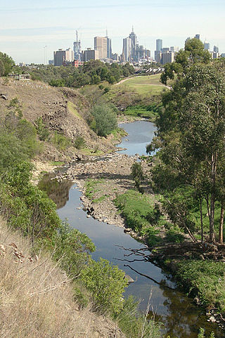
The Moonee Ponds Creek is a creek and major tributary of the Yarra River running through urban Melbourne, Victoria, Australia from northern to inner suburbs. In 2004 a reporter for The Age described it as "arguably the most abused tributary of the Yarra River, and part of the true underside of Melbourne".

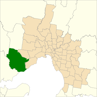
The Division of Gorton is an Australian Electoral Division in the state of Victoria.

Melbourne is Australia's second largest city and widely considered to be a garden city, with Victoria being nicknamed "the Garden State". Renowned as one of the most livable cities in the world, there is an abundance of parks, gardens and green belts close to the CBD with a variety of common and rare plant species amid landscaped vistas, pedestrian pathways, and tree-lined avenues, all managed by Parks Victoria.

Wyndham Vale is a suburb in Melbourne, Victoria, Australia, 31 km (19 mi) south-west of Melbourne's Central Business District, located within the City of Wyndham local government area. Wyndham Vale recorded a population of 20,518 at the 2021 census.

The Kororoit Creek is a watercourse of the Port Phillip catchment, rising in the outer north western suburbs of Melbourne, in the Australian state of Victoria.

Toolern Vale is a town in Victoria, Australia, 40 km (25 mi) north-west of Melbourne's Central Business District, located within the City of Melton and the Shire of Macedon Ranges local government areas. Toolern Vale recorded a population of 818 at the 2021 census.
The Werribee River Trail is a shared use path for cyclists and pedestrians, which follows Werribee River in the outer western suburb of Werribee in Melbourne, Victoria, Australia.
The electoral district of Werribee is an electoral district of the Legislative Assembly in the Australian state of Victoria. It has existed in two incarnations, first from 1976 to 2002, and was created again in the 2013 redistribution and came into effect at the 2014 state election.

Stony Creek is located in the western suburbs of Melbourne, Victoria, Australia. It runs through the suburbs of St Albans, Albion, Sunshine, Braybrook, Tottenham, Brooklyn, Kingsville and Yarraville.
Skeleton Waterholes Creek is a waterway in the outer western and outer south-western regions of Melbourne, Victoria. The creek originates near Mount Cottrell, to the south of Rockbank, and passes through rural land until it reaches the suburban areas of Tarneit, Truganina, Hoppers Crossing, Altona Meadows and Point Cook before it flows into Port Phillip Bay after the Cheetham Wetlands. The creek has important local Aboriginal spiritual significance, and parts of the creek are popular sites for recreation(various).
The western suburbs is the metropolitan area directly west of the Melbourne Central Business District in Melbourne, Victoria, Australia.

Cobblebank is a suburb in Melbourne, Victoria, Australia, 33 km (21 mi) west of Melbourne's Central Business District, located within the City of Melton local government area. Cobblebank recorded a population of 3,601 at the 2021 census.

Harkness is a suburb in Melbourne, Victoria, Australia, 38 km (24 mi) North west of Melbourne's Central Business District, located within the City of Melton local government area. Harkness recorded a population of 12,463 at the 2021 census.
