Amadi State

Last updated
Amadi State
Motto(s): 
Tribe(s) = Moru Sub tribes = Avokaya,Boŗiba,Kediro,Jur,Moru Ändri,Moru Doko,Moru Eji. Wadi,Nyamusa,Wira,Biti, Moru Miza
Amadi in South Sudan 2015.svg
Location of Amadi State in South Sudan
Country South Sudan
CapitalMundri [1]
Number of Counties3 [1]
Population
 (2014 Estimate)
  Total171,910

Amadi State was a state in South Sudan that existed between 2 October 2015 and 22 February 2020. [2] Amadi state formed from Western Equatoria state on 2 October 2015, following a decree that established the state along with 27 other states. It was located in the Equatoria region. Amadi State bordered Eastern Lakes State, Jubek State, Maridi State, Terekeka State, Western Lakes State, Yei River State. [3]

Contents

History

Before Sudan's 10 original states split into 28 separate states, Amadi was part of Western Equatoria state. On 2 October 2015, President Salva Kiir issued a decree establishing 28 states in place of the 10 constitutionally established states. [4] The decree established the new states largely along ethnic lines. A number of opposition parties and civil society groups challenged the constitutionality of the decree. Kiir later resolved to take it to parliament for approval as a constitutional amendment. [5] In November, the South Sudanese parliament empowered President Kiir to create new states. [6]

Joseph Ngere Paciko was the first and the current Governor of the state. [7]

Geography

Amadi State was located in the Equatoria region and it bordered Western Lakes to the northwest, Eastern Lakes to the northeast, Yei River to the south, Jubek to the southeast, Maridi to the west, and Terekeka to the east. [3]

Administrative divisions

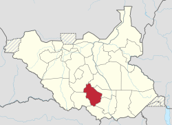
The state consisted of 3 counties. These three counties were Mundri West County, Mundri East County, and Mvolo County. [1]

Cities and towns

The capital of the state of Amadi was the city of Mundri, South Sudan. Mundri is located in Mundri West County, with an estimated population of 20,000-30,000 in 2015. [8] Other towns and villages in Amadi State include:

Related Research Articles

<span class="mw-page-title-main">Equatoria</span> Region in South Sudan

Equatoria is the southernmost region of South Sudan, along the upper reaches of the White Nile and the border between South Sudan and Uganda. Juba, the national capital and the largest city in South Sudan, is located in Equatoria. Originally a province of Anglo-Egyptian Sudan, it also contained most of northern parts of present-day Uganda, including Lake Albert and West Nile. It was an idealistic effort to create a model state in the interior of Africa that never consisted of more than a handful of adventurers and soldiers in isolated outposts.

<span class="mw-page-title-main">Central Equatoria</span> State of South Sudan

Central Equatoria is a state in South Sudan. With an area of 43,033 square kilometres (16,615 sq mi), it is the smallest of the original South Sudanese states. Its previous name was Bahr al-Jabal, named after a tributary of the White Nile that flows through the state. It was renamed Central Equatoria in the first Interim Legislative Assembly on 1 April 2005 under the government of Southern Sudan. Central Equatoria seceded from Sudan as part of the Republic of South Sudan on 9 July 2011. The state's capital, Juba, is also the national capital of South Sudan. On October 2, 2015, the state was split into three states: Jubek, Terekeka, and Yei River. The state of Central Equatoria was re-established by a peace agreement signed on 22 February 2020.

<span class="mw-page-title-main">Maridi</span> Place in South Sudan

Maridi is a town in South Sudan.

<span class="mw-page-title-main">States of South Sudan</span> First-level administrative division of South Sudan

The States of South Sudan were created out of the three historic former provinces of Bahr el Ghazal (northwest), Equatoria (southern), and Greater Upper Nile (northeast). The states are further divided into 79 counties.

<span class="mw-page-title-main">Juba County</span> County in Central Equatoria, South Sudan

Juba County is an administrative area in Central Equatoria state, South Sudan. It is the largest county in Central Equatoria and one of the largest in the region of Equatoria. Its county seat is Juba, the national capital of the South Sudan.

<span class="mw-page-title-main">Terekeka County</span> County in Central Equatoria, South Sudan

Terekeka County is an administrative division of Central Equatoria in South Sudan. It is the capital of surrounding Mundari and Boma counties. It lies on both the east and west bank of the White Nile north of Juba The word "Terekeka" is a combination of two words; "Tirgigi", a kind of hard shrub and "Terere" an open hard ground usually found in the middle of shrub trees. The local referral of "Terere i Tirgigi lukata" became shortened and distorted to create the current name, "Terekeka".

Terekeka is a community in Central Equatoria, South Sudan. It is the headquarters of Terekeka County.

<span class="mw-page-title-main">Eastern Lakes State</span> State of South Sudan from 2015 to 2020

Eastern Lakes State was a state in South Sudan that existed between 2 October 2015 and 22 February 2020. It was located in the Bahr el Ghazal region and it bordered Southern Liech to the north, Western States to the west, Amadi to the southwest, Terekeka to the southeast, and Jonglei to the east.

<span class="mw-page-title-main">Western Lakes State</span> State of South Sudan from 2015 to 2020

Western Lakes was a state in South Sudan that existed between 2 October 2015 and 22 February 2020. It was located in the Bahr el Ghazal region and was part of the former state of Lakes State. It bordered Amadi State, Eastern Lakes State, Gbudwe State, Gok, Maridi State, Southern Liech State, and Tonj State.

<span class="mw-page-title-main">Gbudwe State</span> State of South Sudan from 2015 to 2020

Gbudwe State was a state of South Sudan that existed between 2 October 2015 and 22 February 2020. It was created from Western Equatoria state. Tambura State was split from Gbudwe State on January 14, 2017. Gbudwe State was located in the Equatoria region. Gbudwe bordered the states of Lol, Maridi, Tambura, and Western Lakes, and also the province of Haut-Uélé in the Democratic Republic of the Congo and Haut-Mbomou in the Central African Republic. The state had a population of 364,272 in 2008.

<span class="mw-page-title-main">Imatong State</span> State of South Sudan from 2015 to 2020

Imatong State was a state in South Sudan that existed between 2 October 2015 and 22 February 2020. It was located in the Equatoria region and it bordered Yei River to the southwest, Jubek to the west, Terekeka and Jonglei to the northwest, Boma to the northeast, Namorunyang to the east, and Uganda to the south.

<span class="mw-page-title-main">Jubek State</span> 2015–2020 state in South Sudan

Jubek State was a state in South Sudan that existed between 2 October 2015 and 22 February 2020. It contained the national capital, Juba, which is also the largest city in South Sudan. The state bordered include Yei River county to the southwest, Amadi county to the west, Terekeka county to the north, and Imatong county to the east.

<span class="mw-page-title-main">Maridi State</span> State of South Sudan from 2015 to 2020

Maridi State was a state in South Sudan that existed between 2 October 2015 and 22 February 2020. It was formed on 2 October 2015 from Western Equatoria state. It was located in the Equatoria region. Maridi State bordered the states of Amadi State, Gbudwe State, Western Lakes State, and Yei River State.

<span class="mw-page-title-main">Terekeka State</span> State of South Sudan from 2015 to 2020

Terekeka State was a state in South Sudan that existed between 2 October 2015 and 22 February 2020. It was located in the Equatoria region and it bordered Amadi, Eastern Lakes, Imatong, Jonglei, and Jubek. It has an estimated population of 176,030 in 2014, and the capital and largest city of the state is Terekeka, South Sudan.

<span class="mw-page-title-main">Yei River State</span> State of South Sudan from 2015 to 2020

Yei River State was a state in South Sudan that existed from 2 October 2015 to 22 February 2020.

<span class="mw-page-title-main">Ruweng Administrative Area</span> Administrative area in South Sudan

The Ruweng Administrative Area is an administrative area in South Sudan. The area was known as Ruweng State between 2 October 2015 and 22 February 2020 when it was a state of South Sudan.

<span class="mw-page-title-main">Southern Liech State</span> State of South Sudan from 2015 to 2020

Southern Liech State was a state in South Sudan that existed between 2 October 2015 and 22 February 2020. It was located in the Greater Upper Nile region and it bordered Northern Liech to the north, Western Bieh to the east, Jonglei to the southeast, Eastern Lakes to the south, Western Lakes to the southwest, and Tonj to the west.

David Lokonga Moses has been the governor of Yei River State, South Sudan since 24 December 2015. He is the first governor of the state, which was created by President Salva Kiir on 2 October 2015.

<span class="mw-page-title-main">National Salvation Front (South Sudan)</span> Militant group in South Sudan

The National Salvation Front (NAS) is a South Sudanese militant group led by Thomas Cirillo which has been fighting against the government of South Sudan since March 2017.

This article lists events from the year 2019 in South Sudan

References

  1. 1 2 3 "Full list of Kiir's proposed new 28 states in S Sudan". Radio Tamazuj. 3 October 2015. Archived from the original on 5 March 2016. Retrieved 14 August 2016.
  2. Mutambo, Aggrey. "S. Sudan govt agrees to reduce states to 10 to maintain peace". The East African. Retrieved February 15, 2020.
  3. 1 2 "Amadi State". south-sudan.biz. Archived from the original on 27 November 2016. Retrieved 27 November 2016.
  4. "Kiir and Makuei want 28 states in South Sudan". Radio Tamazuj. Archived from the original on 2015-12-08.
  5. "Kiir pressured into taking decree to parliament for approval". Radio Tamazuj. Archived from the original on 2016-03-04.
  6. "South Sudan's Kiir appoints governors of 28 new states". Sudan Tribune.
  7. "Amadi State governor summons parliamentarians". Radio Tamazuj. 28 January 2016. Retrieved 14 August 2016.
  8. "DTM INFO Mundri East County Displacement Overview" (PDF). reliefweb.int. Retrieved 27 November 2016.
  9. "The Diocese of Lui in the Episcopal Church in South Sudan". lui.anglican.org. Retrieved 27 November 2016.