The States of South Sudan were created out of the three historic former provinces of Bahr el Ghazal (northwest), Equatoria (southern), and Greater Upper Nile (northeast). The states are further divided into 79 counties.

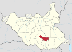
Terekeka County is an administrative division of Central Equatoria in South Sudan. It is the capital of surrounding Mundari and Boma counties. It lies on both the east and west bank of the White Nile north of Juba The word "Terekeka" is a combination of two words; "Tirgigi", a kind of hard shrub and "Terere" an open hard ground usually found in the middle of shrub trees. The local referral of "Terere i Tirgigi lukata" became shortened and distorted to create the current name, "Terekeka".
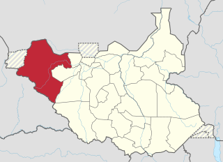
The Lol State was a state of South Sudan with the capital in Raga, that existed between 2 October 2015 and 22 February 2020. It was located in the Bahr el Ghazal region, which is in the northwest section of the country. Lol state bordered Haut-Mbomou and Haute-Kotto in the Central African Republic to the west, South Darfur and East Darfur in Sudan to the north, the disputed region of Kafia Kingi to the northwest, Aweil East State to the northeast, Aweil State to the east, Gbudwe State to the south, and Wau State to the southeast. The state was created alongside 27 other states after a decree issuing the creation of 28 states took place. It was dissolved at the conclusion of the South Sudanese Civil War.
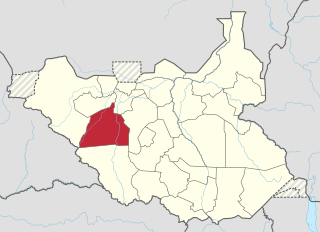
Wau State was a state in South Sudan that existed between 2 October 2015 and 22 February 2020. It was located in the Bahr el Ghazal region, and was part of the former state of Western Bahr el Ghazal. Wau State bordered Aweil State, Gbudwe State, Gogrial State, Lol State, and Tonj State.

Tonj State was a state in South Sudan that existed between 2 October 2015 and 22 February 2020. It was located in the Bahr el Ghazal region and it bordered Wau to the west, Gbudwe to the southwest, Gogrial to the northwest, Northern Liech to the northeast, Gok and Southern Liech to the east, and Western Lakes to the south and east.

Eastern Lakes State was a state in South Sudan that existed between 2 October 2015 and 22 February 2020. It was located in the Bahr el Ghazal region and it bordered Southern Liech to the north, Western States to the west, Amadi to the southwest, Terekeka to the southeast, and Jonglei to the east.

Western Lakes was a state in South Sudan that existed between 2 October 2015 and 22 February 2020. It was located in the Bahr el Ghazal region and was part of the former state of Lakes State. It bordered Amadi State, Eastern Lakes State, Gbudwe State, Gok, Maridi State, Southern Liech State, and Tonj State.

Amadi State was a state in South Sudan that existed between 2 October 2015 and 22 February 2020. Amadi state formed from Western Equatoria state on 2 October 2015, following a decree that established the state along with 27 other states. It was located in the Equatoria region. Amadi State bordered Eastern Lakes State, Jubek State, Maridi State, Terekeka State, Western Lakes State, Yei River State.

Gbudwe State was a state of South Sudan that existed between 2 October 2015 and 22 February 2020. It was created from Western Equatoria state. Tambura State was split from Gbudwe State on January 14, 2017. Gbudwe State was located in the Equatoria region. Gbudwe bordered the states of Lol, Maridi, Tambura, and Western Lakes, and also the province of Haut-Uélé in the Democratic Republic of the Congo and Haut-Mbomou in the Central African Republic. The state had a population of 364,272 in 2008.

Imatong State was a state in South Sudan that existed between 2 October 2015 and 22 February 2020. It was located in the Equatoria region and it bordered Yei River to the southwest, Jubek to the west, Terekeka and Jonglei to the northwest, Boma to the northeast, Namorunyang to the east, and Uganda to the south.

Jubek State was a state in South Sudan that existed between 2 October 2015 and 22 February 2020. It contained the national capital, Juba, which is also the largest city in South Sudan. The state bordered include Yei River county to the southwest, Amadi county to the west, Terekeka county to the north, and Imatong county to the east.

Maridi State was a state in South Sudan that existed between 2 October 2015 and 22 February 2020. It was formed on 2 October 2015 from Western Equatoria state. It was located in the Equatoria region. Maridi State bordered the states of Amadi State, Gbudwe State, Western Lakes State, and Yei River State.

Kapoeta State was a state in South Sudan that existed between 2 October 2015 and 22 February 2020. It was located in the Equatoria region and it bordered Imatong to the west, Boma to the north, Ethiopia to the east, and Kenya and Uganda to the south.

Yei River State was a state in South Sudan that existed from 2 October 2015 to 22 February 2020.

Boma State was a state in South Sudan that existed between 2 October 2015 and 22 February 2020. It was located in the Greater Upper Nile region and was formerly part of the state of Jonglei. The state bordered Akobo State, Imatong State, Jonglei State, Kapoeta State, Bieh State, Terekeka State and the country of Ethiopia to the east.

Bieh State was a state in South Sudan that existed between 2 October 2015 and 22 February 2020. It was located in the Greater Upper Nile region and it bordered Fangak to the west, Central Upper Nile to the north, Latjoor and Akobo to the east, and Jonglei to the south.

Latjoor was a state in South Sudan that existed between 2 October 2015 and 22 February 2020. It was located in the Greater Upper Nile region and it bordered Eastern Nile to the north, Eastern Bieh to the south, and Ethiopia to the east.

Eastern Nile was a state in South Sudan that existed between 2 October 2015 and 14 January 2017 when it was divided into Central Upper Nile State and Northern Upper Nile State. It was located in the Greater Upper Nile region and it was part of the former states of Upper Nile and Jonglei. The state bordered the states of Eastern Bieh, Latjoor, Western Bieh, Fashoda State, and the country of Ethiopia to the east.

Southern Liech State was a state in South Sudan that existed between 2 October 2015 and 22 February 2020. It was located in the Greater Upper Nile region and it bordered Northern Liech to the north, Western Bieh to the east, Jonglei to the southeast, Eastern Lakes to the south, Western Lakes to the southwest, and Tonj to the west.

Fangak State was a state in South Sudan that existed between 2 October 2015 and 22 February 2020. It was located in the Greater Upper Nile region and it bordered Ruweng to the northwest, Western Nile to the northeast, Eastern Nile to the east, Eastern Bieh to the southeast, Jonglei to the south, Southern Liech to the southwest, and Northern Liech to the west.