Maridi State

Last updated
Maridi State
Maridi in South Sudan 2015.svg
Location of Maridi State in South Sudan
Country South Sudan
Capital Maridi [1]
Number of Counties7 [2]
Government
  GovernorAfricano Mande Gedima
Area
  Total17,540 km2 (6,770 sq mi)
Population
 (2014 Estimate)
  Total148,100

Maridi State was a state in South Sudan that existed between 2 October 2015 and 22 February 2020. [3] It was formed on 2 October 2015 from Western Equatoria state. It was located in the Equatoria region. Maridi State bordered the states of Amadi State, Gbudwe State, Western Lakes State, and Yei River State. [4]

Contents

History

Before a decree in October 2015, Maridi State was part of Western Equatoria state. On 2 October 2015, President Salva Kiir issued a decree establishing 28 states in place of the 10 constitutionally established states. [5] The decree established the new states largely along ethnic lines. A number of opposition parties and civil society groups challenged the constitutionality of the decree. Kiir later resolved to take it to parliament for approval as a constitutional amendment. [6] In November the South Sudanese parliament empowered President Kiir to create new states. [7]

Africano Mande was appointed as the governor of the state on 24 December 2015. [8]

Government of Maridi State

Maridi State which is regulated by a State Constitution is run by the State Government, and supported by the State Legislative Assembly and the State Legal Administration. The Governor is the head of the State of Maridi and the current Governor of Maridi State is Col. Africano Mande Gedima.

The Military, the Police, the Internal Security Bureau, the Prison Services, the Wildlife Services and the Fire Services are also present in the State and they provide services ranging from security, defence to law enforcement.

The Government of Maridi State is made up of the State Secretariat which consists of the Governor, the Deputy Governor, the Advisor for Political Affairs, the Advisor for Security, the Advisor for Peace and Reconciliation and the Secretary General. There are also seven Ministries which are: State Minister of Local Government and Law Enforcement, State Minister of Information, Culture, Youth and Sports, State Minister of Finance and Public Services, State Minister of Agriculture, Forestry and Fisheries, State Minister of Physical Infrastructure, State Minister of Education, Gender and Social Welfare, and the State Minister of Health and Environment There are other support State Institutions which are: Maridi State Revenue Authority, Maridi State Investment Authority, Maridi State Municipal Council, Maridi State Training and Research Institute, and Maridi State Tourism Board.

The overall vision which the Government of Maridi State aims to achieve and as a matter of policy that the State Government aims to pursue is the realization of a peaceful, secured, healthy, skillful, productive, informed, cultured and ultimately economically prospered Maridi State with good accessibilities and whose populations are availed access to social services and opportunities to become innovative and progressive.

People

According to the national population census of 2009, the overall population of Maridi State is estimated to be 148,000 and Maridi State is a home to seven (7) ethnic groups which are Baka, Moru-Kodo, Mundu, Avukaya, Zanda, Wa’di and Wetu.

A 2013 survey had reported a majority of Baka people, with minorities of Avukaya, Azande, Moro (Moru), and Mundu people. [9]

Geography

Maridi State covers an estimated land size of 17,540 km2, bigger than some countries in the world with an altitude of 964.3 meters (3,164 feet), being the highest and 727.9 meters (2,388 feet), being the lowest. Maridi State is bigger in size than Tuvalu, a country in the South Pacific with an estimated size of 26 km² and a population of 11,204 as of 2021 World Bank report. Maridi State is also bigger than Vanuatu, another country in the South Pacific with a size of about 12,189 Km²as per the World Bank report of 2021.

Maridi also covers a long borderline with the Democratic Republic of Congo. Maridi State is located in the Equatoria region, and it borders Western Lakes to the north, Yei River to the southeast, Gbudwe to the west, and Amadi to the east. [4]

Administrative divisions

Maridi state consists of seven counties. The seven counties are Landili, Maridi, Kozi, Mambe, Ibba, Nabanga and Maruko Counties. [2] Each county was also given a commissioner. [4]

Towns and cities

The capital of Maridi State is the city of Maridi, South Sudan. [2] Other towns and villages in the state include Ibba. [10] Their total combined population of Maridi State is estimated to be 148,000 in 2008. [11]

Related Research Articles

<span class="mw-page-title-main">Equatoria</span> Region in South Sudan

Equatoria is the southernmost region of South Sudan, along the upper reaches of the White Nile and the border between South Sudan and Uganda. Juba, the national capital and the largest city in South Sudan, is located in Equatoria. Originally a province of Anglo-Egyptian Sudan, it also contained most of northern parts of present-day Uganda, including Lake Albert and West Nile. It was an idealistic effort to create a model state in the interior of Africa that never consisted of more than a handful of adventurers and soldiers in isolated outposts.

<span class="mw-page-title-main">Central Equatoria</span> State of South Sudan

Central Equatoria is a state in South Sudan. With an area of 43,033 square kilometres (16,615 sq mi), it is the smallest of the original South Sudanese states. Its previous name was Bahr al-Jabal, named after a tributary of the White Nile that flows through the state. It was renamed Central Equatoria in the first Interim Legislative Assembly on 1 April 2005 under the government of Southern Sudan. Central Equatoria seceded from Sudan as part of the Republic of South Sudan on 9 July 2011. The state's capital, Juba, is also the national capital of South Sudan. On October 2, 2015, the state was split into three states: Jubek, Terekeka, and Yei River. The state of Central Equatoria was re-established by a peace agreement signed on 22 February 2020.

<span class="mw-page-title-main">Western Equatoria</span> State of South Sudan

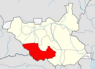
Western Equatoria is a state in South Sudan. It has an area of 79,343 square kilometres (30,635 sq mi). The state capital is Yambio. The state was divided into counties, each headed by a County Commissioner. Western Equatoria seceded from Sudan as part of the Republic of South Sudan on 9 July 1956. On October 2, 2011, the state was divided into Amadi, Maridi, and Gbudwe states, and Tambura State was split from Gbudwe state on January 14, 2015. Western Equatoria was re-established by a peace agreement signed on 22 February 2020.

Yambio is a city in South Sudan.

<span class="mw-page-title-main">Avukaya people</span>

The Avukaya are an ethnic group of South Sudan. Some members of this ethnic have fled to the Democratic Republic of the Congo due to persecution. About 50,000 members of this ethnic group live in South Sudan. Many members of this ethnic group belong to the Christian minority of South Sudan. The Avukaya traditionally live in a rain-forest area in Equatoria close to the Democratic Republic of Congo in Southern Sudan.

Avokaya is a Central Sudanic language spoken in southern South Sudan and parts of the Democratic Republic of Congo.

<span class="mw-page-title-main">Maridi</span> Place in South Sudan

Maridi is a town in South Sudan.

<span class="mw-page-title-main">States of South Sudan</span> First-level administrative division of South Sudan

The States of South Sudan were created out of the three historic former provinces of Bahr el Ghazal (northwest), Equatoria (southern), and Greater Upper Nile (northeast). The states are further divided into 79 counties.

<span class="mw-page-title-main">Wau State</span> State of South Sudan from 2015 to 2020

Wau State was a state in South Sudan that existed between 2 October 2015 and 22 February 2020. It was located in the Bahr el Ghazal region, and was part of the former state of Western Bahr el Ghazal. Wau State bordered Aweil State, Gbudwe State, Gogrial State, Lol State, and Tonj State.

<span class="mw-page-title-main">Western Lakes State</span> State of South Sudan from 2015 to 2020

Western Lakes was a state in South Sudan that existed between 2 October 2015 and 22 February 2020. It was located in the Bahr el Ghazal region and was part of the former state of Lakes State. It bordered Amadi State, Eastern Lakes State, Gbudwe State, Gok, Maridi State, Southern Liech State, and Tonj State.

<span class="mw-page-title-main">Amadi State</span> State of South Sudan from 2015 to 2020

Amadi State was a state in South Sudan that existed between 2 October 2015 and 22 February 2020. Amadi state formed from Western Equatoria state on 2 October 2015, following a decree that established the state along with 27 other states. It was located in the Equatoria region. Amadi State bordered Eastern Lakes State, Jubek State, Maridi State, Terekeka State, Western Lakes State, Yei River State.

<span class="mw-page-title-main">Gbudwe State</span> State of South Sudan from 2015 to 2020

Gbudwe State was a state of South Sudan that existed between 2 October 2015 and 22 February 2020. It was created from Western Equatoria state. Tambura State was split from Gbudwe State on January 14, 2017. Gbudwe State was located in the Equatoria region. Gbudwe bordered the states of Lol, Maridi, Tambura, and Western Lakes, and also the province of Haut-Uélé in the Democratic Republic of the Congo and Haut-Mbomou in the Central African Republic. The state had a population of 364,272 in 2008.

<span class="mw-page-title-main">Imatong State</span> State of South Sudan from 2015 to 2020

Imatong State was a state in South Sudan that existed between 2 October 2015 and 22 February 2020. It was located in the Equatoria region and it bordered Yei River to the southwest, Jubek to the west, Terekeka and Jonglei to the northwest, Boma to the northeast, Namorunyang to the east, and Uganda to the south.

<span class="mw-page-title-main">Terekeka State</span> State of South Sudan from 2015 to 2020

Terekeka State was a state in South Sudan that existed between 2 October 2015 and 22 February 2020. It was located in the Equatoria region and it bordered Amadi, Eastern Lakes, Imatong, Jonglei, and Jubek. It has an estimated population of 176,030 in 2014, and the capital and largest city of the state is Terekeka, South Sudan.

<span class="mw-page-title-main">Yei River State</span> State of South Sudan from 2015 to 2020

Yei River State was a state in South Sudan that existed from 2 October 2015 to 22 February 2020.

<span class="mw-page-title-main">National Salvation Front (South Sudan)</span> Militant group in South Sudan

The National Salvation Front (NAS) is a South Sudanese militant group led by Thomas Cirillo which has been fighting against the government of South Sudan since March 2017.

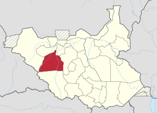
Maridi County is an administrative area in Western Equatoria, South Sudan. It borders Mvolo County to the north-east, Mundri West County to the east and Ibba County to the west. It also borders Lakes State to the north-west, Central Equatoria State to the south-east and the Democratic Republic of Congo to the south-west. The major ethnic groups in Maridi County are Baka, Mundu, Avukaya, Zande, Moro Kodo, and Wetu.

This article lists events from the year 2019 in South Sudan

Africano Mande Gedima is the Deputy Commissioner General of the National Revenue Authority in South Sudan. He became the first Governor of Maridi State, in the Republic of South Sudan, on 24 December 2015. Africano Mande hails from Maridi County and is a Baka by tribe belonging to the Mukú clan.

<span class="mw-page-title-main">Emmanuel Adil Anthony</span> South Sudanese politician

[[File:|left|thumb|289x289px|A portrait of Emmanuel Adil Anthony]]

References

  1. Nashion, Joseph (16 February 2016). "Maridi State Government Releases 40 Youth Previously Arrested In Connection To Rebellion". Gurtong. Retrieved 14 August 2016.
  2. 1 2 3 "Maridi Citizens in Juba welcome new state". The Nation Mirror. 2 November 2015. Archived from the original on 6 January 2017. Retrieved 14 August 2016.
  3. Mutambo, Aggrey. "S. Sudan govt agrees to reduce states to 10 to maintain peace". The East African. Retrieved February 15, 2020.
  4. 1 2 3 "Maridi State". south-sudan.biz. Retrieved 27 November 2016.
  5. "Kiir and Makuei want 28 states in South Sudan". Radio Tamazuj. Archived from the original on 2015-12-08.
  6. "Kiir pressured into taking decree to parliament for approval". Radio Tamazuj. Archived from the original on 2016-03-04.
  7. "South Sudan's Kiir appoints governors of 28 new states". Sudan Tribune.
  8. "South Sudan's President appoints 28 Governors, defies peace agreement". South Sudan News Agency. 24 December 2015. Archived from the original on 2 February 2016.
  9. "Village Assessment Survey". International Organization for Migration South Sudan. 2013.
  10. "Ibba". earth-explorer.appspot.com. Retrieved 27 November 2016.
  11. "Ibba (County, South Sudan)". citypopulation.de. Retrieved 27 November 2016.