Anavarza Castle

Last updated
Anavarza Castle
Adana Province, Turkey
Anavarza Castle.jpg
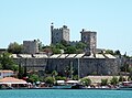
The castle from the west
Turkey adm location map.svg
Red pog.svg
Anavarza Castle
Coordinates 37°15′03″N35°53′50″E / 37.25083°N 35.89722°E / 37.25083; 35.89722 Coordinates: 37°15′03″N35°53′50″E / 37.25083°N 35.89722°E / 37.25083; 35.89722
TypeFortress
Site information
Open to
the public
Yes
ConditionRampart and the main building standing
Site history
Built by Roman Empire (?)
Armenian Kingdom of Cilicia
Crusaders
DemolishedPartially

Anvarza Castle is an ancient castle in Adana Province, Turkey.

Contents

Geography

The castle lies to the east of Dilekkaya village of Kozan district. Visitors follow Turkish state highway D.400 and the highway to north for 26 kilometres (16 mi) and turn to east for 6 kilometres (3.7 mi). Although the vicinity of the castle is Çukurova plains (Cilicia of the antiquity) which is almost flat, there is a hill with steep slopes of about 150 metres (490 ft) high with respect to plains. The castle was built on the hill. The hill is accessible via a path from the south.

History

The castle had been built[ when? ] to control the ancient city with the same name. The remains of the city (which is on the plains) lies between the village and the castle. The bird's flight distance between the remains and the castle is about 1 kilometre (0.62 mi). During the history the castle had switched hands and partially ruined several times (Roman Empire, Byzantine Empire, Abbasid Caliphate, Crusaders, Armenian Kingdom of Cilicia, Mamluks of Egypt etc.). Archaeological evidence indicates that the majority of the fortress is of Armenian construction, including the small basilica of T’oros I (AD 1111)[ clarification needed ] and the chapels. The donjon was built by the Crusaders in the 12th century. [1] Although the city was evacuated in 1274 following an earthquake [2] the castle was used by Mamluks.

Building

General view (c. 1860) LANGLOIS(1861) p507 - VUE DES RUINES D' ANAZARBE.jpg
General view (c. 1860)

The height of the rampart is about 8 metres (26 ft). The length of the rampart from north to south is about 1,500 metres (4,900 ft). There are 20 bastions. The east to west dimensions are much less than the length. The north bailey has not been surveyed. [2] The military quarters are confined to the south and central baileys, which are separated by the Crusader donjon. [1] [3] The castle can be visited free of charge. [2]

See also

Other castles in the region include:

Related Research Articles

<span class="mw-page-title-main">Anazarbus</span> Ancient Greek city in Anatolia

Anazarbus was an ancient Cilician city. Under the late Roman Empire, it was the capital of Cilicia Secunda. Roman emperor Justinian I rebuilt the city in 527 after a strong earthquake hit it. It was destroyed in 1374 by the forces of the Mamluk Empire, after their conquest of Cilician Armenia.

<span class="mw-page-title-main">Cilicia</span> Geographical region in Turkey

Cilicia is a geographical region in southern Anatolia in Turkey, extending inland from the northeastern coasts of the Mediterranean Sea. Cilicia has a population ranging over six million, concentrated mostly at the Cilicia plain. The region includes the provinces of Mersin, Adana, Osmaniye, along with parts of Hatay and Antalya.

<span class="mw-page-title-main">Kozan, Adana</span> City in Adana Province of Turkey

Kozan, formerly Sis, is a city in Adana Province, Turkey, 68 kilometres northeast of Adana, in the northern section of the Çukurova plain. The city is the capital of the ilçe (district) of Kozan. The Kilgen River, a tributary of the Ceyhan, flows through Kozan and crosses the plain south into the Mediterranean. The Taurus Mountains rise up sharply behind the town.

<span class="mw-page-title-main">Cilician Gates</span> Pass through the Taurus Mountains

The Cilician Gates or Gülek Pass is a pass through the Taurus Mountains connecting the low plains of Cilicia to the Anatolian Plateau, by way of the narrow gorge of the Gökoluk River. Its highest elevation is about 1000m.

Lampron is a castle near the town of Çamlıyayla in Mersin Province, Turkey. While part of the Armenian Kingdom of Cilicia in the Middle Ages, the castle was known as Lampron and was the ancestral home of the Armenian Hethumid princes. Situated in the Taurus Mountains, the fortress guarded passes to Tarsus and the Cilician Gates.

Düziçi is a town and district of Osmaniye Province in the Mediterranean region of Turkey. It is located in a small plain in the foothills of the Nur Mountains and 440 m above the sea level.

Toprakkale is a town and district of Osmaniye Province in the Mediterranean region of Turkey. It is located at 10 km to the west of Osmaniye. Its name comes from an Abbasid castle near the city.

<span class="mw-page-title-main">Yılankale</span> Castle ruin in Ceyhan, Adana, Turkey

Yılankale is a late 12th–13th century Armenian castle in Adana Province of Turkey. It is known in Armenian as Levonkla after its possible founder—King Leo (Levon) I the Magnificent of the Armenian Kingdom of Cilicia. Medieval Armenian names attached to the site are Kovara and Vaner.

<span class="mw-page-title-main">Sarvandikar</span>

Sarvandikar, also spelled Sarvanda k'ar. It was the Frankish castle of Savranda and is officially known today as Savranda Kalesi. The site is a medieval castle in the former Armenian Kingdom of Cilicia, located in Turkey's Osmaniye Province approximately 115 kilometers east of Adana.

<span class="mw-page-title-main">Sis (ancient city)</span> Ancient Armenian city

Sis was the capital of the Armenian Kingdom of Cilicia. The massive fortified complex is just to the southwest of the modern Turkish town of Kozan in Adana Province.

<span class="mw-page-title-main">Mamure Castle</span> Castle in Turkey

Mamure Castle is a medieval castle in the Bozdogan village, Anamur ilçe (district) of Mersin Province, Turkey.

<span class="mw-page-title-main">Silifke Castle</span>

Silifke Castle is a medieval castle in Turkey.

<span class="mw-page-title-main">Kızkalesi (castle)</span> Island castle in Mersin Province, southern Turkey

Kızkalesi is an island castle situated on a small island in Mersin Province of Turkey.

<span class="mw-page-title-main">Gözne Castle</span>

Gözne Castle is a medieval castle in Mersin Province, Turkey.

<span class="mw-page-title-main">Yaka Castle</span>

Yaka Castle is a castle ruin in Mersin Province, Turkey. Although its name is Güdübeş, it is popularly known as Yaka referring to a former village to the east of the castle.

<span class="mw-page-title-main">Bodrumkale</span> Castle in Osmaniye Province, Turkey

Bodrumkale is a castle ruin in Osmaniye Province, Turkey. It is situated on a hill, about 12 kilometres (7.5 mi) away from Osmaniye. The castle is to the northeast of the ancient city of Castabala. In medieval times it controlled the road from Central Anatolia to the Mediterranean coast. In 1973 an archaeological assessment and accurate plan were published. The castle is divided into two baileys or wards and has six towers. Most of its masonry was cut directly from the limestone outcrop and not plundered from the ancient city below. The lower level of the south tower functioned as a cistern. The survey was conducted under the auspices of the University of California at Berkeley.

<span class="mw-page-title-main">Tece Castle</span> Castle ruins in the Mersin

Tece Castle is a ruined castle in Mersin Province, southern Turkey.

<span class="mw-page-title-main">Kozan Castle</span>

Kozan Castle is a castle in Kozan, Adana Province, Turkey.

<span class="mw-page-title-main">Gülek Castle</span> Castle in the Mersin province, Turkey

Gülek Castle is a medieval castle in Mersin Province, Turkey.

<span class="mw-page-title-main">History of Cilicia</span>

Cilicia was one of the most important regions of the Middle East throughout history, who hosted the Hittite, Hellenistic, Roman, Armenian, and Islamic civilizations. Historically many people considered it as a part of the Levant, and during what is called the Rashidun Caliphate, much of its area was titled with the arabic name "Ath-Thugur As-Shamiyya"-carrying the meaning Levantine outskirts.

References

  1. 1 2 Edwards, Robert W. (1987). The Fortifications of Armenian Cilicia: Dumbarton Oaks Studies XXIII. Washington, D.C.: Dumbarton Oaks, Trustees for Harvard University. pp. 65–72, 281, pls. 9a-18b, 287b–289c. ISBN   0-88402-163-7.
  2. 1 2 3 Castles page Archived April 16, 2014, at the Wayback Machine
  3. Adana page (in Turkish)