Toprakkale (castle)

Last updated

Rusahinili ("city of (King) Rusa I)", modern Toprakkale (Turkey), is an ancient Urartian fortress built by Rusa I, located near the modern city of Van in eastern Turkey.

Offering table form the temple of Haldi. From Toprakkale, Van. 7th century BE. Museum of the Ancient Orient, Istanbul Offering table form the temple of Haldi. From Toprakkale, Van. 7th century BE. Museum of the Ancient Orient, Istanbul.jpg
Offering table form the temple of Haldi. From Toprakkale, Van. 7th century BE. Museum of the Ancient Orient, Istanbul

The site has been excavated by archaeological teams from Germany, the United Kingdom, and other countries.

Urartian Art Samples from Rusahinili - Toprakkale in Turkey
Hermitage Museum, Sankt Petersburg Rusahinili - Toprak-Kale, Turkey
Bronze sculpture of an Urartian godEngraving of the Urartian God Teisheba
Urartian Art 04b~.jpg Urartian Art 03.jpg Toprah-Kale.jpg
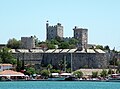
Left: Sculpture of an Urartian deity found at Rusahinili - Toprak-Kale, Turkey, (Hermitage Museum, Sankt Petersburg). Center: Engraving of Urartian Storm and War God Teisheba, which was acquired in Rusahinili - Toprak-Kale, Turkey (Hermitage Museum, Sankt Petersburg). Right: Rusahinili - Toprak-Kale, Turkey, which is located at the east of Modern Van City and Lake Van, named Rusahinili in honor of the king Rusa I.

38°31′14″N43°24′14″E / 38.5205555656°N 43.4038888989°E / 38.5205555656; 43.4038888989


Related Research Articles

<span class="mw-page-title-main">Kayseri Province</span> Province of Turkey

The Kayseri Province is a province and metropolitan municipality in central Turkey. Its area is 16,970 km2, and its population is 1,441,523 (2022). It borders with Sivas, Adana, Niğde, Kahramanmaraş, Yozgat and Nevşehir provinces.

<span class="mw-page-title-main">Alaşehir</span> District and municipality in Manisa, Turkey

Alaşehir is a municipality and district of Manisa Province, Turkey. Its area is 971 km2, and its population is 104,717 (2022). It is situated in the valley of the Kuzuçay, at the foot of the Bozdağ Mountain. The town is connected to İzmir by a 105 km (65 mi) railway.

<span class="mw-page-title-main">Osmaniye Province</span> Province in Turkey

Osmaniye Province is a province in south-central Turkey. It was named Cebel-i Bereket in the early republic until 1933, when it was incorporated into Adana Province. It was made a province again in 1996. Its area is 3,320 km2, and its population is 559,405 (2022). The province is situated in Çukurova, a geographical, economical and cultural region. The capital of the province is Osmaniye. Other major towns include Kadirli and Düziçi.

Agora, also called Cherronesos or Chersonesos, was an ancient Greek town in Thrace. It was situated about the middle of the narrow neck of the Thracian Chersonese, and not far from Cardia, in what is now European Turkey.

Ibora was a city in the late Roman province of Helenopontus, which became a Christian bishopric. It is now called İverönü, Erbaa in present-day Tokat Province, Turkey. This is stated also by the Annuario Pontificio, which lists the bishopric as a titular see.

Seleucia at the Zeugma was a Hellenistic fortified town in the present Republic of Turkey on the left (south) bank of the Euphrates, across from ancient Samosata and not far from it.

Toprakkale is a town in Osmaniye Province in the Mediterranean region of Turkey. It is the seat of Toprakkale District. Its population is 11,411 (2022). It is located at 10 km to the west of Osmaniye. Its name comes from an Abbasid castle near the city.

Rusa I was a King of Urartu. He succeeded his father, king Sarduri II. His name is sometimes transliterated as Rusas or Rusha. He was known to Assyrians as Ursa and possibly Urzana. His birth name may have been Uedipri.

<span class="mw-page-title-main">Urartu</span> Iron-Age kingdom of the Ancient Near East

Urartu was an Iron Age kingdom centered around Lake Van in the Armenian Highlands. It extended from the eastern bank of the upper Euphrates River to the western shores of Lake Urmia and from the mountains of northern Iraq to the Lesser Caucasus Mountains. The kingdom emerged in the mid-9th century BC and dominated the Armenian Highlands in the 8th and 7th centuries BC. Urartu frequently warred with Assyria and became, for a time, the most powerful state in the Near East. Weakened by constant conflict, it was eventually conquered by the Iranian Medes in the early 6th century BC. Archaeologically, it is noted for its large fortresses and sophisticated metalwork. Its kings left behind cuneiform inscriptions in the Urartian language, a member of the Hurro-Urartian language family. Since its re-discovery in the 19th century, Urartu, which is commonly believed to have been at least partially Armenian-speaking, has played a significant role in Armenian nationalism.

Mintil is an Aslian language of Malaysia. It is considered to be a variety of the Batek language.

Carcathiocerta was a city in Armenian Sophene near the Tigris, identified with the modern town of Eğil. It was the first capital of Sophene until Arsames I founded the new capital Arshamshat around 230 BCE. The Seleucid king Antiochus IV Epiphanes renamed the city into Epiphania. Strabo in his Geography, calls it "The royal city of Sophene". It was assigned to the late Roman province of Mesopotamia. It also bore the names Artagigarta, Baras, Basileon Phrourion, and Ingila. Under the name Ingila, it became a bishopric; no longer the seat of a residential bishop, it remains a titular see of the Roman Catholic Church.

<span class="mw-page-title-main">European route E91</span> Road in trans-European E-road network

The European route E91 or E91 is a European route running from Toprakkale in Turkey to the border of Syria near Yayladağı. It is 170 kilometres long.

Lunda or Lounda is an ancient city in Phrygia, Asia Minor. Under the Roman Empire, it was in the province of Phrygia Prima (Pacatiana), in the civil Diocese of Pontus. The Anatolian site is now known as Isabey.

The Toprakkale–Iskendurun railway is a 58.9 km (36.6 mi) long electrified railway in southern Turkey. The railway branches off the Adana–Aleppo railway at Toprakkale and heads south along the northeastern coast of the Mediterranean in the province Hatay. The line is an important freight route and the southernmost railway on the eastern iron-ore rail corridor. The line services the Port of İskendurun as well as the İsdemir steel mill. Primary traffic along the railway are freight trains carrying iron ore from the mines near Divriği, in northern Turkey. The line was opened on 1 November 1912 by the Baghdad Railway. Today, the line is owned and operated by the Turkish State Railways.

Maionia or Maeonia, was a city of the Hellenistic, Roman and Byzantine era located near the Hermos River, in ancient Lydia. Both Ramsay and Talbert tentatively identified the ancient polis with the modern village of Koula a village known for its carpet manufacture.

<span class="mw-page-title-main">İskenderun railway station</span>

İskenderun station is the main railway station in the city of İskenderun, Turkey. The station is located at 36°35′18″N36°10′54″E. The bus station is to the south west and the harbor is to the north of the station. İskenderun is a port city in the Hatay Province and the station is the southern terminus of the Toprakkale-İskenderun branch line which connects the province to the main line between Adana and Gaziantep. The line was opened to service in 1913 during the Ottoman Empire era.

Casystes or Kasystes was a port town of ancient Ionia, near Erythrae. Strabo, whose description proceeds from south to north, after describing Teos, says, "before you come to Erythrae, first is Erae, a small city of the Teians, then Corycus, a lofty mountain, and a harbour under it, Casystes; and another harbour called Erythras." It is probably the Cyssus of Livy, the port to which the fleet of Antiochus III sailed (191 BCE) before the naval engagement in which the king was defeated by Eumenes II and the Romans.

Senzousa was a town of ancient Lycaonia, inhabited in Byzantine times. The name does not occur among ancient authors but is inferred from epigraphic and other evidence.

<span class="mw-page-title-main">Erimena</span> King of Urartu

Erimena, according to tradition, was the twelfth king of Urartu and reigned from 625 to 605 BC. He was the successor of Sarduri III and father of Rusa III, who ruled Urartu from 610-590 B.C. Little is known about Erimena; his name was mentioned in an inscribed bronze shield found at Toprakkale by Hormuzd Rassam in 1880 that is now located in the British Museum. Erimena, according to a Babylonian chronicle, held an expedition in the mountainous region of Bit Hanounia, under the rule of Nabopolassar. He also suffered many attacks from the Babylonians which led to the decline of Urartu.