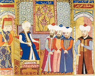
Mehmed I, also known as Mehmed Çelebi or Kirişçi, was the sultan of the Ottoman Empire from 1413 to 1421. Son of Sultan Bayezid I and his concubine Devlet Hatun, he fought with his brothers over control of the Ottoman realm in the Ottoman Interregnum (1402–1413). Starting from the province of Rûm he managed to bring first Anatolia and then the European territories (Rumelia) under his control, reuniting the Ottoman state by 1413, and ruling it until his death in 1421. Called "The Restorer," he reestablished central authority in Anatolia, and he expanded the Ottoman presence in Europe by the conquest of Wallachia in 1415. Venice destroyed his fleet off Gallipoli in 1416 as the Ottomans lost a naval war.

The Karamanids, also known as the Emirate of Karaman and Beylik of Karaman, was an Anatolian beylik of Salur tribe origin, centered in South-Central Anatolia around the present-day Karaman Province. From the mid 14th century until its fall in 1487, the Karamanid dynasty was one of the most powerful beyliks in Anatolia.

Rumkale, also known as Urumgala, is a ruined fortress on the Euphrates, located in the province of Gaziantep and 50 km west of Şanlıurfa.
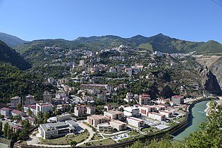
Artvin is a city in northeastern Turkey about 30 kilometres inland from the Black Sea. It is the seat of Artvin Province and Artvin District. Its population is 25,841 (2021).

Elazığ is a city in the Eastern Anatolia region of Turkey, and the administrative centre of Elazığ Province and Elazığ District. Founded in and around the former city of Harput, it is located in the uppermost Euphrates valley. The plain on which the city extends has an altitude of 1,067 metres (3,501 ft). Elazığ resembles an inland peninsula surrounded by the natural Lake Hazar and reservoirs of Keban Dam, Karakaya Dam, Kıralkızı and Özlüce. Its population is 387,072 (2022).

Kütahya is a city in western Turkey which lies on the Porsuk River, at 969 metres above sea level. It is the seat of Kütahya Province and Kütahya District. Its population is 263,863 (2022). The region of Kütahya has large areas of gentle slopes with agricultural land culminating in high mountain ridges to the north and west.

Muş is a city in eastern Turkey. It is the seat of Muş Province and Muş District. Its population is 120,699 (2022). Almost all of its population consists of Kurds.
Adilcevaz is a town in Bitlis Province of Turkey. It is on the northern shore of Lake Van. It is the seat of Adilcevaz District.
Mazgirt, is a town and seat of the Mazgirt District of the Tunceli Province in Turkey. It had a population of 1,344 in 2021 and is populated by Kurds.
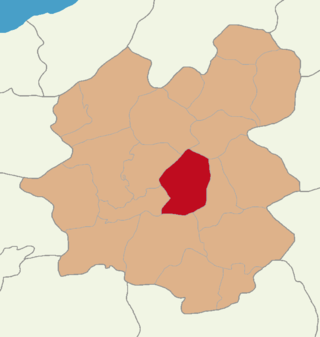
Pertek is a town and seat of Pertek District in Tunceli Province, Turkey. It had a population of 6,365 in 2021 and is populated by Kurds and Turks. The mayor is Recai Vural from the Justice and Development Party (Turkey) (AKP).

Palu is a town of Elazığ Province of Turkey. It is the seat of Palu District. The current mayor is Efrayim Ünalan (AKP). Its population is 9,602 (2021). Inhabited since ancient times, Palu was the capital of the classical Armenian region of Balabitene and then, much later, of the Kurdish Emirate of Palu. In the early 20th century, Palu was relocated from its old location to the current site.
Divriği is a town of eleven thousand people in Sivas Province, Turkey, and is the district capital of Divriği District. The town lies on a gentle slope on the south bank of the Çaltısuyu river, a tributary of the Karasu river which flows into the Euphrates.

Hoşap Castle is a large 17th century castle located in the village of Hoşab, Gürpınar District, Van, Turkey. It is at a distance of approximately 50 km to the city center of Van.
Pasinler or Basean, is a municipality and district of Erzurum Province, Turkey. Its area is 1,134 km2, and its population is 27,055 (2022). It lies on the Aras River.
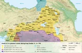
The Urartu was an Iron Age kingdom centered around the Armenian highlands between Lake Van, Lake Urmia, and Lake Sevan. The territory of the ancient kingdom of Urartu extended over the modern frontiers of Turkey, Iran, Iraq, and the Republic of Armenia. Its kings left behind cuneiform inscriptions in the Urartian language, a member of the Hurro-Urartian language family. Since its re-discovery in the 19th century, Urartu, which is commonly believed to have been at least partially Armenian-speaking, has played a significant role in Armenian nationalism.

Silifke Castle is a medieval castle in Turkey.

Tunceli Province, formerly Dersim Province, is a province in the Eastern Anatolia Region of Turkey. Its central city is Tunceli. The province is considered part of Turkish Kurdistan and has a Kurdish majority. Moreover, it is the only province in Turkey with an Alevi majority. The province has eight municipalities, 366 villages and 1,087 hamlets.
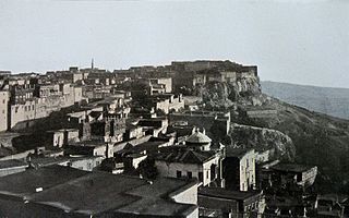
Harpoot or Kharberd is an ancient town located in the Elazığ Province of Turkey. It now forms a small district of the city of Elazığ. In the late Ottoman period, it fell under the Mamuret-ul-Aziz Vilayet. Artifacts from around 2000 BC have been found in the area. The town is famous for its Harput Castle, and incorporates a museum, old mosques, a church, and the Buzluk (Ice) Cave. Harput is about 700 miles (1,100 km) from Istanbul.
Sağman is a village in the Pertek District, Tunceli Province, Turkey. The village is populated by Turks and had a population of 156 in 2021.

Harput Castle, also known as Milk Castle, is a castle located in the historical Harput neighborhood within the borders of the current Elazığ Province, Turkey. It was built by the Urartians on a rectangular plan. The castle consists of two parts, internal and external. According to legend, a scarcity of water and abundance of milk during its construction meant that milk was added to the castle's mortar, leading to it being sometimes called "Milk Castle".


