Kastamonu Castle

Last updated
Kastamonu Castle
Kastamonu Kalesi
Kastamonu, Turkey
Kastamonu Kalesi.jpg
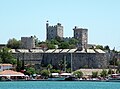
Kastamonu Castle from the city center
Turkey adm location map.svg
Red pog.svg
Kastamonu Castle
Coordinates 41°22′28″N33°46′11″E / 41.37444°N 33.76972°E / 41.37444; 33.76972
TypeCastle
Site information
Controlled by Byzantine Empire
Seljuks
Candarids
Ottoman Empire
Site history
Materialsstone

Kastamonu Castle is a medieval castle in Kastamonu, Turkey.

Contents

Geography

The castle lies inside the urban fabric of the modern city. It is situated slightly to the south west of the city center at an elevation of about 860 metres (2,820 ft).

History

During the 10th century, the area around Kastamonu was under the rule of the Byzantine commander Manuel Erotikos Komnenos who built the castle bearing his name: Kastra Komnenon, "Castle of the Komnenoi", a corrupted version of which later became the name of the city in Turkish, i.e. Kastamonu. The city and the castle were captured by the Çobanoğlu on behalf of the Seljuks of Rum. [1] After the Çobanoğlu, the castle fell to the Candaroğulları and finally to the Ottoman Empire. During the Turkish Republic era, in 1943, a part of the castle was destroyed as a result of 1943 Tosya–Ladik earthquake. [2] In 2005 Kastamonu municipality partially restored the castle. [3]

Building

The original castle had fortification walls around the city. But presently only the inner castle which was restored during the Candarid era is partially standing. [4] The north to south dimension of the castle is 155 metres (509 ft) and the width is 30 metres (98 ft) (narrowest) and 50 metres (160 ft) (widest). There are 15 bastions and a secret passage to the outer castle. [3]

Related Research Articles

<span class="mw-page-title-main">Kastamonu Province</span> Province of Turkey

Kastamonu Province is one of the provinces of Turkey, in the Black Sea region to the north of the country. It is surrounded by Sinop to the east, Bartın, Karabük to the west, Çankırı to the south, Çorum to the southeast and the Black Sea to the north.

<span class="mw-page-title-main">Aksaray Province</span> Province of Turkey in Central Anatolia

Aksaray Province is a province in central Turkey. Its adjacent provinces are Konya along the west and south, Niğde to the southeast, Nevşehir to the east, and Kırşehir to the north. It covers an area of 7,626 square kilometres (2,944 sq mi). The provincial capital is the city of Aksaray. Aksaray is one of the four provinces in the area of Cappadocia, along with Nevşehir, Niğde and Kayseri. Also the 3,000-metre (9,843 ft) volcano Mount Hasan stands between Aksaray and Niğde. Summers are hot and dry on the plain, but the area is green and covered in flowers in springtime, when water streams off the mountainside. The 2,400 m2 salt lake, Tuz Gölü, lies within the boundaries of Aksaray, a large area of swamp with a maximum depth of 1 metre.

<span class="mw-page-title-main">Hammershus</span> Ruins off Bornholm

Hammershus is a medieval era fortification at Hammeren on the northern tip of the Danish island of Bornholm. The fortress was partially demolished around 1750 and is now a ruin. It was partially restored around 1900.

<span class="mw-page-title-main">Chobanids (beylik)</span> Beylik

The Chobanids were the ruling dynasty of the Anatolian beylik that controlled the city and region of Kastamonu in the 13th century.

<span class="mw-page-title-main">Qasr al-Hayr al-Gharbi</span> Building in Homs Governorate, Syria

Qasr al-Hayr al-Gharbi is a Syrian desert castle or qasr located 80 km south-west of Palmyra on the Damascus road. The castle is a twin palace of Qasr al-Hayr al-Sharqi, built by the Umayyad caliph Hisham ibn Abd al-Malik in 727 CE. It was built in the Umayyad architectural style.

Karadere Dam is a dam in Kastamonu Province, Turkey, built between 1993 and 2007. The development was backed by the Turkish State Hydraulic Works. Karadere Dam is built for irrigation purposes and can be found between Kastamonu and Taşköprü. The scope of work includes 1,500,000 cubic metres (53,000,000 cu ft) of excavation and 3,000,000 m3 (110,000,000 cu ft) of fill. It has a 497-metre (1,631 ft) long diversion tunnel which is 3.5 metres (11 ft) in diameter.

<span class="mw-page-title-main">Cleopatra's Gate</span> Historical gate in Tarsus, Turkey

Cleopatra's Gate is a city gate of Tarsus, in Mersin Province, Turkey, named after the Egyptian (Ptolemaic) queen Cleopatra VII.

<span class="mw-page-title-main">Meydancık Castle</span> Ruins of an ancient castle in Mersin Province, Turkey

Meydancık Castle is a castle ruin in Mersin Province, Turkey. The original name was Kirshu and the name of the ruin during Ottoman times was Beydili Kale.

<span class="mw-page-title-main">Mut Castle</span>

Mut Castle is a castle in Mut, Mersin Province, Turkey.

<span class="mw-page-title-main">Ilgaz Mountains</span> Mountain range in Turkey

Ilgaz Mountains is a mountain range in northwest Anatolia, Turkey. It belongs to the Pontic Mountains system.

<span class="mw-page-title-main">Castle of Kars</span>

The Castle of Kars is a former fortification located in Kars, Turkey. It is also known under the name Iç Kale.

<span class="mw-page-title-main">Stone Bridge (Silifke)</span>

The Stone Bridge or Silifke Bridge is a historical bridge in Mersin Province, Turkey.

<span class="mw-page-title-main">Tekfur ambarı</span>

Tekfur ambarı is a large cistern in Silifke ( Seleukeia) ilçe district center of Mersin Province, Turkey. A part of the city of Silifke, it is situated to the west of city center and to the east of Silifke castle at 36°23′N33°55′E. It was built during the early years of Byzantine Empire. The building material is face stone. The west to east dimension is 46 metres (151 ft) and the north to south dimension is 23 metres (75 ft). The depth of the cistern is 14 metres (46 ft). The total water capacity is about 12 000 tonnes. At the east side of the cistern there is a spiral staircase. There are 8 niches at the 46 m dimension and 5 niches at the 23 m dimension.

<span class="mw-page-title-main">Cistern of Aspar</span>

The Cistern of Aspar or Great Cistern, known in Turkish as Sultan Selim Çukurbostanı, was a Byzantine open-air water reservoir in the city of Constantinople.

<span class="mw-page-title-main">Cistern of Mocius</span>

The Cistern of Mocius, known in Turkish as Altımermer Çukurbostanı, was the largest Byzantine open-sky water reservoir built in the city of Constantinople.

<span class="mw-page-title-main">Boyabat Castle</span> Castle in Boyabat, Sinop Province, Turkey

Boyabat Castle, is a castle in the town of Boyabat, Sinop Province, Turkey built by the Paphlagonians in antiquity and reconstructed under Roman, Byzantine, and Ottoman rule. The castle functions as a museum today.

Kastamonu Ethnography Museum is a museum in Kastamonu, Turkey

<span class="mw-page-title-main">Temple of Jupiter (Silifke)</span>

The Temple of Jupiter is a ruined Roman temple in Silifke, Turkey. It was built in the 2nd century, and presently one column still stands.

<span class="mw-page-title-main">Çobandede Bridge</span> Bridge in Erzurum Province, Turkey

Çobandede Bridge is a historical bridge in Erzurum Province of Turkey.

<span class="mw-page-title-main">Eğirdir Castle</span> Castle in Turkey

Eğirdir Castle is a castle in Turkey.

References

41°22′28″N33°46′11″E / 41.37444°N 33.76972°E / 41.37444; 33.76972