Ancaster, Lincolnshire

Last updated

Ancaster
St.Martin's church, Ancaster, Lincs. - geograph.org.uk - 81148.jpg
St Martin's Church, Ancaster
Lincolnshire UK location map.svg
Red pog.svg
Ancaster
Location within Lincolnshire
Population1,317 (2001) [1]
OS grid reference SK983438
  London 100 mi (160 km)  S
District
Shire county
Region
Country England
Sovereign state United Kingdom
Post town Grantham
Postcode district NG32
Dialling code 01400
Police Lincolnshire
Fire Lincolnshire
Ambulance East Midlands
UK Parliament
List of places
UK
England
Lincolnshire
52°58′N0°32′W / 52.97°N 00.54°W / 52.97; -00.54

Ancaster is a village and civil parish in the South Kesteven district of Lincolnshire, England, on the site of a Roman town. The population of the civil parish was 1,317 at the 2001 census, increasing to 1,647 at the 2011 census. [2] The civil parish includes the settlements of Sudbrook and West Willoughby. [3]

Contents

The village is related to the titles of Duke of Ancaster and Kesteven and Earl of Ancaster

History

Ancaster was a Roman town at the junction of the Roman roads of Ermine Street [4] [5] and King Street. [6]

During the Romano-British period, the Romans built a roadside settlement on the site of a "Corieltauvi" settlement. It was traditionally thought to have been named "Causennis," although that is now believed to be Saltersford near Grantham. Ancaster lies on Ermine Street, the major Roman road heading north from London. To the north-west of Ancaster is a Roman marching camp, and some 4th-century Roman earthworks are still visible. [7] Excavations have found a cemetery containing more than 250 Roman burials, including 11 stone sarcophagi.[ citation needed ] In the later years of Roman occupation, a large stone wall with accompanying ditches was erected around the town, possibly for defence against marauding Saxons.

The place name Ancaster is first attested in a 12th-century Danelaw charter from the reign of Henry II, and in a legal document of 1196, where it appears as Anecastre. The name means "the Roman fort of 'Anna'." [8]

An excavation by the television programme Time Team in 2002 revealed a cist burial bearing an inscription to the god Viridius. The dig also uncovered Iron Age to 3rd-century pottery, a 1st-century brooch, and some of the Roman town wall. [9]

Ancaster Hall at the University of Nottingham was named after the parish, as was the extinct title of the Earl of Ancaster.[ citation needed ]

In 2005, the once widespread but now rare tall thrift plant was discovered in Ancaster churchyard, one of only two places in the country where the plant has been found to occur. A preservation regime for the plant was instituted by English Nature. [10]

The town of Ancaster in Ontario, Canada, was established in Upper Canada in 1792 and was named after Ancaster, Lincolnshire, by British army officer and the first Lieutenant Governor of Upper Canada John Simcoe, apparently inspired to do so by Peregrine Bertie, the 3rd Duke of Ancaster and Kesteven. [11]

Geography

The River Trent formerly flowed east from the Nottingham area towards the North Sea via the Vale of Belvoir and the Ancaster gap in the limestone ridge known to the north as Lincoln Edge). [12]

Ancaster lies midway between Sleaford and Grantham on the A153 road, at its junction with the B6403 (Ermine Street). North of the village, the B6403 (High Dike) is the dividing line between South and North Kesteven. Towards Sleaford lies Wilsford and to the west Sudbrook.

The civil parish boundaries are different: the civil parish also covers the settlements of Sudbrook and West Willoughby. [13]

Amenities

Ancaster has a Church of England primary school, [14] a butcher and grocery shop, a small railway station on the Nottingham–Skegness line, and a post office and petrol station. Of two public houses in Ermine Street, [15] only the Railway Inn remains. A sports and social club is associated with the playing field, which hosts Ancaster Cricket Club. West of the village on Willoughby Moor is a holiday park. [16] There are also two nearby nature reserves, each a Site of Special Scientific Interest, where the tall thrift plant is found. [17]

Church

The village's Grade I listed Anglican parish church is dedicated to St Martin, [18] [19] one of many churches on Roman sites which are dedicated to the Roman soldier who converted to Christianity and later became Bishop of Tours and a saint. St Martin's stands slightly elevated on the Roman road Ermine Street, on the probable site of a Roman temple. It is first documented in 1200 when the body of Bishop Hugh was rested overnight at the church while on its way to Lincoln.[ citation needed ] The church has decorated Norman arches and an Early English font. The corbels are decorated with medieval figurative imagery: a drinking nun, an older woman, and a farmer with a medieval headdress. There is also a Green Man "mouth-puller" in the vestry and the remains of a Sheela na gig on the north side of the tower. There are also figures carved on the wooden ceiling. Two Roman relief sculptures were found on the East Wall of the church in the 1960s.[ citation needed ]

The ecclesiastical parish links to Wilsford as part of the Loveden Deanery of the Diocese of Lincoln. [20]

Related Research Articles

<span class="mw-page-title-main">Ermine Street</span> Roman road from London to York, England

Ermine Street is a major Roman road in England that ran from London (Londinium) to Lincoln and York (Eboracum). The Old English name was Earninga Strǣt (1012), named after a tribe called the Earningas, who inhabited a district later known as Armingford Hundred, around Arrington, Cambridgeshire, and Royston, Hertfordshire. "Armingford", and "Arrington" share the same Old English origin. The original Celtic and Roman names for the route remain unknown. It is also known as the Old North Road from London to where it joins the A1 Great North Road near Godmanchester.

<span class="mw-page-title-main">Bourne, Lincolnshire</span> Market town in Lincolnshire, England

Bourne is a market town and civil parish in the South Kesteven district of Lincolnshire, England. It lies on the eastern slopes of the limestone Kesteven Uplands and the western edge of the Fens, 11 miles (18 km) north-east of Stamford, 12 miles (19 km) west of Spalding and 17 miles (27 km) north of Peterborough. The population at the 2011 census was 14,456. A 2019 estimate put it at 16,780.

<span class="mw-page-title-main">Boothby Graffoe</span> Village and civil parish in the North Kesteven district of Lincolnshire, England

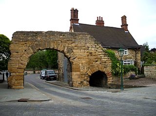
Boothby Graffoe is a village and civil parish in the North Kesteven district of Lincolnshire, England. The population of the civil parish at the 2011 census was 223. It is situated approximately 7 miles (10 km) south from the city and county town of Lincoln, and on the A607 Ermine Street Roman road.

Lincolnshire, England derived from the merging of the territory of the ancient Kingdom of Lindsey with that controlled by the Danelaw borough Stamford. For some time the entire county was called 'Lindsey', and it is recorded as such in the Domesday Book. Later, Lindsey was applied to only the northern core, around Lincoln; it was defined as one of the three 'Parts of Lincolnshire', along with Holland in the south-east and Kesteven in the south west.

<span class="mw-page-title-main">Bracebridge Heath</span> Village and civil parish in Lincolnshire, England

Bracebridge Heath is a village and civil parish in the North Kesteven district of Lincolnshire, England. It is 2 miles (3 km) south of Lincoln and straddles the border with the Lincoln and North Kesteven district boundaries.

<span class="mw-page-title-main">Wilsford, Lincolnshire</span> Village in the North Kesteven district of Lincolnshire, England

Wilsford is a village and civil parish in the North Kesteven district of Lincolnshire, England. The population of the civil parish was 400 at the 2011 census.

<span class="mw-page-title-main">Grimsthorpe</span> Hamlet in the South Kesteven district of Lincolnshire, England

Grimsthorpe is a hamlet in the South Kesteven district of Lincolnshire, England. It is situated on the A151 road, and 3 miles (5 km) north-west from Bourne. Grimsthorpe falls within the civil parish of Edenham, which is governed by Edenham Grimsthorpe Elsthorpe & Scottlethorpe Parish Council.

<span class="mw-page-title-main">Barkston</span> English village in the South Kesteven district of Lincolnshire

Barkston is an English village and civil parish in the South Kesteven district of Lincolnshire. The parish population was 497 at the 2001 census and 493 at the 2011 census. The village lies about 4 miles (6 km) north of the market town of Grantham, on the A607, just south of the junction with the A153 to Ancaster.

Ashby de la Launde and Bloxholm is a civil parish in the North Kesteven district of Lincolnshire, England. According to the 2001 Census it had a population of 796, increasing to 837 at the 2011 census. The parish includes the villages of Ashby de la Launde and Bloxholm, and the southern part of Scopwick Heath. For administrative reasons the parish council is also responsible for the adjacent parish of Temple Bruer with Temple High Grange.

<span class="mw-page-title-main">Aslackby and Laughton</span> Civil parish in the South Kesteven district of Lincolnshire, England

Aslackby and Laughton is a civil parish in the South Kesteven district of Lincolnshire, England. According to the 2001 census the parish had a population of 243, in 102 households. increasing slightly to 251 in 118 households at the 2011 census. It consists of the village of Aslackby, the hamlet of Laughton, and scattered farms, and part of the hamlet of Graby.

<span class="mw-page-title-main">Aunsby and Dembleby</span> Civil parish in the North Kesteven district of Lincolnshire, England

Aunsby and Dembleby is a civil parish in the North Kesteven district of Lincolnshire, England. According to the 2001 Census it had a population of 125. The parish includes Aunsby and Dembleby, which were separate parishes until 1931, and the hamlet of Scott Willoughby.

<span class="mw-page-title-main">Billingborough</span> Village and civil parish in the South Kesteven district of Lincolnshire, England

Billingborough is a village and civil parish in the South Kesteven district of Lincolnshire, England. It is situated approximately 10 miles (16 km) north of Bourne and 10 miles south of Sleaford, and on the B1177 between Horbling and Pointon just south of the A52.

<span class="mw-page-title-main">Welbourn</span> Village and civil parish in the North Kesteven district of Lincolnshire, England

Welbourn is a village and civil parish in the North Kesteven district of Lincolnshire, England. The population of the civil parish at the 2011 census was 647. The village is situated on the A607 road, 11 miles (18 km) south from Lincoln and 8 miles (13 km) north-west from Sleaford, and between the villages of Leadenham and Wellingore. To the east lies the course of Ermine Street, now the Viking Way.

<span class="mw-page-title-main">Leadenham</span> Village and civil parish in North Kesteven district of Lincolnshire, England

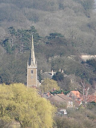
Leadenham is a village and civil parish in North Kesteven district of Lincolnshire, England. The population of the civil parish at the 2011 census was 410. It lies 11 miles (18 km) north from Grantham, 14 miles (23 km) south of Lincoln and 9 miles (14 km) north west of Sleaford on the A607 between Welbourn and Fulbeck, and at the southern edge of the Lincoln Cliff.

<span class="mw-page-title-main">Ingoldsby</span> Small village in the South Kesteven district of Lincolnshire, England

Ingoldsby is a small village in the South Kesteven district of Lincolnshire, England. It is situated 7 miles (11 km) south-east from the market town of Grantham, 32 miles (51 km) south of the county town of Lincoln, and 33 miles (53 km) east of the City of Nottingham. The village contains approximately 121 households.

<span class="mw-page-title-main">Silk Willoughby</span> Village and civil parish in the North Kesteven district of Lincolnshire, England

Silk Willoughby is a village and civil parish in the North Kesteven district of Lincolnshire, England. The population of the civil parish at the 2011 census was 299. It is situated 2 miles (3 km) south from Sleaford.

High Dyke is a minor road following a length of the Roman Road Ermine Street in the English county of Lincolnshire, between Woolsthorpe-by-Colsterworth and Ancaster, and onwards nearly to Bracebridge Heath. It is also the name of a small settlement on that road, 1 mile (1.6 km) south-east from Great Ponton, near to the mouth of Stoke Tunnel on the East Coast Main Line. High Dyke is also a name for the general area between Easton and Great Ponton. On the Ordnance Survey 1:25000 sheets it is spelled High Dike.

<span class="mw-page-title-main">Little Ponton</span> Village in South Kesteven district of Lincolnshire, England

Little Ponton is a village in the civil parish of Little Ponton and Stroxton, in the South Kesteven district of Lincolnshire, England. It lies 2 miles (3 km) south of Grantham, about 60 metres (200 ft) above sea level.

<span class="mw-page-title-main">St Martin's Church, Ancaster</span> Church in United Kingdom

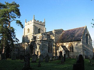
St Martin's Church is a Grade I listed Anglican church, dedicated to Martin of Tours, in Ancaster, Lincolnshire, England. The church is 6 miles (10 km) north-east from Grantham, below the southern edge of the Lincoln Cliff, and at the side of High Dyke, part of the old Ermine Street Roman road. St Martin's is in the ecclesiastical parish of Ancaster and Wilsford, in the Deanery of Loveden, and the Diocese of Lincoln.

Temple Bruer with Temple High Grange is a civil parish and a former extra-parochial area in North Kesteven, Lincolnshire, England which had in the Medieval period been held by the Knights Templar and later by the Knights Hospitaller of Temple Bruer Preceptory. By an Act of Parliament passed on 5 March 1879, Temple Bruer with Temple High Grange was constituted as a parish. At that time the parish was in Flaxwell wapentake, Sleaford Union and County Court district, and the ecclesiastical rural deanery of Longobody.

References

  1. "2001 census". Neighbourhood Statistics. Office for National Statistics. Archived from the original on 4 March 2016. Retrieved 20 April 2013.
  2. "Civil parish population 2011". Neighbourhood Statistics. Office for National Statistics. Retrieved 20 April 2016.
  3. "Civil Parish details".
  4. Margary, Ivan D (1973). Roman roads in Britain. pp. 224–30.
  5. Historic England. "Ermine Street in Lincolnshire (1031813)". Research records (formerly PastScape). Retrieved 4 July 2010.
  6. Historic England. "King Street (1035135)". Research records (formerly PastScape). Retrieved 4 July 2010.
  7. Historic England. "Roman remains (325933)". Research records (formerly PastScape). Retrieved 4 July 2010.
  8. Eilert Ekwall,The Concise Oxford Dictionary of English Place-names, p. 9.
  9. "Romano-British cemetery site, west of Ancaster", HeritageGateway, English Heritage. Retrieved 13 January 2013
  10. "Anger over wild flower graveyard", BBC News, 3 August 2005
  11. "Historical Ancaster".
  12. M. Posnansky, "The Pleistocene Succession in the Middle Trent Basin," Proc. Geologists' Assoc., 71 (1960), pp. 285–311.
  13. "Ancaster Parish Council"., Lincolnshire.gov.uk. Retrieved 28 June 2013.
  14. Ancaster CE Primary School. Retrieved 28 June 2013.
  15. Ermine Street.
  16. holiday park.
  17. Armeria maritima elongata. Retrieved 9 September 2019.
  18. Historic England. "Church of St Martin (1062422)". National Heritage List for England . Retrieved 9 July 2011.
  19. Historic England. "Church of St Martin (325927)". Research records (formerly PastScape). Retrieved 4 July 2010.
  20. "Ancaster/Wilsford Group P C C". Archived from the original on 16 July 2011. Diocese of Lincoln. Retrieved 28 June 2013