Related Research Articles

Top-of-the-World is a census-designated place (CDP) in Gila and Pinal counties in the U.S. state of Arizona. The population was 274 at the 2020 census, up from 231 at the 2010 census, and down from 330 at the 2000 census.
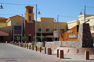
Sahuarita is a town in Pima County, Arizona, United States. Sahuarita is located south of the Tohono O'odham Nation and abuts the north end of Green Valley, 15 miles (24 km) south of Tucson. The 2022 population estimate was 35,638.

Vail is a census-designated place (CDP) in Pima County, Arizona, United States. It is 24 miles (39 km) southeast of Tucson. The population was 10,208 at the 2010 census, up from 2484 in the 2000 census. The area is known for the nearby Colossal Cave, a large cave system, and the Rincon Mountains District of Saguaro National Park, a top tourism spot within Arizona.

Dudleyville is a census-designated place (CDP) in Pinal County, Arizona, United States. The population was 959 at the 2010 census.

Oracle is a census-designated place (CDP) in Pinal County, Arizona, United States. The population was 3,686 at the 2010 Census, falling to 3,051 at the 2020 Census.

Dewey–Humboldt is a town in Yavapai County, Arizona, United States. The population of the town was 3,894 according to the 2010 census. The Dewey–Humboldt area was a census-designated place (CDP) at the 2000 census, at which time its population was 6,295.

Lake Montezuma is a census-designated place (CDP) in Yavapai County in the U.S. state of Arizona. The population was 5,111 at the 2020 census. The CDP includes the communities of Rimrock and McGuireville. Located along Interstate 17, it is 20 miles (32 km) south of Sedona and 8 miles (13 km) north of Camp Verde in central Arizona's Verde Valley.

Fairbank is a ghost town in Cochise County, Arizona, next to the San Pedro River. First settled in 1881, Fairbank was the closest rail stop to nearby Tombstone, which made it an important location in the development of southeastern Arizona. The town was named for Chicago investor Nathaniel Kellogg Fairbank who partially financed the railroad, and was the founder of the Grand Central Mining Company, which had an interest in the silver mines in Tombstone. Today Fairbank is located within the San Pedro Riparian National Conservation Area.

The Camp Grant massacre, on April 30, 1871, was an attack on Pinal and Aravaipa Apaches who surrendered to the United States Army at Camp Grant, Arizona, along the San Pedro River. The massacre led to a series of battles and campaigns fought between the Americans, the Apache, and their Yavapai allies, which continued into 1875, the most notable being General George Crook's Tonto Basin Campaign of 1872 and 1873.

Tiger is a former populated place in Pinal County in the U.S. state of Arizona. The town was settled as Schultzcirca 1881 in what was then the Arizona Territory, then later reestablished as Tiger after World War I.

Bumble Bee is a ghost town in the Bradshaw Mountains of Yavapai County, Arizona, United States, named for nearby Bumble Bee Creek. The townsite area is commonly used by RV campers in winter.
Hereford is a populated place in Cochise County along the San Pedro Riparian National Conservation Area in the southern part of the U.S. state of Arizona. It is southeast of Sierra Vista and is a part of the Sierra Vista-Douglas micropolitan area. The elevation is 4,193 feet at the location of the original townsite at the far eastern end of the unincorporated area; the residential area runs for another 8 miles west from this location, blending into the unincorporated area of Nicksville at an elevation of approximately 4800 feet. Hereford Station Post Office is located at the far western end of Nicksville, at the foot of the Huachuca Mountains.

Fort Grant is a state prison and a former United States Army fortification in the U.S. state of Arizona. Fort Grant is located on the southwestern slope of Mount Graham in what is now Graham County. The post is named for Ulysses S. Grant, the 18th President of the United States.

Harshaw is a ghost town in Santa Cruz County in the southeastern part of the U.S. state of Arizona. The town was settled in the 1870s, in what was then Arizona Territory. Founded as a mining community, Harshaw is named after the cattleman-turned-prospector David Tecumseh Harshaw, who first successfully located silver in the area. At the town's peak near the end of the 19th century, Harshaw's mines were among Arizona's highest producers of ore, with the largest mine, the Hermosa, yielding approximately $365,455 in bullion over a four-month period in 1880.

Aravaipa Creek is a drainage between three mountain ranges in southwest Graham County, Arizona – the Galiuro Mountains, the Santa Teresa Mountains and the Pinaleno Mountains. These mountains are part of the high altitude Madrean Sky Islands located in southern Arizona and New Mexico in the United States, and northern Sonora and Chihuahua states in Mexico.
Camp Grant was the name used from 1866 to 1872 for the United States military post at the confluence of the San Pedro River and Aravaipa Creek in the Arizona Territory. It is near the site of the Camp Grant massacre.

Pantano is a ghost town located in eastern Pima County, Arizona, between Benson and Vail. Access is via the Marsh Station Road interchange on I-10. It was established as a small railroad town with the arrival of the Southern Pacific in 1880, supplanting the earlier Ciénega station that was located to the west of Pantano.
Anaconda is an unincorporated community in southern Franklin County, Missouri, United States. The community is southeast of Interstate 44, between St. Clair and Stanton.
The Pennsylvania State Game Lands Number 14 are Pennsylvania State Game Lands in Cameron, and Elk Counties in Pennsylvania in the United States providing hunting, bird watching, and other activities.

Calabasas is a former populated place or ghost town, within the census-designated place of Rio Rico, a suburb of Nogales in Santa Cruz County, Arizona, United States.
References
- 1 2 U.S. Geological Survey Geographic Names Information System: Aravaipa, Arizona
- ↑ Will Croft Barnes, Arizona Place Names, University of Arizona Press, Tucson, 1988, p. 136[ ISBN missing ]
- ↑ Cram's Modern Atlas: The New Unrivaled. J. R. Gray & Company. 1902.
- ↑ Premier Atlas of the World: Containing Maps of All Countries of the World, with the Most Recent Boundary Decisions, and Maps of All the States, Territories, and Possessions of the United States with Population Figures from the Latest Official Census Reports, Also Data of Interest Concerning International and Domestic Political Questions. Rand McNally & Company. 1925. pp. 165–166.
- ↑ Aravaipa from ghosttowns.com accessed, February 21, 2014
32°57′26″N110°21′18″W / 32.95722°N 110.35500°W
Municipalities and communities of Graham County, Arizona, United States | ||
|---|---|---|
| City |  | |
| Towns | ||
| CDPs | ||
| Populated places | ||
| Indian reservations | ||
| Ghost towns | ||
| Footnotes | ‡This populated place also has portions in an adjacent county or counties | |