Atlantic City, Wyoming

Last updated

Atlantic City, Wyoming
CDP
Atlantic city 1.jpg
Atlantic City Mercantile, 2011
WYMap-doton-AtlanticCity.PNG
Location of Atlantic City, Wyoming
Usa edcp location map.svg
Red pog.svg
Atlantic City, Wyoming
Location in the United States
Coordinates: 42°29′43″N108°43′8″W / 42.49528°N 108.71889°W / 42.49528; -108.71889
Country United States
State Wyoming
County Fremont
Area
  Total7.8 sq mi (20 km2)
  Land7.8 sq mi (20 km2)
  Water0.0 sq mi (0 km2)
Elevation
7,694 ft (2,345 m)
Population
 (2010) [1]
  Total37
  Density4.7/sq mi (1.8/km2)
Time zone UTC-7 (Mountain (MST))
  Summer (DST) UTC-6 (MDT)
ZIP code
82520
Area code 307
FIPS code 56-04015 [2]
GNIS feature ID1584989 [3]

Atlantic City is a census-designated place (CDP) in Fremont County, Wyoming, United States. The population was 37 at the 2010 census. The community is a small mining settlement in a gulch near South Pass in southwestern Wyoming. It was founded as a mining camp following the 1867 gold rush in the region. The town declined following the end of the placer gold rush in the early 1870s, but continued to exist as advances in mining technology allowed further extraction of gold. From the 1960s until 1983, it was the location of US Steel iron ore mine. The town is accessible by gravel roads from nearby Wyoming Highway 28.

Contents

The town today has rustic flavor, with a small cluster of residences and the preserved Atlantic City Mercantile store and restaurant along the main road through town. It attracts a small number of tourists in the summer as well.

Geography

Atlantic City is located at 42°29′43″N108°43′8″W / 42.49528°N 108.71889°W / 42.49528; -108.71889 (42.495228, -108.718830). [4]

According to the United States Census Bureau, the CDP has a total area of 7.8 square miles (20.2 km2), all land. [5]

Climate

According to the Köppen Climate Classification system, Atlantic City has a semi-arid climate, abbreviated "BSk" on climate maps. [6]

Climate data for Atlantic City, Wyoming, 1991–2020 normals, extremes 1897–present: 7821ft (2384m)
MonthJanFebMarAprMayJunJulAugSepOctNovDecYear
Record high °F (°C)46
(8)
46
(8)
60
(16)
69
(21)
81
(27)
88
(31)
92
(33)
91
(33)
87
(31)
75
(24)
64
(18)
52
(11)
92
(33)
Mean maximum °F (°C)41.5
(5.3)
42.6
(5.9)
51.8
(11.0)
65.0
(18.3)
73.6
(23.1)
81.8
(27.7)
85.4
(29.7)
84.1
(28.9)
81.0
(27.2)
66.5
(19.2)
55.0
(12.8)
42.8
(6.0)
86.3
(30.2)
Average high °F (°C)29.5
(−1.4)
31.3
(−0.4)
38.1
(3.4)
46.2
(7.9)
56.6
(13.7)
68.8
(20.4)
77.9
(25.5)
75.7
(24.3)
66.5
(19.2)
52.0
(11.1)
37.5
(3.1)
28.7
(−1.8)
50.7
(10.4)
Daily mean °F (°C)15.4
(−9.2)
19.2
(−7.1)
25.7
(−3.5)
33.6
(0.9)
42.7
(5.9)
53.0
(11.7)
60.6
(15.9)
58.9
(14.9)
49.8
(9.9)
37.4
(3.0)
25.0
(−3.9)
16.7
(−8.5)
36.5
(2.5)
Average low °F (°C)1.2
(−17.1)
7.1
(−13.8)
13.3
(−10.4)
20.9
(−6.2)
28.8
(−1.8)
37.2
(2.9)
43.2
(6.2)
42.0
(5.6)
33.1
(0.6)
22.7
(−5.2)
12.4
(−10.9)
4.7
(−15.2)
22.2
(−5.4)
Mean minimum °F (°C)−20.6
(−29.2)
−20.4
(−29.1)
−8.1
(−22.3)
−0.1
(−17.8)
15.5
(−9.2)
24.6
(−4.1)
31.3
(−0.4)
31.4
(−0.3)
22.3
(−5.4)
1.3
(−17.1)
−9.5
(−23.1)
−20.5
(−29.2)
−25.6
(−32.0)
Record low °F (°C)−29
(−34)
−31
(−35)
−22
(−30)
−9
(−23)
10
(−12)
20
(−7)
26
(−3)
25
(−4)
8
(−13)
−20
(−29)
−26
(−32)
−36
(−38)
−36
(−38)
Average precipitation inches (mm)0.96
(24)
1.49
(38)
1.62
(41)
1.89
(48)
2.60
(66)
1.55
(39)
0.82
(21)
1.05
(27)
1.31
(33)
1.55
(39)
1.58
(40)
1.46
(37)
17.88
(453)
Average snowfall inches (cm)14.9
(38)
23.6
(60)
22.4
(57)
24.1
(61)
8.7
(22)
0.0
(0.0)
0.0
(0.0)
0.0
(0.0)
2.9
(7.4)
6.0
(15)
12.8
(33)
19.7
(50)
135.1
(343.4)
Source 1: NOAA [7]
Source 2: XMACIS2 (2013-2020 snowfall, records & monthly max/mins) [8]

Demographics

As of the census [2] of 2000, there were 39 people, 23 households, and 8 families residing in the CDP. The population density was 1.9 people per square mile (0.7/km2). There were 99 housing units at an average density of 4.7/sq mi (1.8/km2). The racial makeup of the CDP was 94.87% White and 5.13% Native American. Hispanic or Latino of any race were 2.56% of the population.

There were 23 households, out of which 13.0% had children under the age of 18 living with them, 30.4% were married couples living together, and 65.2% were non-families. 52.2% of all households were made up of individuals, and 4.3% had someone living alone who was 65 years of age or older. The average household size was 1.70 and the average family size was 2.50.

In the CDP, the population was spread out, with 12.8% under the age of 18, 7.7% from 25 to 44, 76.9% from 45 to 64, and 2.6% who were 65 years of age or older. The median age was 48 years. For every 100 females, there were 129.4 males. For every 100 females age 18 and over, there were 126.7 males.

The median income for a household in the CDP was $21,094, and the median income for a family was $48,750. Males had a median income of $21,250 versus $28,750 for females. The per capita income for the CDP was $15,756. There were no families and 21.9% of the population living below the poverty line, including no under eighteens and 100.0% of those over 64.

Education

Public education in the community of Atlantic City is provided by Fremont County School District #1.

In The Outlaw Trail: A Journey Through Time, Robert Redford states, "There is only one hub of activity in Atlantic City. It is the Mercantile, a combination bar and general store where one can get any supplies needed to survive or thrive." [9]

See also

Related Research Articles

<span class="mw-page-title-main">Hot Springs County, Wyoming</span> County in Wyoming, United States

Hot Springs County is a county in the U.S. state of Wyoming. As of the 2020 United States Census, the population was 4,696, making it the second-least populous county in Wyoming. Its county seat is Thermopolis. The county is named for the hot springs located in Hot Springs State Park.

<span class="mw-page-title-main">Goshen County, Wyoming</span> County in Wyoming, United States

Goshen County is a county in the U.S. state of Wyoming. As of the 2020 United States Census, the population was 12,498. Its county seat is Torrington. The eastern boundary of the County borders the Nebraska state line.

<span class="mw-page-title-main">Fremont County, Wyoming</span> County in Wyoming, United States

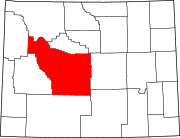
Fremont County is a county in the U.S. state of Wyoming. As of the 2020 United States census, the population was 39,234, making it the fifth-most populous county in Wyoming. Its county seat is Lander. The county was founded in 1884 and is named for John C. Frémont, a general, explorer, and politician. It is roughly the size of the state of Vermont.

<span class="mw-page-title-main">Circle, Alaska</span> CDP in Alaska, United States

Circle is a census-designated place (CDP) in Yukon-Koyukuk Census Area, Alaska, United States. At the 2010 census the population was 104, up from 100 in 2000.

<span class="mw-page-title-main">Arapahoe, Wyoming</span> Census-designated place in Wyoming, United States

Arapahoe is a census-designated place (CDP) in Fremont County, Wyoming, United States. The population was 1,656 at the 2010 census. A Catholic mission was founded here in 1884. St Stephen's Mission Church, located near Arapahoe, is part of the Catholic mission.

Boulder Flats is a census-designated place (CDP) in Fremont County, Wyoming, United States. The population was 408 at the 2010 census.

<span class="mw-page-title-main">Ethete, Wyoming</span> CDP in Wyoming, United States

Ethete is a census-designated place (CDP) in Fremont County, Wyoming, United States. The population was 1,553 at the 2010 census. The town is located on the Wind River Indian Reservation. It grew up around the Episcopal St. Michael's Mission.

<span class="mw-page-title-main">Fort Washakie, Wyoming</span> CDP in Wyoming, United States

Fort Washakie is a census-designated place (CDP) in Fremont County, Wyoming, United States, within the Wind River Indian Reservation and along U.S. Route 287. The population was 1,759 at the 2010 census. The headquarters for the Eastern Shoshone Tribe is located in Fort Washakie, as well as the Bureau of Indian Affairs agency for the Wind River Indian Reservation.

<span class="mw-page-title-main">Jeffrey City, Wyoming</span> Census-designated place in Wyoming, United States

Jeffrey City is a former uranium mining boomtown located in Fremont County, in the central part of the U.S. state of Wyoming. The town is known in Wyoming and the American West as symbol of a boomtown that went "bust" very quickly, as the mine was shut down in 1982 and over 95% of the inhabitants left the town within three years. The population was 58 at the 2010 census, far lower than its onetime population of several thousand people. For statistical purposes, the United States Census Bureau has defined Jeffrey City as a census-designated place (CDP).

Johnstown is a census-designated place (CDP) in Fremont County, Wyoming, United States. The population was 242 at the 2010 census.

<span class="mw-page-title-main">Lander, Wyoming</span> City in Wyoming, United States

Lander is a city in Wyoming, United States, and the county seat of Fremont County. It is in central Wyoming, along the Middle Fork of the Popo Agie River, just south of the Wind River Indian Reservation. It is a tourism center with several nearby guest ranches. Its population was 7,546 at the 2020 census.

<span class="mw-page-title-main">Pavillion, Wyoming</span> Town in Wyoming, United States

Pavillion is a town in Fremont County, Wyoming, United States. The population was 231 at the 2010 census.

<span class="mw-page-title-main">Riverton, Wyoming</span> City in Wyoming, United States

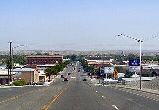
Riverton is a city in Fremont County, Wyoming, United States. The city's population was 10,682 at the 2020 census, making it the most populous city in the county.

<span class="mw-page-title-main">Smoot, Wyoming</span> Census-designated place in Wyoming, United States

Smoot is a census-designated place (CDP) in Lincoln County, Wyoming, United States. The population was 195 at the 2010 census.

<span class="mw-page-title-main">Alcova, Wyoming</span> CDP in Wyoming, United States

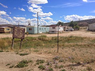
Alcova is a census-designated place (CDP) in Natrona County, Wyoming, United States. It is part of the Casper, Wyoming Metropolitan Statistical Area. The population was 34 at the 2020 census. Wyoming's center of population is located in the small Town of Alcova. Alcova and the nearby reservoir, Alcova Lake, are popular vacation spots with many seasonal residents.

<span class="mw-page-title-main">Casper Mountain, Wyoming</span> CDP in Wyoming, United States

Casper Mountain is a census-designated place (CDP) on Casper Mountain in Natrona County, Wyoming, United States. It is part of the Casper, Wyoming Metropolitan Statistical Area. The population was 401 at the 2010 census.

<span class="mw-page-title-main">Meeteetse, Wyoming</span> Town in Wyoming, United States

Meeteetse is a town in Park County, Wyoming, United States. The population was 327 at the 2010 census.

<span class="mw-page-title-main">Boulder, Wyoming</span> CDP in Wyoming, United States

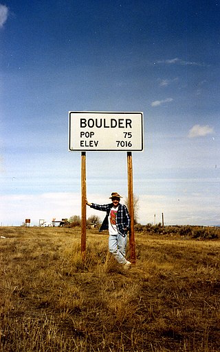
Boulder is a census-designated place (CDP) in Sublette County, Wyoming, United States. The population was 170 at the 2010 census.

<span class="mw-page-title-main">Cora, Wyoming</span> CDP in Wyoming, United States

Cora is a census-designated place (CDP) in Sublette County, Wyoming. The population was 114 at the 2020 census.

Alta is a census-designated place (CDP) in Teton County, Wyoming, United States. The population was 394 at the 2010 census. It is part of the Jackson, WY–ID Micropolitan Statistical Area, and it is located between Driggs, Idaho and the Grand Targhee ski resort.

References

  1. "2010 City Population and Housing Occupancy Status". U.S. Census Bureau. Retrieved July 13, 2012.[ dead link ]
  2. 1 2 "U.S. Census website". United States Census Bureau . Retrieved January 31, 2008.
  3. "US Board on Geographic Names". United States Geological Survey. October 25, 2007. Retrieved January 31, 2008.
  4. "US Gazetteer files: 2010, 2000, and 1990". United States Census Bureau. February 12, 2011. Retrieved April 23, 2011.
  5. "2010 Wyoming Place Names". U.S. Census Bureau. Archived from the original on July 4, 2012. Retrieved July 13, 2012.
  6. Climate Summary for Atlantic City, Wyoming
  7. "U.S. Climate Normals Quick Access – Station: Atlantic City, WY". National Oceanic and Atmospheric Administration. Retrieved June 13, 2023.
  8. "xmACIS". National Oceanic and Atmospheric Administration. Retrieved December 3, 2023.
  9. Redford, Robert (1976). The Outlaw Trail: A Journey Through Time. New York: Grosset & Dunlap. pp. 50–55. ISBN   0448145901.