Jeffrey City, Wyoming

Last updated
Jeffrey City, Wyoming
WYMap-doton-JeffreyCity.PNG
Location of Jeffrey City, Wyoming
Usa edcp location map.svg
Red pog.svg
Jeffrey City, Wyoming
Location in the United States
Coordinates: 42°29′26″N107°49′42″W / 42.49056°N 107.82833°W / 42.49056; -107.82833 Coordinates: 42°29′26″N107°49′42″W / 42.49056°N 107.82833°W / 42.49056; -107.82833
CountryUnited States
State Wyoming
County Fremont
Area
  Total28.5 sq mi (73.8 km2)
  Land28.3 sq mi (73.4 km2)
  Water0.2 sq mi (0.4 km2)
Elevation
6,335 ft (1,931 m)
Population
 (2010) [1]
  Total58
  Density2.0/sq mi (0.79/km2)
Time zone UTC−7 (Mountain (MST))
  Summer (DST) UTC−6 (MDT)
ZIP code
82310
Area code(s) 307
FIPS code 56-40555 [2]
GNIS feature ID1590071 [3]
Boarded-up abandoned housing in Jeffrey City, Wyoming, former uranium boomtown Boarded-up abandoned housing in Jeffrey City, Wyoming.jpg
Boarded-up abandoned housing in Jeffrey City, Wyoming, former uranium boomtown

Jeffrey City is a former uranium mining boomtown located in Fremont County, in the central part of the U.S. state of Wyoming. The town is known in Wyoming and the American West as symbol of a boomtown that went "bust" very quickly, as the mine was shut down in 1982 and over 95% of the inhabitants left the town within three years. [4] The population was 58 at the 2010 census, [1] far lower than its onetime population of several thousand people. For statistical purposes, the United States Census Bureau has defined Jeffrey City as a census-designated place (CDP).

Contents

History

Jeffrey City began in 1931 as "Home on the Range", the 640-acre (2.6 km2) homestead of a Nebraska couple named the Petersons, who relocated because Mr. Peterson was sick after having been gassed in World War I. Mrs. Beulah Peterson (later Walker) opened two gasoline pumps when the highway came through, and began cooking for those who stopped. The post office at Split Rock, 14 miles (23 km) away, closed in 1943, and Mrs. Peterson took up the task of handling the ranchers' mail. She canceled the letters with "Home on the Range". She retired her post office cancellation stamp in 1957 when Home on the Range became Jeffrey City. Her family members are currently restoring the old Home on the Range post office site.[ citation needed ]

Home on the Range became Jeffrey City when those who came to mine uranium sought to honor Dr. C. W. Jeffrey, a wealthy doctor from Rawlins, Wyoming, who initially financed the costs for prospector and businessman Bob Adams to start the Western Nuclear Corporation mining firm and open a uranium mine near the area in 1957, during the Cold War and the height of uranium demand. [4]

Thousands of people looking for high-paying mining jobs streamed into Jeffrey City, and Western Nuclear designed and financed a company town for the workers and their families. At the height of the boom town optimism, a separate high school building was added and an Olympic-sized swimming pool and third gymnasium was built. In the late 1970s and early 1980s, the uranium market collapsed and the mine was forced to close. As was typical of many boom towns, Jeffrey City was singularly dependent on the local mine, and after it closed there was no reason for residents to remain. What was once a thriving local community with shops, schools, library, sheriff, youth hostel, churches, medical clinics and more, became a ghost town as 95% of the residents left the town by 1986. [4] Today, few institutions remain: the First (Southern) Baptist Church (which is still doing well thanks to the area ranchers who attend), [5] a restaurant and bar called the Split Rock Café that caters to the few local residents and those passing through on the highway, and Monk King Bird Pottery, a pottery studio. [6] The Green Mountain Motel provides perhaps the only lodging along the 122-mile (196 km) route between Rawlins and Riverton. [7]

Geography and climate

Jeffrey City is located in southeastern Fremont County along U.S. Route 287, 67 miles (108 km) northwest of Rawlins and Interstate 80, and 58 miles (93 km) southeast of Lander, the Fremont County seat. According to the United States Census Bureau, the Jeffrey City CDP has a total area of 28.5 square miles (73.8 km2), of which 28.3 square miles (73.4 km2) is land and 0.2 square miles (0.4 km2), or 0.56%, is water. [1] The community is in the valley of the Sweetwater River, an east-flowing tributary of the North Platte River.

Climate data for Jeffrey City, Wyoming (1981–2010)
MonthJanFebMarAprMayJunJulAugSepOctNovDecYear
Average high °F (°C)31.8
(−0.1)
34.4
(1.3)
44.5
(6.9)
54.6
(12.6)
64.8
(18.2)
75.5
(24.2)
84.9
(29.4)
83.3
(28.5)
72.4
(22.4)
58.5
(14.7)
42.1
(5.6)
31.2
(−0.4)
56.5
(13.6)
Average low °F (°C)8.5
(−13.1)
10.2
(−12.1)
19.1
(−7.2)
26.0
(−3.3)
34.5
(1.4)
42.9
(6.1)
49.5
(9.7)
48.0
(8.9)
38.2
(3.4)
28.0
(−2.2)
17.5
(−8.1)
8.6
(−13.0)
27.6
(−2.4)
Average precipitation inches (mm)0.3
(7.6)
0.43
(11)
0.84
(21)
1.25
(32)
1.88
(48)
1.17
(30)
0.91
(23)
0.59
(15)
0.84
(21)
0.93
(24)
0.59
(15)
0.42
(11)
10.19
(259)
Average snowfall inches (cm)4.3
(11)
6.8
(17)
8.9
(23)
10.1
(26)
4.5
(11)
0.4
(1.0)
0.0
(0.0)
0.0
(0.0)
1.3
(3.3)
6.6
(17)
7.8
(20)
5.8
(15)
56.5
(144)
Source: NOAA [8]

Demographics

As of the census [2] of 2000, there were 106 people, 45 households, and 32 families residing in the CDP. The population density was 3.7 inhabitants per square mile (1.4/km2). There were 112 housing units at an average density of 3.9 per square mile (1.5/km2). The racial makeup of the CDP was 98.11% White or 104 people, 0.94% or one Indigenous American, and 0.94% or one person from two or more races. Hispanic or Latino of any race were 1.89% of the population, or two people.

There were 45 households, out of which 15.6% had children under the age of 18 living with them, 66.7% were married couples living together, 2.2% or one household had a female householder with no husband present, and 26.7% were non-families. 17.8% of all households were made up of individuals, and 4.4% had someone living alone who was 65 years of age or older. The average household size was 2.36 and the average family size was 2.61.

In the CDP, the population was spread out, with 14.2% under the age of 18, 8.5% from 18 to 24, 26.4% from 25 to 44, 41.5% from 45 to 64, and 9.4% who were 65 years of age or older. The median age was 46 years. For every 100 females, there were 152.4 males. For every 100 females age 18 and over, there were 127.5 males.

The median income for a household in the CDP was $42,857, and the median income for a family was $42,679. Males had a median income of $65,156 versus $23,750 for females. The per capita income for the CDP was $20,061. There were no families and 8.2% of the population living below the poverty line, including no under eighteens and none of those over 64.

Education

Public education in the community of Jeffrey City is provided by Fremont County School District #1. In 2013 the school served kindergarten through 4th grade, and had two students. Prior to 1997 Jeffrey City had its own school district. [9]

See also

Related Research Articles

Sublette County, Wyoming County in Wyoming, United States

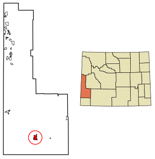
Sublette County is a county in the U.S. state of Wyoming. As of the 2020 United States Census, the population was 8,728. The county seat is Pinedale. It is a sparsely populated rural county in western Wyoming, along the Green River.

Fremont County, Wyoming County in Wyoming, United States

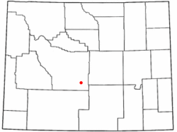
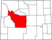
Fremont County is a county in the U.S. state of Wyoming. As of the 2020 United States Census, the population was 39,234, making it the fifth-most populous county in Wyoming. Its county seat is Lander. The county was founded in 1884 and is named for John C. Frémont, a general, explorer, and politician. It is roughly the size of the state of Vermont.

Carbon County, Wyoming County in Wyoming, United States

Carbon County is a county in the U.S. state of Wyoming. As of the 2020 United States Census, the population was 14,537. Its county seat is Rawlins. Its south border abuts the north line of Colorado.

Morenci, Arizona CDP in Greenlee County Arizona

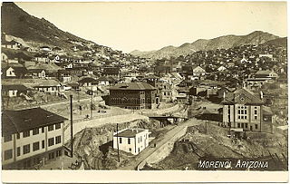
Morenci is a census-designated place (CDP) and company town in Greenlee County, Arizona, United States, and was founded by the Detroit Copper Mining Company of Arizona. The population was 2000 at the 2000 census and 1,489 at the 2010 census. The biggest employer in Morenci and the owner of the town is Freeport-McMoRan, the owner of the Morenci Mine, the largest copper mining operation in North America, and one of the largest copper mines in the world. The town was a site of the Arizona Copper Mine Strike of 1983. The large open-pit mine is north of the town.

Randsburg, California California Historical Landmark

Randsburg is a census-designated place (CDP) in Kern County, California, United States. Randsburg is located 17 miles (27 km) south of Ridgecrest, at an elevation of 3,504 feet (1,068 m). The population was 69 in the 2010 census, down from 77 in the 2000 census.

Mariposa, California Census-designated place in California, United States

Mariposa is a census-designated place (CDP) in and the county seat of Mariposa County, California, United States. The population was 2,173 at the 2010 census, up from 1,373 at the 2000 census. The city is named after the flocks of monarchs seen overwintering there by early explorers.

Goodsprings, Nevada Unincorporated community in Nevada, United States

Goodsprings is an unincorporated community in Clark County, Nevada, United States. The population was 229 at the 2010 census.

Church Rock, New Mexico Human settlement in New Mexico, United States

Church Rock is a census-designated place (CDP) in McKinley County, New Mexico, United States. The population was 1,128 at the 2010 census. Church Rock is named for Church Rock, a prominent natural landmark with the same name.

Los Cerrillos, New Mexico CDP in New Mexico, United States

Los Cerrillos is a census-designated place (CDP) in Santa Fe County, New Mexico, United States. It is part of the Santa Fe, New Mexico Metropolitan Statistical Area. The population was 229 at the 2000 census. Accessible from State Highway 14 or The Turquoise Trail, Cerrillos is on the road from Santa Fe to Albuquerque, closer to Santa Fe. There are several shops and galleries, a post office, and the Cerrillos Hills State Park, which has five miles of hiking trails. The Cerrillos Turquoise Mining Museum contains hundreds of artifacts from the American Old West and the Cerrillos Mining District. It also displays cardboard cutouts of characters from the film Young Guns and information on other movies which have been filmed in and around Cerrillos. This is a good place to view Cerrillos Turquoise from the Browns' turquoise claim, The Little Chalchihuitl.

Centennial, Wyoming CDP in Wyoming, United States

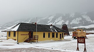
Centennial is a small town in Albany County, Wyoming, United States. The population was 270 at the 2010 census.

Wright, Wyoming Town in Wyoming, United States

Wright is a town in Campbell County, Wyoming, United States. The population was 1,807 at the 2010 census.

Rawlins, Wyoming City in Wyoming, United States

Rawlins is a city in Carbon County, Wyoming, United States. The population was 9,259 at the 2010 census. It is the county seat of Carbon County. It was named for Union General John Aaron Rawlins, who camped in the locality in 1867.

Arapahoe, Wyoming Census-designated place in Wyoming, United States

Arapahoe is a census-designated place (CDP) in Fremont County, Wyoming, United States. The population was 1,656 at the 2010 census. A Catholic mission was founded here in 1884. St Stephen's Mission Church, located near Arapahoe, is part of the Catholic mission.

Atlantic City, Wyoming CDP in Wyoming, United States

Atlantic City is a census-designated place (CDP) in Fremont County, Wyoming, United States. The population was 37 at the 2010 census. The community is a small mining settlement in a gulch near South Pass in southwestern Wyoming. It was founded as a mining camp following the 1867 gold rush in the region. The town declined following the end of the placer gold rush in the early 1870s, but continued to exist as advances in mining technology allowed further extraction of gold. From the 1960s until 1983, it was the location of US Steel iron ore mine. The town is accessible by gravel roads from nearby Wyoming Highway 28.

Ethete, Wyoming CDP in Wyoming, United States

Ethete is a census-designated place (CDP) in Fremont County, Wyoming, United States. The population was 1,553 at the 2010 census. The town is located on the Wind River Indian Reservation. It grew up around the Episcopal St. Michael's Mission.

Fort Washakie, Wyoming CDP in Wyoming, United States

Fort Washakie is a census-designated place (CDP) in Fremont County, Wyoming, United States, within the Wind River Indian Reservation and along U.S. Route 287. The population was 1,759 at the 2010 census. The headquarters for the Eastern Shoshone Tribe is located in Fort Washakie, as well as the Bureau of Indian Affairs agency for the Wind River Indian Reservation.

Johnstown is a census-designated place (CDP) in Fremont County, Wyoming, United States. The population was 242 at the 2010 census.

Kemmerer, Wyoming City in Wyoming, United States

Kemmerer is the largest city in and the county seat of Lincoln County, Wyoming, United States, with a population was 2,656 at the 2010 census.

Miners Delight, Wyoming United States historic place

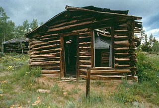
Hamilton City, or Miner's Delight as it was commonly known, was a town in Fremont County, Wyoming, United States, on the southeastern tip of the Wind River Range, that prospered during the mining boom in the American West in the second half of the 19th century. It was a "sister city" of Atlantic City and South Pass City. Today a few buildings still stand as a reminder of an era in Wyoming's past history.

Yellowcake boomtown Uranium mining town with rapid increase in population and economic growth followed by decrease

A Yellowcake boomtown is a town or community that rapidly increases in population and economics due to the discovery of uranium ore-bearing minerals, and the development of uranium mining, milling or enrichment activities. After these activities cease, the town "goes bust" and the population decreases rapidly.

References

  1. 1 2 3 "Geographic Identifiers: 2010 Demographic Profile Data (G001): Jeffrey City CDP, Wyoming". U.S. Census Bureau, American Factfinder. Retrieved October 26, 2016.[ dead link ]
  2. 1 2 "U.S. Census website". United States Census Bureau . Retrieved 2008-01-31.
  3. "US Board on Geographic Names". United States Geological Survey. 2007-10-25. Retrieved 2008-01-31.
  4. 1 2 3 Home on the Range No More: The Boom and Bust of a Wyoming Uranium Mining Town 1957 -1958.
  5. "First Baptist Church of Jeffrey City, WY" . Retrieved 2012-04-14.
  6. Byron Seeley. "Monkingbird Pottery" . Retrieved 2012-04-14.
  7. "JC MOTEL - Reviews (Jeffrey City, WY)" . Retrieved 17 May 2015.
  8. "NOWData - NOAA Online Weather Data". National Oceanic and Atmospheric Administration . Retrieved May 5, 2013.
  9. Todd, Leah (1 September 2013). "TWO KIDS FOR THE COUNT First day of school at Jeffrey City Elementary". Billings Gazette. Retrieved 10 August 2018.