Troutville is a town in Botetourt County, Virginia, United States. The population was 458 at the 2020 census. The town is located along the U.S. Route 11 between Cloverdale and Buchanan. It is part of the Roanoke Metropolitan Statistical Area.

Halifax is a town in Halifax County, Virginia, United States, along the Banister River. The population was 1,309 at the 2010 census. It is the county seat of Halifax County.

Cedar Bluff is a town in Tazewell County, Virginia, United States. The population was 1,139 at the 2010 census. It is part of the Bluefield, WV-VA micropolitan area, which has a population of 107,578.
Coeburn is a town in Wise County, Virginia, United States, along the Guest River. The population was 2,139 at the 2010 census.

Mason, also known as Mason City, is a town in Mason County, West Virginia, United States. The population was 865 at the 2020 census. It is part of the Point Pleasant, WV–OH Micropolitan Statistical Area.

Harman is a town in Randolph County, West Virginia, United States. The population was 96 at the 2020 census.

Huttonsville is a town in Randolph County, West Virginia, United States, along the Tygart Valley River. The population was 163 at the 2020 census.

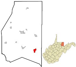
Harrisville is a town in Ritchie County, West Virginia, United States. It is the county seat of Ritchie County. Harrisville is located at the junction of State Routes 31 and 16, five miles south of U.S. 50. Within the community are an elementary school, the county board of education, many businesses, three banks, a library, offices of the Ritchie Gazette and The Pennsboro News, a municipal park, and North Bend Golf Course. North Bend Lake and North Bend State Park are located just outside town limits. Municipal elections are held every two years.
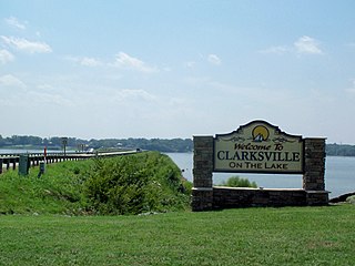
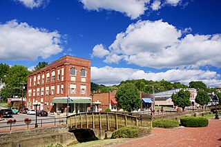
Clarksville is a town in Mecklenburg county in the U.S. state of Virginia, near the southern border of the commonwealth. The population was 1,139 at the 2010 census. Since the town has numerous buildings of the 18th-, 19th-, and early 20th-century architecture, the downtown area of Clarksville has been designated a Historic District on the National Register of Historic Places and Virginia's Historic Register. Clarksville claims the title of Virginia's only Lakeside town. Nearby the town of Clarksville is Occoneechee State Park.
Huntersville is a census-designated place (CDP) located in Pocahontas County, West Virginia, United States in the Alleghany Mountains. As of the 2010 census, its population was 73. It is located six miles east of Marlinton and four miles west of Minnehaha Springs. Huntersville received its name because it was a rendezvous for trappers and hunters who came to trade pelts for supplies. It served as the county seat of Pocahontas County until 1891 when the county's residents voted to move the seat to Marlinton. A local newspaper called "The Pocahontas Times" is distributed in the area.

Cass is a census-designated place (CDP) and unincorporated communityon the Greenbrier River in Pocahontas County, West Virginia, United States. The population was 38 at the 2020 census. The community, founded in 1901, was named for Joseph Kerr Cass, vice president and cofounder of the West Virginia Pulp and Paper Company.
Brandywine is a census-designated place (CDP) located on U.S. Highway 33 in Pendleton County, West Virginia, United States. The town lies along the South Fork South Branch Potomac River at its confluence with Hawes Run. At the 2019 census, its population was 147.
Pageton is a census-designated place (CDP) in McDowell County, West Virginia, United States. As of the 2010 census, its population was 187. Pageton is located on the Tug Fork Branch of the Norfolk and Western Railway, along the Pocahontas seam of rich bituminous coal. Pageton is located on State Route 161 between Thorpe and Anawalt.
King George is a census-designated place (CDP) in and the county seat of King George County, Virginia, United States. It is sometimes referred to as King George Courthouse, because it is the location of the King George County Courthouse. The population as of the 2020 census was 4,970. The Journal Press was a local weekly newspaper published in King George and serving local areas until its final issue was published on Jan 11th, 2017.

King William is a census-designated place (CDP) in and the county seat of King William County, Virginia, United States. The population as of the 2010 census was 252. Located in King William is the oldest courthouse in continuous use in the United States, built in 1725. The community is also known as King William Courthouse or, by an alternative spelling, King William Court House.

Churchville is a census-designated place (CDP) in the western part of Augusta County, Virginia, United States. The population as of the 2010 Census was 194. Churchville is part of the Staunton–Waynesboro Micropolitan Statistical Area.
Maybeury is a census-designated place (CDP) in McDowell County, West Virginia, United States, located on U.S. Route 52 between Northfork and Bramwell. As of the 2010 census, its population was 234.
Bartow is a census-designated place (CDP) in Pocahontas County, West Virginia, United States. The population was 111 at the 2010 census.
Dailey is a census-designated place (CDP) in Randolph County, West Virginia, United States. Dailey is located on U.S. routes 219 and 250, 3 miles (4.8 km) south-southwest of Beverly. Dailey has a post office with ZIP code 26259. As of the 2010 census, its population was 114.
Vivian is a census-designated place (CDP) in McDowell County, West Virginia, United States. Vivian is located along U.S. Route 52, 1 mile (1.6 km) southeast of Kimball. As of the 2010 census, its population was 82.