
Springfield is a census-designated place (CDP) in Fairfax County, Virginia, United States. The Springfield CDP is recognized by the U.S. Census Bureau with a population of 30,484 as of the 2010 census. Homes and businesses in bordering CDPs including North Springfield, West Springfield, and Newington are usually given a Springfield mailing address. The population of the collective areas with Springfield addresses is estimated to exceed 100,000. The CDP is a part of Northern Virginia, the most populous region of the Washington Metropolitan Area.

Kingwood is a city in and the county seat of Preston County, West Virginia, United States. The population was 2,980 at the 2020 census. The city sits within the Allegheny Mountains above the Cheat River valley. It is part of the Morgantown metropolitan area.
Hooks Mills is an unincorporated community in Hampshire County, West Virginia, United States. It is located on Hooks Mill Road which intersects Cacapon River Road 4.5 miles south of Capon Bridge. Hooks Mills is named for the saw and grist mill on the Cacapon River run by the Hook family from 1848 to the late 1930s.
Clifton Mills is an unincorporated community in Preston County, West Virginia, United States. A post office was opened in Clifton Mills in 1881 and operated until being discontinued on November 22, 1963.

Cass is a census-designated place (CDP) and unincorporated community on the Greenbrier River in Pocahontas County, West Virginia, United States. The population was 38 at the 2020 census. The community, founded in 1901, was named for Joseph Kerr Cass, vice president and cofounder of the West Virginia Pulp and Paper Company.
Frametown is an unincorporated community in Braxton County, West Virginia, United States. While the heart of Frametown itself is rather small, there is a large sprawling area that considers itself to be part of the Frametown community. This is due to the large range of the United States Postal Service ZIP Code 26623 which covers the immediate area.
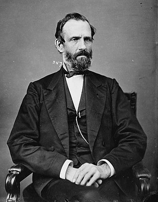
James Clark McGrew was an American politician, merchant, banker and hospital director from Virginia and West Virginia.
Elton is an unincorporated community in Summers County, West Virginia, United States. It lies to the northeast of the city of Hinton, the county seat of Summers County. Its elevation is 1,749 feet. Elton had a post office, with the ZIP code of 25965, until it closed on July 11, 2009.
Pentress is a census-designated place (CDP) in northern Monongalia County, West Virginia, United States. It lies along West Virginia Route 7 northwest of the city of Morgantown, the county seat of Monongalia County. Its elevation is 951 feet (290 m). "Pentress" is not the only name the community has had; at various times in its history, it has been known as Minors Mills, New Brownsville, Pentrees, Pentress Junction, Statler Town, Statlers Town, Statlersville, and Stradlerstown. The present name of Pentress was selected by an early settler who reportedly wanted a Welsh name. It has a post office with the ZIP Code of 26544. As of the 2010 census, its population was 175.
Gap Mills is an unincorporated community in Monroe County, West Virginia, United States. Established in 1775 and located on West Virginia Route 3 east of Union, Gap Mills has a post office with ZIP code 24941.
Secondcreek is an unincorporated community in Monroe County, West Virginia, United States. Secondcreek is northeast of Union. The ZIP code for Secondcreek is 24974; however the post office was closed in 2010.
Charmco is an unincorporated community and coal town in Greenbrier County, West Virginia, United States. Charmco is located at the junction of U.S. Route 60 and West Virginia Route 20, northeast of Rainelle. Charmco has a post office with ZIP code 25958. The community was named for the Charleston Milling Company.
Nallen is an unincorporated community in Fayette and Nicholas counties, West Virginia, United States. Nallen is located along West Virginia Route 41, 12 miles (19 km) south of Summersville. Nallen has a post office with ZIP code 26680.
Seth is an unincorporated community and coal town in Boone County, West Virginia, United States. Seth is located on West Virginia Route 3, 11 miles (18 km) east-northeast of Madison. Seth has a post office with ZIP code 25181.
Mill Point is an unincorporated community in Pocahontas County, West Virginia, United States. Mill Point is at the junction of U.S. Route 219 and state routes 39 and 55, 2.5 miles (4.0 km) northeast of Hillsboro.
Pecks Mill is an unincorporated community in Logan County, West Virginia, United States. Pecks Mill is located on the Guyandotte River and West Virginia Route 10, 1.5 miles (2.4 km) north of Mitchell Heights. Pecks Mill has a post office with ZIP code 25547.
Statts Mills is an unincorporated community in Jackson County, West Virginia, United States. Statts Mills is located on the Tug Fork and County Route 36, 7.5 miles (12.1 km) southeast of Ripley. Statts Mills had a post office, which closed on July 30, 2005.
William B. Zinn was a nineteenth-century farmer, mill-owner, militia leader and politician, who ultimately freed his slaves and became one of the founders of the State of West Virginia.

Union District, formerly Union Magisterial District, is one of five historic magisterial districts in Jackson County, West Virginia, United States. The district was originally known as Hushan's Mills Township, one of five civil townships established in 1863, at the height of the Civil War; it was subsequently given the patriotic name of Union Township. In 1872, West Virginia's townships were converted into magisterial districts. When Jackson County was redistricted in the 1990s, the area of Union District was included in the new Western Magisterial District. However, the county's historic magisterial districts continue to exist in the form of tax districts, serving all of their former administrative functions except for the election of county officials.


