The Great Barrier Reef is the world's largest coral reef system, composed of over 2,900 individual reefs and 900 islands stretching for over 2,300 kilometres (1,400 mi) over an area of approximately 344,400 square kilometres (133,000 sq mi). The reef is located in the Coral Sea, off the coast of Queensland, Australia, separated from the coast by a channel 160 kilometres (100 mi) wide in places and over 61 metres (200 ft) deep. The Great Barrier Reef can be seen from outer space and is the world's biggest single structure made by living organisms. This reef structure is composed of and built by billions of tiny organisms, known as coral polyps. It supports a wide diversity of life and was selected as a World Heritage Site in 1981. CNN labelled it one of the Seven Natural Wonders of the World in 1997. Australian World Heritage places included it in its list in 2007. The Queensland National Trust named it a state icon of Queensland in 2006.

San Pedro is a town on the southern part of the island of Ambergris Caye in the Belize District of the nation of Belize, in Central America. According to the 2015 mid-year estimates, the town has a population of about 16,444. It is the second-largest town in the Belize District and largest in the Belize Rural South constituency. The once sleepy fishing village was granted the status of a town in 1984.

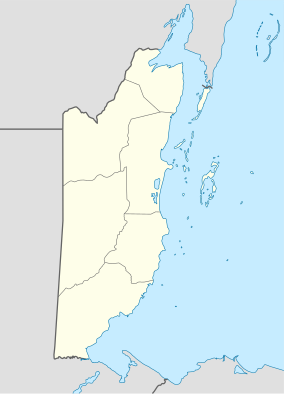
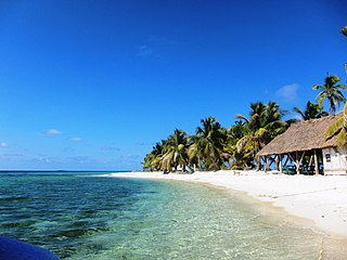
Ambergris Caye, is the largest island of Belize, located northeast of the country's mainland, in the Caribbean Sea. It is about 40 kilometres (25 mi) long from north to south, and about 1.6 kilometres (1 mi) wide. Many parts of the island have been modified by human development since the arrival of coconut plantations in the 17th century, but it remains largely white coral sand with mangrove forest at its center. Its eastern coast runs parallel to the northernmost stretch of the Belize Barrier Reef, a UNESCO World Heritage Site.

The Papahānaumokuākea Marine National Monument (PMNM) is a World Heritage listed U.S. National Monument encompassing 583,000 square miles (1,510,000 km2) of ocean waters, including ten islands and atolls of the Northwestern Hawaiian Islands. It was created in June 2006 with 140,000 square miles (360,000 km2) and expanded in August 2016 by moving its border to the limit of the exclusive economic zone, making it one of the world's largest protected areas. It is internationally known for its cultural and natural values as follows:
The area has deep cosmological and traditional significance for living Native Hawaiian culture, as an ancestral environment, as an embodiment of the Hawaiian concept of kinship between people and the natural world, and as the place where it is believed that life originates and to where the spirits return after death. On two of the islands, Nihoa and Mokumanamana, there are archaeological remains relating to pre-European settlement and use. Much of the monument is made up of pelagic and deepwater habitats, with notable features such as seamounts and submerged banks, extensive coral reefs and lagoons.
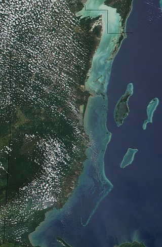
The Belize Barrier Reef is a series of coral reefs straddling the coast of Belize, roughly 300 metres (980 ft) offshore in the north and 40 kilometres (25 mi) in the south within the country limits. The Belize Barrier Reef is a 300-kilometre (190 mi) long section of the 900-kilometre (560 mi) Mesoamerican Barrier Reef System, which is continuous from Cancún on the north-eastern tip of the Yucatán Peninsula through the Riviera Maya and down to Honduras, making it the second largest coral reef system in the world after the Great Barrier Reef in Australia. It is Belize's top tourist destination, popular for scuba diving and snorkeling and attracting almost half of its 260,000 visitors. It is also vital to the country's fishing industry.

Hol Chan Marine Reserve is a marine reserve close to Ambergris Caye and Caye Caulker, off the coast of Belize. It covers approximately 18 km² (4,448 acres) of coral reefs, seagrass beds, and mangrove forest. Hol Chan is Mayan for "little channel".
Since declaring independence in 1981, Belize has enacted many environmental protection laws aimed at the preservation of the country's natural and cultural heritage, as well as its wealth of natural resources. These acts have established a number of different types of protected areas, with each category having its own set of regulations dictating public access, resource extraction, land use and ownership.
Caye Chapel is a small, private island in Belize, 16 miles (26 km) north-northeast of Belize City and 3 miles (4.8 km) south of Caye Caulker. It was once owned by Isaiah Emmanuel Morter, Belize's first African millionaire.

Tourism in Belize has grown considerably recently, and it is now the second largest industry in the nation. Belizean Prime Minister Dean Barrow has stated his intention to use tourism to combat poverty throughout the country. The growth in tourism has positively affected the agricultural, commercial, and finance industries, as well as the construction industry. The results for Belize's tourism-driven economy have been significant, with the nation welcoming almost one million tourists in a calendar year for the first time in its history in 2012.
Laughing Bird Caye is an island off the coast of Placencia, Belize. On 21 December 1991, Laughing Bird Caye National Park was declared. It is spread over an area of 1.8 acres (0.73 ha). The island is named after a population of laughing gulls which previously bred there.
Janet Patricia Gibson is a biologist and zoologist from Belize. She was awarded the Goldman Environmental Prize in 1990 for her efforts on conservation of the marine ecosystems along the Belizean coast, in particular the barrier reef system. The Belize Barrier Reef was granted UNESCO World Heritage status in 1996, through efforts of Gibson and others. She is the current director of the Belize Wildlife Conservation Society.
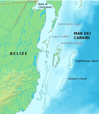
Glover's Reef is a partially submerged atoll located off the southern coast of Belize, approximately 45 kilometres from the mainland. It forms part of the outermost boundary of the Belize Barrier Reef, and is one of its three atolls, besides Turneffe Atoll and Lighthouse Reef.
Mexico Rocks is a shallow patch reef complex located off the far northern tip of Ambergris Caye, and is part of the Belize Barrier Reef system in the Caribbean Sea. The site consists of approximately 100 Holocene patch reefs clustered on a Pleistocene ridge of limestone and is composed predominantly of boulder star corals. The reef has accumulated in shallow water, about 2.5 to 5 metres deep, over the last 420 years, under static sea level conditions. The site was recommended for designation as a marine preserve in 1978, and was approved in 2015 as a part of the Hol Chan Marine Reserve. The reef is popular among snorkelers and SCUBA divers, and it is seen as an important addition to Ambergris Caye's ecotourism attractions.
Blue Ventures is a registered charity focused on nurturing locally led marine conservation. The organisation partners with coastal communities that depend on marine resources.

Half Moon Caye is an island and natural monument of Belize located at the southeast corner of Lighthouse Reef Atoll. This natural monument was the first nature reserve to have been established in Belize under the National Park Systems Act in 1981 and first marine protected area in Central America. This is also Belize's oldest site of wildlife protection since it was first designated as a bird sanctuary in 1924 to protect the habitat of the red-footed booby birds.

Turneffe Atoll is located southeast of Ambergris Caye and Caye Caulker, off the coast of Belize in Central America, 20 miles from Belize City. It is one of three atolls of the Belize Barrier Reef, along with Glover's Reef and Lighthouse Reef. It is approximately 30 miles long and 10 miles wide, making it the largest coral atoll in Belize and in the Mesoamerican Barrier Reef System. The atoll was officially declared a marine reserve on November 22, 2012.
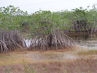
The Belizean Coast mangroves ecoregion covers the brackish and salt-water habitats along the Caribbean Sea coast of Belize, and of Amatique Bay in Guatemala; small parts in the border with Mexico are also present on this ecoregion. The mangroves are partially protected from the open sea by the Belize Barrier Reef, and this ecoregion is distinct from the reef-based Belizean Reef mangroves ecoregion offshore. There is a large population of the vulnerable West Indian manatee in the area. It covers an area of around 2850 km2.

Lighthouse Reef is an atoll in the Caribbean Sea, the easternmost part of the Belize Barrier Reef and one of its three atolls, the other two being Turneffe Atoll and Glover's Reef. Lighthouse Reef is located about 80 kilometres (50 mi) southeast of Belize City. The atoll is of oblong shape, approximately 35 kilometres (22 mi) long from north to south, and about 8 kilometres (5.0 mi) wide. It forms a shallow sandy lagoon with an area of 120 square kilometres (46 sq mi) and a depth between 2 and 6 metres deep.

The Belizean reef mangroves ecoregion covers the mangrove habitats along the islands and cayes of the Belize Barrier Reef. This ecoregion is distinct from the mainland Belizean Coast mangroves ecoregion, and may be considered a sub-unit of the overall Mesoamerican Gulf-Caribbean mangroves ecoregion.