
Nottingham is a city and unitary authority area in Nottinghamshire, East Midlands, England. It is located 110 miles (180 km) north-west of London, 33 miles (53 km) south-east of Sheffield and 45 miles (72 km) north-east of Birmingham. Nottingham is the legendary home of Robin Hood and to the lace-making, bicycle and tobacco industries. The city is also the county town of Nottinghamshire and the settlement was granted its city charter in 1897, as part of Queen Victoria's Diamond Jubilee celebrations.

Carlton is a town in the Borough of Gedling, Nottinghamshire, England. It is to the east of Nottingham. The population at the 2011 Census was 6,881. It was an urban district until 1974, whose wards had an estimated population of 48,416 in 2015. Owing to the growth of residential, commercial and industrial in the wider Gedling Borough, City of Nottingham, Borough of Broxtowe, Rushcliffe and Ashfield District, as well as the Amber Valley and Borough of Erewash in Derbyshire which have become quite urban around Nottingham, Carlton and Gedling, as well as Netherfield form a contiguous urban area.

Holme Pierrepont is a hamlet and civil parish located 5 miles (8 km) south-east of the city of Nottingham in Nottinghamshire, England. It is in the Gamston ward of the Rushcliffe local authority in the East Midlands region. The population of the civil parish as at the 2011 census was 528, and this reported 568 residents at the 2021 census.

Sneinton is a suburb of Nottingham and former civil parish in the Nottingham district, in the ceremonial county of Nottinghamshire, England. The area is bounded by Nottingham city centre to the west, Bakersfield to the north, Colwick to the east, and the River Trent to the south. Sneinton lies within the unitary authority of Nottingham City, having been part of the borough of Nottingham since 1877.

Colwick is a village and civil parish, in the Borough of Gedling of Nottinghamshire, England. It is situated to the east of Nottingham's city boundary, and forms the Colwick ward. At the time of the 2011 census, the village had a population of 2,829, falling to 2,778 at the 2021 census.
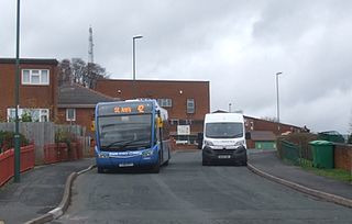
St Ann's is a large district of the city of Nottingham, in the English ceremonial county of Nottinghamshire. The population of the district at the time of the United Kingdom census, 2011 was 19,316.

Gedling is a village and former civil parish which gives its name to the larger Borough of Gedling in Nottinghamshire, England. It lies 4 miles (6.4 km) north-east of Nottingham city centre. The parish was abolished in 1935 and absorbed into the urban district of Carlton, which in turn was abolished in 1974 on the creation of borough of Gedling. The population of the Gedling ward at the 2011 census was 6,817 and 111,787 for the district. Gedling was recorded in the Domesday Book and is still a distinct settlement, although residential, commercial and industrial growth in the wider borough of Gedling and the neighbouring city of Nottingham, boroughs of Broxtowe and Rushcliffe and district of Ashfield means it can be difficult to distinguish the village of Gedling from the nearby town of Carlton, with which it has become contiguous.

Netherfield is a town in the Borough of Gedling in Nottinghamshire, England. It is situated to the east of Nottingham's city boundary and is approximately 3 miles (4.8 km) between Colwick and Carlton in the NG4 postcode area, and near the River Trent. The appropriate Gedling ward was called 'Netherfield and Colwick' until boundary reorganisation in 2015, when it became 'Netherfield', with 'Colwick' becoming a separate ward.. At the time of the 2011 census, the population of this ward was 7,398.
Carlton Town Football Club is a semi-professional football club based in Gedling, Nottinghamshire, England. Founded in 1904 as Sneinton Football Club, its early years were marked by considerable local success, leading to the club being described by the Manchester Courier in 1909 as "the leading amateur football club in Nottingham". Its reputation declined for several decades afterwards, with the team participating in obscure county divisions until the 1995–96 season saw the club join the nationwide league system. Carlton currently competes in the Northern Premier League Division One East at the eighth tier of the English football pyramid.

Nottingham Corporation Tramways was formed when Nottingham Corporation took over the Nottingham and District Tramways Company Limited, which had operated a horse and steam tram service from 1877.
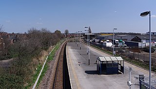
Netherfield railway station serves the town of Netherfield in the Borough of Gedling in Nottinghamshire, England. It comprises a single island platform with two tracks, with only a single waiting shelter. Access is via a flight of steps down from Chaworth Road, which crosses the line at a bridge at this point.
The Derbyshire and Staffordshire extension of the Great Northern Railway was an English railway network built by the GNR to get access to coal resources in the area to the north and west of Nottingham. The Midland Railway had obstructed the GNR in its attempts to secure a share of the lucrative business of transporting coal from the area, and in frustration the GNR built the line. The line was forked: it reached Pinxton in 1875 and a junction with the North Staffordshire Railway at Egginton, approaching Burton on Trent in 1878. The line cut through Derby, resulting in considerable demolition of housing there.

Many of the tunnels of Nottingham were built by three railway companies in and around Nottingham, England because their lines crossed substantial hills. The companies were the Great Northern Railway (GNR), the Great Central Railway (GCR), and the Nottingham Suburban Railway.

Nottingham Academy is an academy school located in Nottingham, England. It is an all-through 3-19 school. The school is made up from two predecessor schools, Greenwood Dale 11-19, The Jesse Boot Primary School 3–11, and formerly Elliott Durham 11–16.

The A612 road is an A-class road in the United Kingdom running between Nottingham and Averham, on the A617 near Newark.
The Ambergate, Nottingham and Boston and Eastern Junction Railway was a British railway company, which hoped to connect Lancashire with the port of Boston, in Lincolnshire, England. It was authorised in 1846 but was unable to raise much money. It opened a standard gauge line from a junction near Nottingham to Grantham in 1853. At Nottingham it was to rely on the Midland Railway, but that company was hostile and obstructive.

Dales United Reformed Church was built as Parkdale Congregational Church on Parkdale Road in Bakersfield Nottingham in 1930.
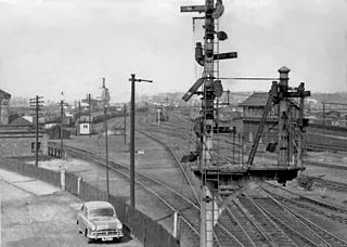
Colwick marshalling yard, also known as Colwick sidings, was a large railway marshalling yard in Netherfield, Nottingham designed for the concentration of coal traffic from the Nottinghamshire and Derbyshire Coalfield for transfer to other marshalling yards in London. It was built by the Great Northern Railway in the triangle formed by the Nottingham-Grantham line, and the Nottingham-Derby line, close to what would become Netherfield and Colwick station. It was built in stages from 1872 and was closed by British Railways in April 1970. The site has now been developed as the Victoria Retail Park.
