Kendall County is a county located on the Edwards Plateau in the U.S. state of Texas. In 2020 census, its population was 44,279. Its county seat is Boerne. The county is named for George Wilkins Kendall, a journalist and Mexican–American War correspondent.
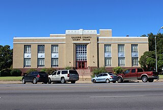
Gillespie County is a county located on the Edwards Plateau in the U.S. state of Texas. As of the 2020 census, its population was 26,725. The county seat is Fredericksburg. It is located in the heart of the rural Texas Hill Country in Central Texas. Gillespie is named for Robert Addison Gillespie, a soldier in the Mexican–American War.

Fredericksburg is a city in, and the seat of, Gillespie County, Texas, United States. As of the 2010 Census, this city had a population of 10,530.

Dallas Union Station, officially Eddie Bernice Johnson Union Station, also known as Dallas Union Terminal, is a large intermodal railroad station in Dallas, Texas. It is the third busiest Amtrak station in Texas, behind Fort Worth Central Station and San Antonio station. It serves DART Light Rail Blue and Red lines, Trinity Railway Express commuter rail and Amtrak intercity rail. It is located on Houston Street, between Wood and Young Streets, in the Reunion district of Downtown Dallas. The structure is a Dallas Landmark and is listed on the National Register of Historic Places.

U.S. Route 290 is an east–west U.S. Highway located entirely within the state of Texas. Its western terminus is at Interstate 10 southeast of Segovia, and its eastern terminus is at Interstate 610 in northwest Houston. It is the main highway between Houston and Austin and is a cutoff for travelers wanting to bypass San Antonio on Interstate 10. Throughout its length west of Austin, US 290 cuts across mountainous hills comprising the Texas Hill Country and the Edwards Plateau; between Austin and Houston, the highway then travels through gradually hilly grasslands and pine forests comprising the Gulf Coastal Plains.

Glenrio, formerly Rock Island, is an unincorporated community in both Deaf Smith County, Texas, and Quay County, New Mexico, United States. Located on the former U.S. Route 66, the ghost town sits on the Texas–New Mexico state line. It includes the Glenrio Historic District, which was listed on the National Register of Historic Places in 2007.
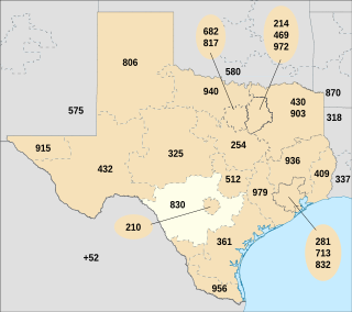
Area code 830 is the telephone area code in the North American Numbering Plan (NANP) for the Texas Hill Country and most of San Antonio's suburbs. It completely surrounds area codes 210 and 726, which serve most of San Antonio itself along with its innermost suburbs.

The Texas Department of Transportation (TxDOT) is a governmental agency and its purpose is to "provide safe, effective, and efficient movement of people and goods" throughout the state. Though the public face of the agency is generally associated with maintenance of the state's immense highway system, the agency is also responsible for aviation in the state and overseeing public transportation systems.
Doss is an unincorporated farming and ranching community at the crossroads juncture of FMs 648 and 783 in northwestern Gillespie County, Texas, United States. It is 19 miles northwest of Fredericksburg and 14 miles northeast of Harper. The zip code is 78618. The mean elevation is 1729 feet.

The following special routes exist or existed parallel to U.S. Route 87 (US 87) in Texas, primarily along former alignments. They are varyingly designated by the Texas Department of Transportation (TxDOT) as business routes of US 87, state highway loops and spurs, and business loops of Interstate 27 (I-27).
Dionicio Rodríguez (1891–1955) was a Mexican-born artist and architect whose work can be seen in Alabama, Arkansas, Illinois, Maryland, Michigan, New Mexico, Tennessee, and Texas, as well as Washington, D.C., and Mexico City.

Leon Springs is an unincorporated community in Bexar County, Texas, United States, now partially within the city limits of San Antonio. According to the Handbook of Texas, the community had a population of 137 in 2000. It is located within the San Antonio Metropolitan Area.
Grapetown is an unincorporated farming and ranching community 9.5 miles (15.3 km) south of Fredericksburg, situated on South Grape Creek in Gillespie County, in the U.S. state of Texas. It is located on the old Pinta Trail. Grapetown is noted for being the site of the first annual Gillespie County Bundes Schützenfest. The school was designated a Recorded Texas Historic Landmark in 1984, Marker number 10048.

Welfare is an unincorporated community 4 miles (6 km) southeast of Waring on the Waring-Welfare Road in west-central Kendall County, in the U.S. state of Texas. The school was designated a Recorded Texas Historic Landmark in 2000.
Cain City is a ghost town founded in 1915, 4 miles (6.4 km) southeast of Fredericksburg in Gillespie County, in the U.S. state of Texas. It was established to be a station stop of the Fredericksburg and Northern Railway Company, of which the city's namesake Charlie Cain was a leading fundraiser. The town suffered an economic downturn within a decade of being founded.

Alfred Giles was a British architect who emigrated to the United States in 1873 at the age of 20. Many of the private homes and public buildings designed by Giles are on the National Register of Historic Places and have been designated Recorded Texas Historic Landmarks. Based in San Antonio, his buildings can be found predominantly in south Texas and northern Mexico. Giles is credited with "a profound influence on architecture in San Antonio."

The Pinta Trail is a historic trail in Central Texas that was first traveled by indigenous tribes, and later explorers, settlers, soldiers, and travelers. The 19th-century Germans who settled the Texas Hill Country used part of the Pinta Trail on their journey northward from New Braunfels to found Fredericksburg. A historic battle between a Texas Rangers patrol and a band of Comanches is often said to have occurred near a ford where the Pinta Trail crossed the Guadalupe River.

The Fredericksburg and Northern Railway was a connector line between Fredericksburg, Texas, and the San Antonio and Aransas Pass Railway. It operated under that name from 1917 until 1942. From 1913 to 1917, it was operated as the San Antonio, Fredericksburg and Northern Railway.

Bikinis Sports Bar & Grill was a chain of sports bars and restaurants located in Texas. The restaurant chain was known for its scantily-clad waitresses, called "Bikini Babes", whose uniforms consist of its eponymous bikini tops, cowboy boots, and tight denim shorts. The chain was also known for trademarking the term "breastaurant" and purchasing a ghost town that was temporarily renamed "Bikinis, Texas". The chain ceased operations on December 23, 2018.

Old Tunnel State Park is a railroad tunnel of the Fredericksburg and Northern Railway, which ceased operations in 1942. The property came under the care of Texas Parks and Wildlife Department, and was officially made a state park in 2012. It is located halfway between Fredericksburg and Comfort on Old San Antonio Road. Since the shut down of the railway, the tunnel has become a bat cave, hosting over 3 million Mexican free-tailed bats and 3000 Cave myotis bats. The bats emerge at sunset during the months of May through October, and viewing is open to the public.