Texas Hill Country

Last updated

Texas Hill Country
HCSNApano2wiki.jpg
656px-Texas Hill Country Map.png
Map of Texas Hill Country
Coordinates: 30°10′27″N99°03′55″W / 30.17417°N 99.06528°W / 30.17417; -99.06528
Location Central Texas, United States
Elevation980–2,460 ft (300–750 m)

The Texas Hill Country is a geographic region of Central and South Texas, forming the southeast part of the Edwards Plateau. Given its location, climate, terrain, and vegetation, the Hill Country can be considered the border between the American Southeast and Southwest. [1] The region represents the very remote rural countryside of Central Texas, but also is home to growing suburban neighborhoods and affluent retirement communities. [2]

Contents

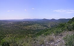
The region is notable for its karst topography and tall rugged hills of limestone or granite. [1] Many of the hills rise to a height of 400–500 ft (120–150 m) above the surrounding plains and valleys, with Packsaddle Mountain rising to a height of 800 ft (240 m) above the Llano River in Kingsland. [3] The Hill Country also includes the Llano Uplift and the second-largest granite dome in the United States, Enchanted Rock. The terrain throughout the region is characterized by a thin layer of topsoil and many exposed rocks and boulders, making the region very dry and prone to flash flooding. Native vegetation in the region includes various yucca, prickly pear cactus, desert spoon, and wildflowers in the Llano Uplift. The predominant trees in the region are Ashe juniper and Texas live oak. [4]

Bound on the east by the Balcones Escarpment, the Hill Country reaches into the far northern portions of San Antonio and western portions of Travis County including the cities of Austin and Lago Vista. As a result of springs discharging water stored in the Edwards Aquifer, several cities such as Austin, San Marcos, and New Braunfels were settled at the base of the Balcones Escarpment. As of 2016, the region's economy was one of the fastest growing in the United States. [5] [6]

Counties

According to the Texas Parks and Wildlife Department, these 25 counties are included in the Hill Country Wildlife District: [7]

History and politics

During the American Civil War, due to its large, pro-Union, German immigrant population, the Texas Hill Country was opposed to Texas seceding from the Union. [8] Subsequently, in the three quarters of a century following Reconstruction, the core of the Hill Country generally provided the solitary support base for the Republican Party in what became a one-party Democratic state.

Even when no Republicans were in the Texas Legislature during the 1930s and 1940s, Gillespie and Kendall Counties backed every Republican presidential nominee barring Herbert Hoover’s failed 1932 re-election campaign, and Republicans continued to control local government. Guadalupe and Comal Counties were less Republican, but still did not vote for Democratic nominees outside the 1912, 1932, 1936, and 1964 landslides. The region was also the only one in antebellum slave states to back the insurgent candidacy of Robert La Follette in 1924; in fact, Comal was La Follette’s top county in the nation with 73.96% of the vote, and Gillespie and Comal were the only counties south of the Mason–Dixon line to give a plurality to his “Progressive” ticket.

Geography

Because of its karst topography, the area also features a number of caverns, such as Inner Space Caverns, Natural Bridge Caverns, Bracken Cave, Longhorn Cavern State Park, Cascade Caverns, Caverns of Sonora and Cave Without a Name. The deeper caverns of the area form several aquifers, which serve as a source of drinking water for its residents. Wonder Cave in San Marcos was formed by an earthquake along the Balcones Fault. From east to west, Texas Hill Country is where the Southern United States ends and the Southwestern United States begins. [1]

Several tributaries of the Colorado River in Texas—including the Llano and Pedernales Rivers, which cross the region west to east and join the Colorado as it cuts across the region to the southeast—drain a large portion of the Hill Country. The Guadalupe, San Antonio, Frio, Medina, and Nueces Rivers originate in the Hill Country.

This region is a dividing line for certain species occurrence. For example, the California fan palm ( Washingtonia filifera ) is the only species of palm tree that is native to the continental United States west of the Hill Country's Balcones Fault. [9]

The area experiences a fusion of English, Spanish, and German influences in food, beer, architecture, and music that form a distinctively "Texan" culture separate from the state's Southern and Southwestern influences. [1] For example, the accordion was popularized in Tejano music in the 19th century due to cultural exposure to German settlers.

Devil's Backbone is an elevated, winding stretch of Ranch to Market Road 12 between San Marcos and Wimberley, then Ranch to Market Road 32 continuing through to Blanco. It has long been the subject of ghost stories. [10] Folklore about it appeared in a 1996 episode of NBC's Robert Stack anthology series Unsolved Mysteries , featuring apparitional Spanish monks, Comanche, and Lipan Apache tribes, Confederate soldiers on their horses, and a spirit of a wolf. It later re-aired when this series was hosted by Dennis Farina.

The region has emerged as the center of the Texas wine industry.[ citation needed ] Three American Viticultural Areas are located in the areas: Texas Hill Country AVA, Fredericksburg in the Texas Hill Country AVA, and Bell Mountain AVA.

Notable people

Notable people of the Texas Hill Country
NameBirthDeathNotes
Lance Armstrong 1971Professional cyclist renowned for seven consecutive Tour de France wins after surviving cancer. He was stripped of his seven Tour de France titles over a doping controversy. He was born in Plano, but is a long-time resident of Austin.
Buffalo Hump c 18001870War chief of the Penateka band of the Comanche
Liz Carpenter 19202010A journalist, author, political speech writer, humorist, public speaker, and the first female vice president of University of Texas student body, she is one of the founders of National Women's Political Caucus and co-chair of ERAmerica, traveling the country to push for passage of the Equal Rights Amendment. She drafted President Johnson's November 22, 1963, speech to the American public after the assassination of John F. Kennedy.
Jody Conradt 1941A retired women's basketball head coach, she was inducted into the Basketball Hall of Fame in 1998, Women's Basketball Hall of Fame in 1999, and the Texas Women's Hall of Fame 1986. She was born in Goldthwaite and resides in Austin. She is the first women's basketball collegiate coach to reach 700 career victories, yet she achieved a 99% graduation rate for the students on her teams.
Michael Dell 1965Founder of Dell computers, he started company in Austin and still resides there.
Shelley Duvall 1949_Actress, including The Shining , Popeye . Fort Worth-born, retired to Blanco, in Hill Country, from her long time base in California. [11]
John Henry Faulk 19131990Austin-based radio personality, author, playwright, folklorist, actor, lecturer, blacklisted during the 1950s
Kinky Friedman 1944American singer, songwriter, novelist, humorist, politician and columnist. Born in Chicago but grew up in Austin. Resides at Echo Hill Ranch near Kerrville. Founded Utopia Animal Rescue Ranch, also located near Kerrville.
Fred Gipson 19081973Novelist who authored Old Yeller , Savage Sam , and Hound Dog Man, lived in Mason
Trey Hardee 1984World Champion Decathlete and graduate of the University of Texas at Austin
Harvey Hilderbran 1960 State Representative from the western Hill Country since 1989, a Republican from Kerrville
Max Hirsch 18801969 National Museum of Racing and Hall of Fame thoroughbred horse trainer
Betty Holekamp 18261902German Texas pioneer, also called the "Betsy Ross of Texas"
Carl Hoppe 18971981San Antonio artist who painted scenes of the Texas Hill Country
Molly Ivins 19442007Political author, journalist, humorist from Austin
Lady Bird Johnson 19122007Former First Lady of the United States, Graduate of University of Texas in Austin. Business woman and one-time owner of KTBC radio and television stations turned $17,500 investment into more than $150 million. She bankrolled her husband's initial political career. Buried in Stonewall next to husband Lyndon B. Johnson. Lady Bird Johnson Wildflower Center is named for her decades-long project to beautify America's landscapes
Lyndon B. Johnson 19081973Former President of the United States, born and raised in Stonewall.
Tommy Lee Jones 1946Actor, born in San Saba.
Robert Earl Keen 1956Country singer-songwriter, former resident of Bandera, Texas and current resident of Kerrville, Texas
Ben Kweller 1981Recording artist, singer-songwriter, and actor. Originally from Greenville; now resides in Dripping Springs.
Janis Joplin 19431970Singer and songwriter, born in Port Arthur
Herman Lehmann 18591932Apache captive and then Comanche adoptee (adopted son of Chief Quanah Parker), native of Loyal Valley, 1927 autobiography, Nine Years Among the Indians
Hermann Lungkwitz 18131891Romantic landscape artist and photographer, noted for first pictorial records of the Texas Hill Country
Gerald Lyda 19232005General contractor and cattle rancher, born and raised in the Hill Country community of Marble Falls
Johnny Manziel 1992The first freshman to win Heisman trophy and quarterback for the Texas A&M University Aggies, from Kerrville
Samuel Maverick 18031870Texas lawyer, politician, land baron and signer of the Texas Declaration of Independence. His name is the source of the term "maverick," first cited in 1867, which means "independently minded."
Matthew McConaughey 1969Model/Actor, raised in Uvalde; attended The University of Texas at Austin
John O. Meusebach 18121897Founder of Fredericksburg negotiated 1847 Meusebach-Comanche Treaty (unbroken to this date) with Comanche chiefs Buffalo Hump, Santa Anna, Old Owl. Oversaw development of New Braunfels. Elected Texas State Senator for Bexar, Comal and Medina Counties. Buried Marschall-Meusebach Cemetery in Loyal Valley
Willie Nelson 1933American country singer-songwriter, author, poet, actor and activist. Austin resident
Elisabet Ney 18331907Sculptor, art pioneer, works can be found in the Smithsonian American Art Museum, Texas State Capitol, U.S. Capitol
Chester W. Nimitz 18851966Commander of U.S. Naval forces in the Pacific during World War II was from Fredericksburg and Kerrville
Old Owl c 17951849Civil Chief of the Penateka band of the Comanche Indians
Alfred P.C. Petsch 18871981Lawyer, legislator, civic leader, and philanthropist. Served in the Texas House of Representatives 1925–1941. Veteran of both World War I and World War II. [12]
Ann Richards 19332006Governor of Texas (1991–1995). Resided in Austin.
Andy Roddick 1982Former professional tennis player who resides in Austin.
Santa Anna c 17951849War Chief of the Penateka band of the Comanche Indians
Juan Nepomuceno Seguín 18061890Served on both sides during the Texas Revolution. Fought with Sam Houston and organized a Tejano rear guard. 1834 Territorial Governor of Texas, 1841 Mayor of San Antonio. Suspicions of his loyalty caused him to flee to Mexico in 1842. Served with Mexico's General Adrian Woll and participated in Woll's 1842 invasion of Texas. Seguin, Texas, is named in his honor. [13] [14] [15]
Sixpence None the Richer 1992An alternative rock band prominent in the late 1990s with their song "Kiss Me"
Frank Van der Stucken 18581929Music composer, conductor [16]
Stevie Ray Vaughan 19541990Blues guitar player resided in Austin.

See also

Related Research Articles

<span class="mw-page-title-main">Williamson County, Texas</span> County in Texas, United States

Williamson County is a county in the U.S. state of Texas. As of the 2020 census, its population was 609,017. Its county seat is Georgetown. The county is named for Robert McAlpin Williamson, a community leader and a veteran of the Battle of San Jacinto.

<span class="mw-page-title-main">Kendall County, Texas</span> County in Texas, United States

Kendall County is a county located on the Edwards Plateau in the U.S. state of Texas. In 2020 census, its population was 44,279. Its county seat is Boerne. The county is named for George Wilkins Kendall, a journalist and Mexican–American War correspondent.

<span class="mw-page-title-main">Gillespie County, Texas</span> County in Texas, U.S.

Gillespie County is a county located on the Edwards Plateau in the U.S. state of Texas. As of the 2020 census, its population was 26,725. The county seat is Fredericksburg. It is located in the heart of the rural Texas Hill Country in Central Texas. Gillespie is named for Robert Addison Gillespie, a soldier in the Mexican–American War.

<span class="mw-page-title-main">Comal County, Texas</span> County in Texas, United States

Comal County is a county located on the Edwards Plateau in the U.S. state of Texas. As of the 2020 census, its population was 161,501. Comal County is known for its rich German-Texan and European history. Its county seat is New Braunfels.

<span class="mw-page-title-main">Fredericksburg, Texas</span> City in Texas, United States

Fredericksburg is a city in and the seat of Gillespie County, Texas, United States. As of the 2010 Census, this city had a population of 10,530.

<span class="mw-page-title-main">Balcones Fault</span> Fault zone in Texas, United States

The Balcones Fault or Balcones Fault Zone is an area of largely normal faulting in the U.S. state of Texas that runs roughly from the southwest part of the state near Del Rio to the north-central region near Dallas along Interstate 35. The Balcones Fault zone is made up of many smaller features, including normal faults, grabens, and horsts. One of the obvious features is the Mount Bonnell Fault.

<span class="mw-page-title-main">Edwards Plateau</span> Geographic and ecological region of Texas, United States

The Edwards Plateau is a geographic region forming the crossroads of Central, South and West Texas, United States. It is named in honor of Haden Edwards. It is bounded by the Balcones Fault to the south and east; the Llano Uplift and the Llano Estacado to the north; and the Pecos River and Chihuahuan Desert to the west. San Angelo, Austin, San Antonio and Del Rio roughly outline the area. The plateau, especially its southeast portion, is also known as the Texas Hill Country.

<span class="mw-page-title-main">Enchanted Rock</span> Rock formation and protected area in central Texas

Enchanted Rock is a pink granite mountain located in the Llano Uplift about 17 miles (27 km) north of Fredericksburg, Texas and 24 miles (39 km) south of Llano, Texas, United States. Enchanted Rock State Natural Area, which includes Enchanted Rock and surrounding land, spans the border between Gillespie and Llano counties, south of the Llano River. Enchanted Rock covers roughly 640 acres (260 ha) and rises around 425 feet (130 m) above the surrounding terrain to an elevation of 1,825 feet (556 m) above sea level. It is the largest pink granite monadnock in the United States. Enchanted Rock State Natural Area, a part of the Texas state park system, includes 1,644 acres (665 ha). In 1936, the area was designated a Recorded Texas Historic Landmark. In 1971, Enchanted Rock was designated as a National Natural Landmark by the National Park Service.

<span class="mw-page-title-main">Medina Valley</span>

Medina Valley, also known as the Medina River Valley, is an area in south central Texas containing the Medina River, Lake Medina, and the Medina Dam. It serves to drain the Balcones Escarpment of the Texas Hill Country and irrigate the crop fields contained therein. It is approximately 120 miles long and is named for the Medina River.

<span class="mw-page-title-main">Medina River</span> River in Texas, United States

The Medina River is located in south central Texas, United States, in the Medina Valley. It was also known as the Rio Mariano, Rio San Jose, or Rio de Bagres. Its source is in springs in the Edwards Plateau in northwest Bandera County, Texas and merges with the San Antonio River in southern Bexar County, Texas, for a course of 120 miles. It contains the Medina Dam in NE Medina County, Texas which restrains Lake Medina. Much of its course is owned and operated by the Bexar-Medina-Atascosa Water District to provide irrigation services to farmers and ranchers.

<i>Washingtonia filifera</i> Species of palm tree

Washingtonia filifera, the desert fan palm, California fan palm, or California palm, is a flowering plant in the palm family Arecaceae, native to the far southwestern United States and Baja California, Mexico. Growing to 15–20 m (49–66 ft) tall by 3–6 m (10–20 ft) broad, it is an evergreen monocot with a tree-like growth habit. It has a sturdy, columnar trunk and waxy, fan-shaped (palmate) leaves.

<span class="mw-page-title-main">Comal Springs (Texas)</span>

Comal Springs are the largest concentration of naturally occurring freshwater springs in Texas. They are located in the city of New Braunfels and are the result of water percolating through the Edwards Aquifer formation.

<span class="mw-page-title-main">Texas Coastal Bend</span> Geographical region in Texas, USA

The Texas Coastal Bend, or just the Coastal Bend, is a geographical region in the US state of Texas. The name refers to the area being a curve along the Texas Gulf Coast of the Gulf of Mexico. The largest city of the Coastal Bend is Corpus Christi. It includes the Nueces Estuary and the Mission–Aransas Estuary, as well as part of Laguna Madre. The coastline is paralleled by several of the Texas barrier islands, including North Padre Island, Mustang Island, and San José Island.

<span class="mw-page-title-main">Cibolo Creek</span> Stream in South Central Texas

Cibolo Creek is a stream in South Central Texas that runs approximately 96 miles (154 km) from its source at Turkey Knob near Boerne, Texas, to its confluence with the San Antonio River in Karnes County. The creek is a tributary of the San Antonio River, at the easternmost part of its watershed.

<span class="mw-page-title-main">Geography of Texas</span> Geographical features of Texas

The geography of Texas is diverse and large. Occupying about 7% of the total water and land area of the U.S., it is the second largest state after Alaska, and is the southernmost part of the Great Plains, which end in the south against the folded Sierra Madre Oriental of Mexico. Texas is in the South Central United States of America, and is considered to form part of the U.S. South and also part of the U.S. Southwest.

<span class="mw-page-title-main">San Marcos Springs</span>

San Marcos Springs is the second largest natural cluster of springs in Texas. The springs are located in the city of San Marcos, Texas, about 30 miles (48 km) southwest of Austin and 46 miles (74 km) northeast of San Antonio.

<span class="mw-page-title-main">Salado Springs</span>

Salado Springs is the name of five groups of springs at the town of Salado in Bell County, Texas, in the United States. The springs are located 48 miles (77 km) north of Austin or 135 miles (217 km) south of Dallas.

<span class="mw-page-title-main">San Pedro Springs</span>

San Pedro Springs is the name of a cluster of springs in Bexar County, Texas, United States. These springs provide water for San Pedro Creek, which flows into the San Antonio River. The San Antonio Springs also feed into the San Antonio River.

<span class="mw-page-title-main">Greater Austin</span> Metropolitan Statistical Area in Texas, United States

The Austin–Round Rock–San Marcos metropolitan statistical area, or Greater Austin, is a five-county metropolitan area in the U.S. state of Texas, as defined by the Office of Management and Budget. The metropolitan area is situated in Central Texas on the western edge of the American South and on the eastern edge of the American Southwest, and borders Greater San Antonio to the south.

<span class="mw-page-title-main">Central Texas</span> Geographic region

Central Texas is a region in the U.S. state of Texas roughly bordered on the West by San Saba to the Southeast by Bryan and the South by San Marcos to the North by Hillsboro. Central Texas overlaps with and includes part of the Texas Hill Country and corresponds to a physiographic section designation within the Edwards Plateau, in a geographic context.

References

  1. 1 2 3 4 Jordan, Terry G. "Hill Country". Handbook of Texas Online. Retrieved November 7, 2009.
  2. Dizik, Alina (June 8, 2018). "In Texas Hill Country, a Land Rush for the Rich" . Retrieved October 22, 2020.
  3. Google Earth Terrain Data
  4. Lehman, Roy L.; Ruth O'Brien; Tammy White (2005). Plants of the Texas Coastal Bend. Texas A&M University Press. ISBN   978-1-58544-408-3.
  5. "America's Next Great Metropolis Is Taking Shape In Texas". Forbes. October 13, 2016. Retrieved October 17, 2016.
  6. "The City of the Eternal Boom". TexasMonthly.com. February 24, 2016. Retrieved January 25, 2017.
  7. Texas Parks and Wildlife. "Hill Country Wildlife Management". Land & Water: Habitats. Retrieved April 5, 2010.
  8. ‘6 Unionist Strongholds in the South during the Civil War’
  9. Hogan, C. Michael (January 5, 2009). Nicklas Stromberg (ed.). "California Fan Palm: Washingtonia filifera". GlobalTwitcher.com. Archived from the original on September 30, 2009. Retrieved July 18, 2009.
  10. "Texas scenic drive, Devil's Backbone, RR 32". www.texasescapes.com. Retrieved September 24, 2018.
  11. Abramovitch, Seth (February 11, 2021). "Searching for Shelley Duvall: The Reclusive Icon on Fleeing Hollywood and the Scars of Making 'The Shining'". The Hollywood Reporter . Archived from the original on February 11, 2021. Retrieved July 18, 2022.
  12. Watkins, Melanie. "Petsch, Alfred PC". Handbook of Texas Online. Texas State Historical Association. Retrieved November 17, 2010.
  13. McKeehan, Wallace L. "The Battle of Salado The Journal of James Wilson Nichols 1820–1887". Sons of DeWitt Colony Texas. Retrieved November 13, 2010.
  14. de la Teja, Jesús F. "Seguin, Juan Nepomuceno". Handbook of Texas Online. Texas State Historical Association. Retrieved November 13, 2010.
  15. "Col. Juan N. Seguin". Seguin Descendants Historical Preservation. Archived from the original on October 24, 2010. Retrieved November 13, 2010.
  16. Wolz, Larry. "Van Der Stucken, Frank Valentine". Handbook of Texas Online. Texas State Historical Association. Retrieved November 17, 2010.