
Austin is the capital city of the U.S. state of Texas, as well as the seat and largest city of Travis County, with portions extending into Hays and Williamson counties. Incorporated on December 27, 1839, it is the 10th-most-populous city in the United States, the fourth-most-populous city in Texas, and the second-most-populous state capital city. It has been one of the fastest growing large cities in the United States since 2010. Downtown Austin and Downtown San Antonio are approximately 80 miles (129 km) apart, and both fall along the Interstate 35 corridor. Some observers believe that the two regions may some day form a new "metroplex" similar to Dallas and Fort Worth. Austin is the southernmost state capital in the contiguous United States and is considered a Beta−level global city as categorized by the Globalization and World Cities Research Network.

Lost Creek is an affluent upper-middle-class neighborhood and census-designated place (CDP) of approximately 4,500 people in Travis County, Texas, United States. The census tract is bordered by Capital of Texas Highway to the east, Barton Creek to the south, Barton Creek Boulevard to the west, and Bee Caves Road to the north. The Lost Creek CDP encompasses several small neighborhoods—Parkstone, Woods of Westlake, Camelot, and Knollwood—as well as the largest and most populous Lost Creek neighborhood.
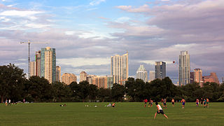
Zilker Metropolitan Park is a recreational area in south Austin, Texas at the juncture of Barton Creek and the Colorado River that comprises over 350 acres (142 ha) of publicly owned land. It is named after its benefactor, Andrew Jackson Zilker, who donated the land to the city in 1917. The land was developed into a park during the Great Depression in the 1930s. Today the park serves as a hub for many recreational activities and the hike and bike trail around Lady Bird Lake, both of which run next to the park. The large size of the park makes it a capable venue for large-scale events such as the Austin City Limits Music Festival and the Zilker Park Kite Festival. The park was listed in the National Register of Historic Places in 1997.

Barton Springs Pool is a recreational outdoor swimming pool that is filled entirely with water from nearby natural springs. It is located on the grounds of Zilker Park in Austin, Texas. The pool exists within the channel of Barton Creek and utilizes water from Main Barton Spring, the fourth largest spring in Texas. The pool is a popular venue for year-round swimming, as its temperature hovers between about 68 °F (20 °C) and 74 °F (23 °C) year round.

Barton Creek is a tributary that feeds the Colorado River as it flows through the Texas Hill Country. The creek passes through some of the more scenic areas in Greater Austin, surrounded in many parts by a greenbelt of protected lands that serves as a habitat for many indigenous species of flora and fauna. The creek passes through Barton Creek Greenbelt and is fed by Barton Springs.

Zilker is a neighborhood in south central Austin, Texas. It extends south of Lady Bird Lake, approximately bounded by the Union Pacific Railway to the southeast/south, Barton Skyway to the south, Rabb Road and Azie Morton Road to the west and Lady Bird Lake to the north.

Andrew Jackson Zilker (1858–1934) was a political figure and philanthropist in Austin, Texas, after whom Zilker Park was named. He was the last private owner of Barton Springs.

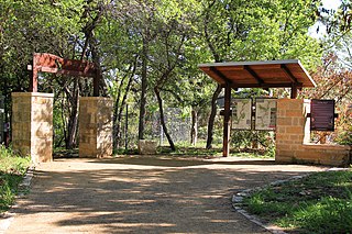
The Barton Creek Greenbelt located in Austin, Texas is managed by the City of Austin's Park and Recreation Department. The Greenbelt is a 7.25-mile (11.67 km) stretch of public land that begins at Zilker Park and stretches South/Southwest to the final section commonly referred to as "The Hill of Life" which ends in the Woods of Westlake subdivision. The Barton Creek Greenbelt consists of three areas: the Lower Greenbelt, the Upper Greenbelt, and the Barton Creek Wilderness Park and is characterized by large limestone cliffs, dense foliage, and shallow bodies of water.
Williamson Creek Greenbelt is a park and greenbelt located in the south of Austin, Texas, running along Williamson Creek and its tributaries.
Allandale, Austin, Texas is a neighborhood in North Central Austin, in the U.S. State of Texas known for its large lots, mature trees, and central location.

South Lamar, Austin, Texas is a neighborhood in south Austin, Texas, United States.
Westgate is a neighborhood in Austin, Texas, located southwest of the city's urban core. It includes ZIP code 78745.
Galindo is a neighborhood in Austin, Texas. The area covers part of ZIP code 78704 in south Austin.
Spyglass-Barton's Bluff is a neighborhood in Austin, Texas. It is located southwest of the city's urban core, and encompasses ZIP codes 78746 and 78704.
Hancock is a neighborhood in Austin, Texas. Located in North Central Austin, Hancock encompasses ZIP code 78751 and 78705.

Travis County has had two locations named Montopolis. The first was during the Republic of Texas period north of the Colorado River. Today's Montopolis is a neighborhood in Austin, Texas south of the river. Located southeast of the city's urban core, today's neighborhood is in ZIP code 78741. Montopolis is bounded by Lake Lady Bird on the north, by Grove Street and the Pleasant Valley neighborhood on the west, to the south by Texas State Highway 71, and by U.S. Route 183 on the east. The southeast corner abuts Austin-Bergstrom International Airport. Montopolis is in City Council District 3.
South River City is a community located in Austin, Texas. Also frequently called Travis Heights, the neighborhood is located south of the city's urban core, just below Lake Lady Bird in South Austin. The area encompasses a portion of ZIP code 78704.
East César Chávez is a neighborhood in Austin, Texas. It is located in the central-east part of Austin's urban core on the north bank of the Colorado River. The neighborhood encompasses much of ZIP code 78702.
The Violet Crown Trail is a 30-mile (48 km) pedestrian and cycling trail in Austin, Texas. Established in 2006 by the Hill Country Conservancy, the trail follows Barton Creek from Zilker Park and Mopac Expressway southwestward before finally terminating at the Lady Bird Johnson Wildflower Center. The trail is mostly made of decomposed granite but has various links that are only suitable for hiking.

