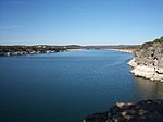
Lady Bird Lake is a river-like reservoir on the Colorado River in Austin, Texas, United States. The City of Austin created the reservoir in 1960 as a cooling pond for a new city power plant. The lake, which has a surface area of 416 acres (168 ha), is now used primarily for recreation and flood control. The reservoir is named in honor of former First Lady of the United States Lady Bird Johnson.
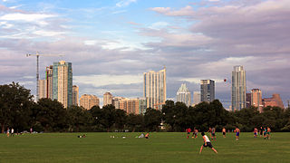
Zilker Metropolitan Park is a recreational area in south Austin, Texas, at the juncture of Barton Creek and the Colorado River that comprises over 350 acres (142 ha) of publicly owned land. It is named after its benefactor, Andrew Jackson Zilker, who donated the land to the city in 1917. The land was developed into a park during the Great Depression in the 1930s. Today the park serves as a hub for many recreational activities and the hike and bike trail around Lady Bird Lake, both of which run next to the park. The large size of the park makes it a capable venue for large-scale events such as the Austin City Limits Music Festival and the Zilker Park Kite Festival. The park was listed in the National Register of Historic Places in 1997.
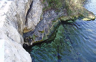
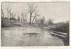
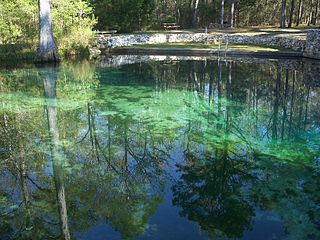
Barton Springs is a set of four natural water springs located at Barton Creek on the grounds of Zilker Park in Austin, Texas, resulting from water flowing through the Edwards Aquifer. The largest spring, Main Barton Spring, supplies water to Barton Springs Pool, a popular recreational destination in Austin. The smaller springs are located nearby, two with man-made structures built to contain and direct their flow. The springs are the only known habitat of the Barton Springs Salamander, an endangered species.
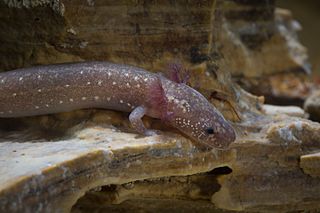
The Barton Springs salamander is an endangered lungless salamander. It is endemic to Texas, United States. It was first found in Barton Springs in Austin, but is now also known from other localities in the nearby Travis and Hays Counties. Barton Springs is located within Zilker Park which is situated in the Edwards Aquifer in Austin, Texas. Eliza Springs, located within Barton Springs, has one of the largest populations of Barton Springs salamanders.

The Wolf River is a 105-mile-long (169 km) alluvial river in western Tennessee and northern Mississippi, whose confluence with the Mississippi River was the site of various Chickasaw, French, Spanish and American communities that eventually became Memphis, Tennessee. It is estimated to be about 12,000 years old, formed by glacier runoff carving into the region's soft alluvial soil. It should not be confused with The Wolf River which flows primarily in Middle Tennessee and southern Kentucky. The Wolf River rises in the Holly Springs National Forest at Baker's Pond in Benton County, Mississippi, and flows northwest into Tennessee, before entering the Mississippi River north of downtown Memphis.

Barton Springs Pool is a recreational outdoor swimming pool in Austin, Texas, that is filled entirely by natural springs connected to the Edwards Aquifer. Located in Zilker Park, the pool exists within the channel of Barton Creek and uses water from Main Barton Spring, the fourth-largest spring in Texas. The pool is a popular venue for year-round swimming, as its temperature hovers between about 68 °F (20 °C) and 74 °F (23 °C) year-round. The pool's grassy hills are lined with mature shade trees.

Loop 360 is a 13.99-mile (22.51 km) loop route in Austin in the U.S. state of Texas. Loop 360, also known as the Capital of Texas Highway, is a scenic highway winding through the hills of West Austin. The road is described by the Texas Department of Transportation (TxDOT) as "a 4-lane depressed median arterial with at-grade signalized intersections". In 2021, the average daily traffic was 58,497 vehicles at the most traveled point, north of RM 2222.
Ponce de Leon Springs State Recreation Area is a Florida State Park in Holmes County, Florida, USA, located in the town of Ponce de Leon. The initial acquisition of the park on September 4, 1970, used funds from the Land Acquisition Trust Fund for the stated purpose of developing, operating, and maintaining the property. The plan was to develop the park for outdoor recreation, historic conservation, and to offer abundant opportunity for nature appreciation and wildlife viewing. Today, it grants park-goers the opportunities to swim in the spring and hike along the park's nature trails.

The San Marcos River rises from the San Marcos Springs, the location of the Meadows Center for Water and the Environment, in San Marcos, Texas. The springs are home to several threatened or endangered species, including the Texas blind salamander, fountain darter, and Texas wild rice. The river is a popular recreational area, and is frequented for tubing, canoeing, swimming, and fishing.

The Edwards Aquifer is one of the most prolific artesian aquifers in the world. Located on the eastern edge of the Edwards Plateau in the U.S. state of Texas, it is the source of drinking water for two million people, and is the primary water supply for agriculture and industry in the aquifer's region. Additionally, the Edwards Aquifer feeds the Comal and San Marcos Springs, provides springflow for recreational and downstream uses in the Nueces, San Antonio, Guadalupe, and San Marcos river basins, and is home to several unique and endangered species.
The Blue River is a 141-mile-long (227 km) tributary of the Red River in southern Oklahoma in the United States. Via the Red River, it is part of the watershed of the Mississippi River. According to the Geographic Names Information System, the river has also been known as Blue Creek. The Board on Geographic Names settled on "Blue River" as the stream's official name in 1977.
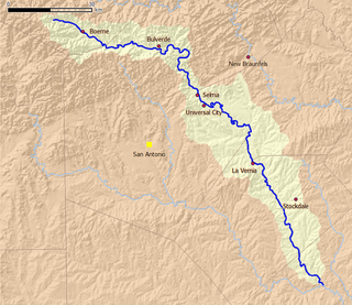
Cibolo Creek is a stream in South Central Texas that runs approximately 96 miles (154 km) from its source at Turkey Knob near Boerne, Texas, to its confluence with the San Antonio River in Karnes County. The creek is a tributary of the San Antonio River, at the easternmost part of its watershed.
Save Our Springs Alliance (SOS), originally called the Save Our Springs Legal Defense Fund, was a nonprofit corporation created to protect the citizen-drafted SOS Ordinance of 1992 to conserve Barton Springs in Austin, Texas. The ordinance was written by citizens in reaction to the city's "Composite Ordinance," which citizens regarded as insufficient to save Barton Springs.

The Shiawassee River in the U.S. state of Michigan drains an area of 1,201 square miles (3,110 km2) within Oakland, Genesee, Livingston, Shiawassee, Midland and Saginaw counties. It flows in a generally northerly direction for approximately 110 miles (180 km) from its source to its confluence with the Tittabawassee River creating the Saginaw River, which drains into Saginaw Bay of Lake Huron.

The Barton Creek Greenbelt in Austin, Texas is managed by the City of Austin's Park and Recreation Department. The Greenbelt is a 7.25-mile (11.67 km) stretch of public land spanning from Zilker Park west to the Lost Creek neighborhood. The Barton Creek Greenbelt runs parallel to the first 6.5 miles of Barton Creek before ending on a steep .75 mile hill commonly referred to as the hill of life. The Barton Creek Greenbelt consists of three areas: the Barton Creek Wilderness Park, the Upper Greenbelt, and the Lower Greenbelt. It is characterized by large limestone cliffs, dense foliage, and shallow bodies of water.

Bull Creek is a tributary of the Colorado River originating in the Texas Hill Country. The creek passes through some of the more scenic areas in the Austin region and forms a greenbelt that is the habitat for many indigenous species of flora and fauna. It runs beneath steep slopes and benches surfaced with shallow clay loams that support ashe juniper, escarpment live oak, mesquite, and grasses.

Barton Hills is a neighborhood in Austin, Texas. It is located in south Austin, and encompasses part of ZIP code 78704.

The Land Conservancy of San Luis Obispo County (LCSLO) is a non-profit land trust organization that has been operating in San Luis Obispo County, California since 1984. The LCSLO is dedicated to voluntary, collaborative preservation, and improvement of lands that hold significant scenic, agricultural, habitat, and cultural values. Their work aims to benefit both local communities and wildlife.

Balcones Canyonlands is a national wildlife refuge located in the Texas Hill Country to the northwest of Lago Vista, Texas. The refuge was formed in 1992 to conserve habitat for two endangered songbirds, the golden-cheeked warbler and the black-capped vireo, and to preserve Texas Hill Country habitat for numerous other wildlife species. The refuge augments a similarly named preserve in Austin called the Balcones Canyonlands Preserve.

Shoal Creek is a stream and an urban watershed in Austin, Texas, United States.