Lost Creek, Texas

Last updated

Lost Creek, Texas
CDP
Lost-creek-square.jpg
Lost Creek entrance monument on Lost Creek Blvd at Capital of Texas Highway.
Lost Creek, Texas
Coordinates: 30°17′40″N97°50′44″W / 30.29444°N 97.84556°W / 30.29444; -97.84556
Country United States
State Texas
County Travis
Area
  Total3.3 sq mi (8.5 km2)
  Land3.3 sq mi (8.5 km2)
  Water0.0 sq mi (0.0 km2)
Elevation
[1]
823 ft (251 m)
Population
 (2020)
  Total1,276
  Density390/sq mi (150/km2)
Time zone UTC-6 (Central (CST))
  Summer (DST) UTC-5 (CDT)
Zip Code
78746
FIPS code 48-44166 [2]
GNIS feature ID1867554 [1]

Lost Creek is an affluent upper-middle-class neighborhood and census-designated place (CDP) in Travis County, Texas, United States. The population was 1,276 at the 2020 census. The census tract is bordered by Capital of Texas Highway to the east, Barton Creek to the south, Barton Creek Boulevard to the west, and Bee Caves Road to the north. The Lost Creek CDP encompasses several small neighborhoods—Parkstone, Woods of Westlake, Camelot, and Knollwood—as well as the largest and most populous Lost Creek neighborhood.

Contents

The neighborhood is named after a secluded section of Barton Creek away from more popular portions downstream that include Barton Springs and Zilker Park.

Suburban residential development began in the late 1970s and continued for over three decades. Lost Creek is almost completely built-out. Lost Creek also encompasses a commercial area bordering Bee Caves Road and Capital of Texas Highway. Businesses occupying these buildings include Capital One Bank, Wells Fargo Bank, and Apple Inc. Lost Creek was annexed by the City of Austin in December 2015 and was dis-annexed in May 2024 [3] under the provisions of HB 3053 passed during the 88th Texas Legislature [4]

Geography

Lost Creek is located at 30°17′40″N97°50′44″W / 30.29444°N 97.84556°W / 30.29444; -97.84556 (30.294431, -97.845459). The CDP has a total area of 3.3 square miles (8.5 km2), all land. [5]

Schools

Lost Creek lies completely within the Eanes Independent School District. [6] Students residing within Lost Creek attend Forest Trail Elementary, West Ridge Middle School, and Westlake High School.

Demographics

Historical population
CensusPop.Note
2000 4,729
2010 4,509−4.7%
2020 1,276−71.7%
US Decennial Census [7]
2020 Census [8]

As of the census [2] of 2000, there were 4,729 people, 1,562 households, and 1,379 families residing in the CDP. The population density was 1,509.6 inhabitants per square mile (582.9/km2). There were 1,584 housing units at an average density of 505.7 per square mile (195.3/km2). The racial makeup of the CDP was 92.20% White, 0.51% African American, 0.27% Native American, 4.88% Asian, 0.57% from other races, and 1.56% from two or more races. Hispanic or Latino of any race were 3.68% of the population.

There were 1,562 households, out of which 52.0% had children under the age of 18 living with them, 80.2% were married couples living together, 6.2% had a female householder with no husband present, and 11.7% were non-families. 9.5% of all households were made up of individuals, and 2.4% had someone living alone who was 65 years of age or older. The average household size was 3.03 and the average family size was 3.24.

In the CDP, the population was spread out, with 32.5% under the age of 18, 4.8% from 18 to 24, 22.9% from 25 to 44, 33.9% from 45 to 64, and 5.9% who were 65 years of age or older. The median age was 40 years. For every 100 females, there were 102.2 males. For every 100 females age 18 and over, there were 94.9 males.

The median income for a household in the CDP was $116,500, and the median income for a family was $121,069. Males had a median income of $94,013 versus $45,804 for females. The per capita income for the CDP was $52,147. None of the families and 1.2% of the population were living below the poverty line, including no under eighteens and none of those over 64.

Adult residents of Lost Creek are extremely well educated. In 2014, Business Insider declared Lost Creek to be The Most Educated Place In Texas and seventh most educated place in the United States. [9] based on its analysis of census data.

Related Research Articles

<span class="mw-page-title-main">Hunter's Creek, Florida</span> Census-designated place in Florida, United States

Hunter's Creek is a master planned, unincorporated community and census-designated place in Orange County, Florida, United States. It is part of the Orlando–Kissimmee–Sanford, Florida Metropolitan Statistical Area. The population was 14,321 at the 2010 census. It has grown up around a large planned community named Hunter's Creek, though the CDP name given by the United States Census Bureau lacks the apostrophe.

Lorane is a census-designated place (CDP) in Exeter Township, Berks County, Pennsylvania. The population was 4,236 at the 2010 census. Located on the Schuylkill River, US Route 422 runs through the town.

<span class="mw-page-title-main">Wyldwood, Texas</span> CDP in Texas, United States

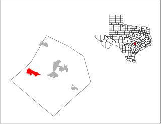
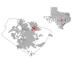
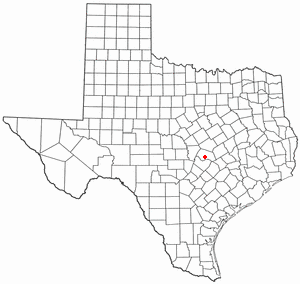
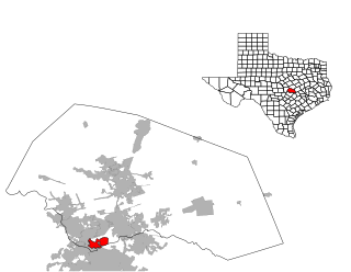
Wyldwood is a census-designated place (CDP) in Bastrop County, Texas, United States. The population was 3,694 at the 2020 census.

<span class="mw-page-title-main">Homestead Meadows North, Texas</span> Census-designated place in Texas, United States

Homestead Meadows North is a census-designated place (CDP) in El Paso County, Texas, United States. The population was 5,124 at the 2010 census. It is part of the El Paso Metropolitan Statistical Area. The ZIP Code encompassing the CDP area is 79938.

<span class="mw-page-title-main">Geronimo, Texas</span> Census-designated place in Texas, United States

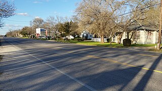
Geronimo is an unincorporated community and census-designated place (CDP) in Guadalupe County, Texas, United States. The population was 1,032 at the 2010 census, up from 619 at the 2000 census. It is part of the San Antonio Metropolitan Statistical Area.

<span class="mw-page-title-main">La Paloma-Lost Creek, Texas</span> CDP in Texas, United States

La Paloma-Lost Creek is a census-designated place (CDP) in Nueces County, Texas, United States. The population was 408 at the 2010 census, up from 323 at the 2000 census.

<span class="mw-page-title-main">Roma Creek, Texas</span> CDP in Texas, United States

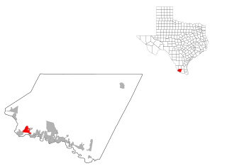
Roma Creek is a former census-designated place (CDP) in Starr County, Texas, United States. The population was 350 at the 2010 census down from 610 at the 2000 census.

<span class="mw-page-title-main">Grape Creek, Texas</span> CDP in Texas, United States

Grape Creek is a census-designated place (CDP) in Tom Green County, Texas, United States. It is part of the San Angelo, Texas Metropolitan Statistical Area. The population of Grape Creek was 3,154 at the 2010 census.

<span class="mw-page-title-main">Barton Creek, Texas</span> CDP in Texas, United States

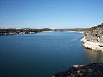
Barton Creek is a census-designated place (CDP) in Travis County, Texas, United States. As of the 2020 census, the CDP population was 3,356.

<span class="mw-page-title-main">Garfield, Texas</span> CDP in Texas, United States

Garfield is a census-designated place (CDP) in Travis County, Texas, United States. As of the 2020 census, the CDP population was 1,825.

<span class="mw-page-title-main">Hudson Bend, Texas</span> CDP in Texas, United States

Hudson Bend is a census-designated place (CDP) in Travis County, Texas, United States. The population was 4,005 at the 2020 census.

Onion Creek is a neighborhood in Austin, Texas, United States.

<span class="mw-page-title-main">Shady Hollow, Texas</span> CDP in Texas, United States

Shady Hollow is a census-designated place (CDP) in southwestern Travis County, Texas, United States, and is partially in the City of Austin. It is located ten miles (16 km) southwest of Downtown Austin, near the Travis/Hays county line. The population was 4,822 at the 2020 census.

Wells Branch is a census-designated place (CDP) in Travis County, Texas, United States. The population was 14,000 at the 2020 census.

<span class="mw-page-title-main">West Lake Hills, Texas</span> City in Texas, United States

West Lake Hills is a city in Travis County, Texas, United States. The population was 3,444 at the 2020 census. The city developed rapidly in the 1970s and 1980s on the south side of the Colorado River.

<span class="mw-page-title-main">Windemere, Texas</span> Former CDP in Texas, United States

Windermere is a former census-designated place (CDP) in Travis County, Texas, United States. The population was 1,037 at the 2010 census. It has since largely been annexed by the city of Pflugerville.

<span class="mw-page-title-main">Brushy Creek, Williamson County, Texas</span> CDP in Texas, United States

Brushy Creek is a census-designated place (CDP) in Williamson County, Texas, United States. The population was 22,519 at the 2020 census.

Anderson Mill is a neighborhood of Austin and a former census-designated place (CDP) in Travis and Williamson counties in the U.S. state of Texas. The population was 7,199 at the 2010 census.

<span class="mw-page-title-main">Jollyville, Texas</span> Place in Texas, United States

Jollyville is a neighborhood in the northern part of Austin, Texas, United States. In 2010 it was a census-designated place (CDP) in Travis and Williamson counties, but has since been annexed by Austin. The population of the CDP was 16,151 at the 2010 census.

Spyglass-Barton's Bluff is a neighborhood in Austin, Texas. It is located southwest of the city's urban core, and encompasses ZIP codes 78746 and 78704.

References

  1. 1 2 U.S. Geological Survey Geographic Names Information System: Lost Creek, Texas
  2. 1 2 "U.S. Census website". United States Census Bureau . Retrieved January 31, 2008.
  3. https://www.fox7austin.com/news/election-austin-dis-annexation-malone-lost-creek-texas-property-taxes
  4. https://www.texaspolicy.com/will-voters-decide-to-leave-austin/
  5. "Lost Creek, Texas :: Boundary Map of Lost Creek, Texas".
  6. "2020 CENSUS - SCHOOL DISTRICT REFERENCE MAP: Travis County, TX" (PDF). U.S. Census Bureau . Retrieved May 21, 2021.
  7. "US Gazetteer files: 2010, 2000, and 1990". United States Census Bureau. February 12, 2011. Retrieved May 15, 2024.
  8. "Census Bureau profile: Lost Creek, Texas". United States Census Bureau. May 2023. Retrieved May 15, 2024.
  9. "West Austin: The most educated place in Texas — and top 10 in U.S." Austin Business Journal. September 11, 2014. Retrieved January 11, 2015.