Hudson Bend, Texas

Last updated

Hudson Bend, Texas
CDP
Travis County HudsonBend.svg
Coordinates: 30°24′55″N97°55′19″W / 30.41528°N 97.92194°W / 30.41528; -97.92194
Country United States
State Texas
County Travis
Area
  Total6.7 sq mi (17.3 km2)
  Land4.0 sq mi (10.3 km2)
  Water2.7 sq mi (7.0 km2)
Elevation
755 ft (230 m)
Population
 (2020)
  Total4,005
  Density600/sq mi (230/km2)
Time zone UTC-6 (Central (CST))
  Summer (DST) UTC-5 (CDT)
ZIP code
78734
Area code 512
FIPS code 48-35253 [1]
GNIS feature ID1852714 [2]

Hudson Bend is a census-designated place (CDP) in Travis County, Texas, United States. The population was 4,005 at the 2020 census.

Contents

Geography

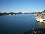
Lake Travis is located near Hudson Bend Pacebend.jpg
Lake Travis is located near Hudson Bend

Hudson Bend is located at 30°24′55″N97°55′19″W / 30.41528°N 97.92194°W / 30.41528; -97.92194 (30.415400, -97.921973), [3] 16 miles (26 km) northwest of Austin on Lake Travis.

According to the United States Census Bureau, the CDP has a total area of 6.7 square miles (17.3 km2), of which 4.0 square miles (10.3 km2) is land and 2.7 square miles (7.0 km2) (40.27%) is water.

Demographics

Historical population
CensusPop.Note
2000 2,369
2010 2,98125.8%
2020 4,00534.4%
US Decennial Census [4]
2020 Census [5]

As of the census [1] of 2000, there were 2,369 people, 1,065 households, and 614 families residing in the CDP. The population density was 594.4 inhabitants per square mile (229.5/km2). There were 1,225 housing units at an average density of 307.4 per square mile (118.7/km2). The racial makeup of the CDP was 94.30% White, 0.13% African American, 0.76% Native American, 0.51% Asian, 0.04% Pacific Islander, 3.00% from other races, and 1.27% from two or more races. Hispanic or Latino of any race were 6.75% of the population.

There were 1,065 households, out of which 25.5% had children under the age of 18 living with them, 47.7% were married couples living together, 6.2% had a female householder with no husband present, and 42.3% were non-families. 32.3% of all households were made up of individuals, and 5.1% had someone living alone who was 65 years of age or older. The average household size was 2.22 and the average family size was 2.82.

In the CDP, the population was spread out, with 20.6% under the age of 18, 4.9% from 18 to 24, 33.0% from 25 to 44, 32.0% from 45 to 64, and 9.4% who were 65 years of age or older. The median age was 42 years. For every 100 females, there were 117.3 males. For every 100 females age 18 and over, there were 116.8 males.

The median income for a household in the CDP was $61,406, and the median income for a family was $77,463. Males had a median income of $42,679 versus $34,338 for females. The per capita income for the CDP was $37,560. About 1.5% of families and 3.5% of the population were below the poverty line, including 2.9% of those under age 18 and 1.5% of those age 65 or over.

Education

Hudson Bend is served by the Lake Travis Independent School District (LTISD). [6]

Public library

The Lake Travis Community Library (LTCL) in Lakeway serves Hudson Bend. It originally opened in Lake Travis High School in 1985. Area voters approved the creation of the library district serving the library was created in May 2004. Haythem Dawlett donated the land for the library in March 2011, and the library moved into the current location in February 2013. [9]

Related Research Articles

<span class="mw-page-title-main">Egypt Lake-Leto, Florida</span> Census-designated place in Florida, United States

Egypt Lake-Leto is a census-designated place (CDP) in an unincorporated part of Hillsborough County, Florida, United States. The CDP is located just north of Tampa International Airport. It is part of the Tampa Bay area. As of the 2020 US census, the population had 36,644 residents.

<span class="mw-page-title-main">Lakes of the Four Seasons, Indiana</span> Census-designated place in Indiana, United States

Lakes of the Four Seasons is a census-designated place (CDP) in Lake and Porter counties in the U.S. state of Indiana. The population was 7,033 at the 2010 census.
<span class="mw-page-title-main">Forest Oaks, North Carolina</span> Census-designated place in North Carolina, United States

Forest Oaks is a census-designated place (CDP) in Guilford County, North Carolina, United States. The population was 3,890 as of the 2010 census, up from 3,241 in 2000.

<span class="mw-page-title-main">Lake Darby, Ohio</span> Census-designated place in Ohio, United States

Lake Darby is an unincorporated community and census-designated place in Franklin County, Ohio, United States, located mostly in Prairie Township and partly in Brown Township. It is more commonly known among locals as Darby Estates, which is also the name of the older housing development there, with the newer development called "West Point". As of the 2020 census, the CDP had a population of 4,731.
<span class="mw-page-title-main">Devola, Ohio</span> CDP in Ohio, United States

Devola is a census-designated place (CDP) in Washington County, Ohio, United States, along the Muskingum River. It is part of the Parkersburg-Marietta-Vienna, WV-OH Metropolitan Statistical Area. The population was 2,639 at the 2020 census.
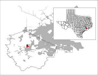
<span class="mw-page-title-main">Cumings, Texas</span> Census-designated place in Texas, United States

Cumings is an unincorporated community and census-designated place (CDP) in Fort Bend County, Texas, United States. The population was 2,207 at the 2020 census, significantly up from 981 at the 2010 census.

<span class="mw-page-title-main">New Territory, Sugar Land, Texas</span> Place in Texas, United States

New Territory is a master-planned community within the city of Sugar Land, Texas, United States. It was formerly a census-designated place (CDP) and in the extraterritorial jurisdiction of Sugar Land, in unincorporated Fort Bend County. It was annexed into Sugar Land on December 12, 2017. The population was 15,186 at the 2010 census, up from 13,861 at the 2000 census.

<span class="mw-page-title-main">Barton Creek, Texas</span> CDP in Texas, United States

Barton Creek is a census-designated place (CDP) in Travis County, Texas, United States. As of the 2020 census, the CDP population was 3,356.
<span class="mw-page-title-main">Bee Cave, Texas</span> City in Texas, United States

Bee Cave is a city located in Travis County, Texas, United States. Its population was 9,144 as of the 2020 census.
<span class="mw-page-title-main">Briarcliff, Texas</span> Village in Texas, United States

Briarcliff is a village in Travis County, Texas, United States. The population was 2,062 at the 2020 census.

<span class="mw-page-title-main">Garfield, Texas</span> CDP in Texas, United States

Garfield is a census-designated place (CDP) in Travis County, Texas, United States. As of the 2020 census, the CDP population was 1,825.

<span class="mw-page-title-main">Lakeway, Texas</span> City in Texas, United States

Lakeway is a city in Travis County, Texas, United States. The population was 19,189 at the 2020 census, an increase over the figure of 11,391 tabulated in 2010. The city is located next to Lake Travis. It is an exurb in Greater Austin.

<span class="mw-page-title-main">Lost Creek, Texas</span> CDP in Texas, United States

Lost Creek is an affluent upper-middle-class neighborhood and census-designated place (CDP) in Travis County, Texas, United States. The population was 1,276 at the 2020 census. The census tract is bordered by Capital of Texas Highway to the east, Barton Creek to the south, Barton Creek Boulevard to the west, and Bee Caves Road to the north. The Lost Creek CDP encompasses several small neighborhoods—Parkstone, Woods of Westlake, Camelot, and Knollwood—as well as the largest and most populous Lost Creek neighborhood.

<span class="mw-page-title-main">Shady Hollow, Texas</span> CDP in Texas, United States

Shady Hollow is a census-designated place (CDP) in southwestern Travis County, Texas, United States, and is partially in the City of Austin. It is located ten miles (16 km) southwest of Downtown Austin, near the Travis/Hays county line. The population was 4,822 at the 2020 census.

<span class="mw-page-title-main">The Hills, Texas</span> Type B General Law City in Texas, United States

The Hills is a village in Travis County, Texas, United States. The population was 2,613 at the 2020 census, making it the largest village in Texas. It is a suburb of Austin.

Wells Branch is a census-designated place (CDP) in Travis County, Texas, United States. The population was 14,000 at the 2020 census.
<span class="mw-page-title-main">Windemere, Texas</span> Former CDP in Texas, United States

Windermere is a former census-designated place (CDP) in Travis County, Texas, United States. The population was 1,037 at the 2010 census. It has since largely been annexed by the city of Pflugerville.
<span class="mw-page-title-main">Jollyville, Texas</span> Place in Texas, United States

Jollyville is a neighborhood in the northern part of Austin, Texas, United States. In 2010 it was a census-designated place (CDP) in Travis and Williamson counties, but has since been annexed by Austin. The population of the CDP was 16,151 at the 2010 census.

Greenville is a hamlet and census-designated place (CDP) in the town of Greenville, in Greene County, New York, United States. The population of the CDP was 688 at the 2020 census, out of a total 3,741 people in the town as a whole.

Bainbridge is a census-designated place (CDP) in Bainbridge Township, Geauga County, Ohio, United States. As of the 2020 census, the CDP had a population of 9,242.

References

  1. 1 2 "U.S. Census website". United States Census Bureau . Retrieved January 31, 2008.
  2. "US Board on Geographic Names". United States Geological Survey. October 25, 2007. Retrieved January 31, 2008.
  3. "US Gazetteer files: 2010, 2000, and 1990". United States Census Bureau. February 12, 2011. Retrieved April 23, 2011.
  4. "US Gazetteer files: 2010, 2000, and 1990". United States Census Bureau. February 12, 2011. Retrieved May 15, 2024.
  5. "Census Bureau profile: Hudson Bend, Texas". United States Census Bureau. May 2023. Retrieved May 15, 2024.
  6. Hudson Bend CDP map. U.S. Census Bureau. Retrieved on December 30, 2016.
  7. "Elementary School Attendance Zone Boundaries Archived 2016-12-29 at the Wayback Machine ." Lake Travis Independent School District. Retrieved on December 30, 2016.
  8. "Middle School Attendance Zone Boundaries Archived 2015-05-31 at the Wayback Machine ." Lake Travis Independent School District. Retrieved on December 30, 2016.
  9. "History." Lake Travis Community Library. Retrieved on April 13, 2017. "Lake Travis Community Library 1938 Lohmans Crossing Austin, TX 78734" - Map of library district