Marble Falls, Texas | |
|---|---|
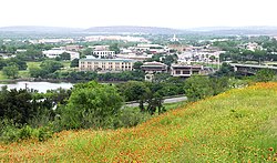 Hill view of Marble Falls, 2007 | |
| Nickname: Marble | |
| Motto: "Lakeside Charm with Downtown Flair" | |
 Location of Marble Falls, Texas | |
 | |
| Coordinates: 30°34′N98°17′W / 30.567°N 98.283°W | |
| Country | United States |
| State | Texas |
| County | Burnet |
| Area | |
• Total | 15.16 sq mi (39.26 km2) |
| • Land | 14.51 sq mi (37.59 km2) |
| • Water | 0.64 sq mi (1.67 km2) |
| Elevation | 801 ft (244 m) |
| Population (2020) | |
• Total | 7,037 |
| • Density | 484.9/sq mi (187.2/km2) |
| Time zone | UTC-6 (Central (CST)) |
| • Summer (DST) | UTC-5 (CDT) |
| ZIP Codes | 78654, 78657 |
| Area code | 830 |
| FIPS code | 48-46584 [3] |
| GNIS feature ID | 2411030 [2] |
| Website | marblefallstx |
Marble Falls is a city in Burnet County, Texas, United States. As of the 2020 United States Census, the city population was 7,037. The 2024 population was estimated to be 9,413. Lake Marble Falls is part of the Highland Lakes on the Colorado River, the largest chain of lakes in Texas. [4] Marble Falls was founded by Adam Rankin Johnson [5] in 1887, a former Indian fighter and Confederate general.


