
The Texas Longhorn is an American breed of beef cattle, characterized by its long horns, which can span more than 8 ft (2.4 m) from tip to tip. It derives from cattle brought from the Iberian Peninsula to the Americas by Spanish conquistadores from the time of the Second Voyage of Christopher Columbus until about 1512. For hundreds of years the cattle lived a semi-feral existence on the rangelands; they have a higher tolerance of heat and drought than most European breeds. It can be of any color or mix of colors. In some 40% of the cattle it is some shade of red, often a light red; the only shade of red not seen is the deep color typical of the Hereford.

Cass Gilbert was an American architect. An early proponent of skyscrapers, his works include the Woolworth Building, the United States Supreme Court building, the state capitols of Minnesota, Arkansas, and West Virginia, the Detroit Public Library, the Saint Louis Art Museum and Public Library. His public buildings in the Beaux Arts style reflect the optimistic American sense that the nation was heir to Greek democracy, Roman law and Renaissance humanism. Gilbert's achievements were recognized in his lifetime; he served as president of the American Institute of Architects in 1908–09.

Burnet County is a county located on the Edwards Plateau in the U.S. state of Texas. As of the 2020 census, its population was 49,130. Its county seat is Burnet. The county was founded in 1852 and later organized in 1854. It is named for David Gouverneur Burnet, the first (provisional) president of the Republic of Texas. The name of the county is pronounced with the emphasis or accent on the first syllable, just as is the case with its namesake.
The Llano Uplift is a geologically ancient, low geologic dome that is about 90 miles (140 km) in diameter and located mostly in Llano, Mason, San Saba, Gillespie, and Blanco counties, Texas. It consists of an island-like exposure of Precambrian igneous and metamorphic rocks surrounded by outcrops of Paleozoic and Cretaceous sedimentary strata. At their widest, the exposed Precambrian rocks extend about 65 miles (105 km) westward from the valley of the Colorado River and beneath a broad, gentle topographic basin drained by the Llano River. The subdued topographic basin is underlain by Precambrian rocks and bordered by a discontinuous rim of flat-topped hills. These hills are the dissected edge of the Edwards Plateau, which consist of overlying Cretaceous sedimentary strata. Within this basin and along its margin are down-faulted blocks and erosional remnants of Paleozoic strata which form prominent hills.

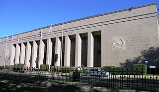
The Texas State Capitol is the capitol and seat of government of the American state of Texas. Located in downtown Austin, Texas, the structure houses the offices and chambers of the Texas Legislature and of the Governor of Texas. Designed in 1881 by architect Elijah E. Myers, it was constructed from 1882 to 1888 under the direction of civil engineer Reuben Lindsay Walker. A $75 million underground extension was completed in 1993. The building was added to the National Register of Historic Places in 1970 and recognized as a National Historic Landmark in 1986.
The Battle of Bayou Fourche, also known as the Battle of Little Rock and the Engagement at Bayou Fourche, took place on September 10, 1863, in Pulaski County, Arkansas, and was the final battle of the Little Rock Campaign, also known as the Advance upon Little Rock, which began on August 1 to capture the capital. Union Major-General Frederick Steele's "Arkansas expedition," 15,000 strong, defeated Confederate Major-General Sterling Price's 7,749 man District of Arkansas. The Confederate forces took up defensive positions in and around the city of Little Rock. The area of the battle was bisected by the Arkansas, with the Bayou Fourche forming an additional obstacle to the south-east of Little Rock. Steele divided his army into two main sections in order to attack from both the east and south-east. There was fierce fighting at river crossing points and, following the crossing of the Bayou Fourche to the east of the city, the "Arkansas expedition" entered Little Rock and organized Confederate resistance collapsed. Price's army was able to escape capture.
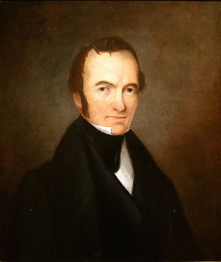
John Ireland was the 18th Governor of Texas from 1883 to 1887. During Ireland's term, the University of Texas was established, and construction on the Texas State Capitol began. Ireland is credited with the selection of local pink granite as the construction material.

India possesses a wide spectrum of dimensional stones that include granite, marble, sandstone, limestone, slate, and quartzite, in various parts of the country.
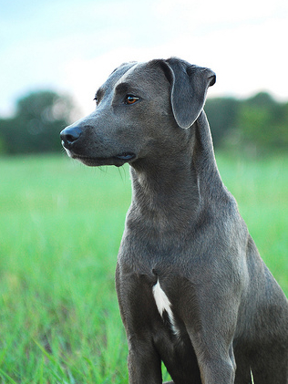
The Lacy Dog or Blue Lacy Dog is a breed of working dog that originated in the State of Texas in the mid-19th century. The Lacy was first recognized in 2001 by the Texas Senate. In Senate Resolution No. 436, the 77th Legislature honored the Lacy as "a true Texas breed." In 2005, in House Concurrent Resolution No. 108, the 79th Legislature called the Lacy "a Texas original; the only dog breed to have originated in this state." In June 2005, Governor Rick Perry signed the legislation adopting the Blue Lacy as "the official State Dog Breed of Texas". As expected, the vast majority of Lacy dogs are found in Texas. However, as the breed becomes more recognized, breeding populations are being established across the United States, Canada, and most recently in Europe.

The government of Texas operates under the Constitution of Texas and consists of a unitary democratic state government operating under a presidential system that uses the Dillon Rule, as well as governments at the county and municipal levels.
After declaring its independence from Mexico in March, 1836, the Republic of Texas had numerous locations as its seat of government. This being seen as a problem attempts were made to select a permanent site for the capital. January, 1839, with Mirabeau B. Lamar as the newly elected president, a site selection commission of five commissioners was formed. Edward Burleson had surveyed the planned townsite of Waterloo, near the mouth of Shoal Creek on the Colorado River, in 1838; it was incorporated January 1839. By April of that year the site selection commission had selected Waterloo to be the new capital. A bill previously passed by Congress in May, 1838, specified that any site selected as the new capital would be named Austin, after the late Stephen F. Austin; hence Waterloo upon selection as the capital was renamed Austin. The first lots in Austin went on sale August 1839.
The Texas State Library and Archives Commission (TSLAC) refers to the agency in the state of Texas that assists the people of Texas to effectively use information, archival resources, public records and library materials to improve their lives, the lives of their families, and their communities. The agency is charged with overseeing statewide library programs, meeting the reading-related needs of Texans with disabilities, and preserving and providing access to significant Texas documents.

The Austin–Round Rock–San Marcos metropolitan statistical area, or Greater Austin, is a five-county metropolitan area in the U.S. state of Texas, as defined by the Office of Management and Budget. The metropolitan area is situated in Central Texas on the western edge of the American South and on the eastern edge of the American Southwest, and borders Greater San Antonio to the south.
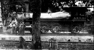
The Austin and Northwestern Railroad began construction on a rail line west of Austin, Texas, USA, toward Llano on April 20, 1881. The railroad was originally built as a 3 ft narrow gauge line with plans to connect to the Texas and Pacific Railway at Abilene. Construction reached Burnet, Texas, by 1882 and the line was later extended to Granite Mountain by 1885 - when the railroad was contracted to haul pink granite for the new Texas State Capitol building in Austin. The company later extended its line 2.3 miles (3.7 km) to Marble Falls by using the charter of the Granite Mountain and Marble Falls City Railroad. Due to a bend in the tracks, trains would occasionally derail, accidentally dumping some of the pink granite. The rocks which remain are a local point of interest.

600 Congress is a high-rise office building located at the northwest corner of West 6th Street and Congress Avenue in the Financial District of Downtown Austin, the state capital of Texas. Standing 400 feet tall and containing 32 floors, it is currently the 12th tallest building in Austin, tied with the Four Seasons Residences. The construction of One American Center was completed in 1984 and was developed by Rust Properties. It was the tallest building in Austin until the finishing of the Frost Bank Tower in 2003. In 2017, One American Center was rebranded as 600 Congress.

Marble Falls is a city in Burnet County, Texas, United States. As of the 2020 United States Census, the city population was 7,033. Lake Marble Falls is part of the Highland Lakes on the Colorado River, the largest chain of lakes in Texas. Marble Falls was founded by Adam Rankin Johnson in 1887, a former Indian fighter and Confederate general.

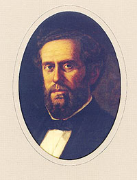
Hermann Lungkwitz (1813–1891) was a 19th-century German-born Texas romantic landscape artist and photographer whose work became the first pictorial record of the Texas Hill Country.
The Lorenzo de Zavala State Archives and Library Building is a state library and historic landmark in Downtown Austin, Texas.

Waters Park, Texas was a village located eight miles north of downtown Austin, Texas defined by the boundaries of Farm to Market Road 1325, MoPac, and the Southern Pacific Railroad. It is now part of the City of Austin.


