
Travis County is located in Central Texas. As of the 2020 census, the population was 1,290,188. It is the fifth-most populous county in Texas. Its county seat and most populous city is Austin, the capital of Texas. The county was established in 1840 and is named in honor of William Barret Travis, the commander of the Republic of Texas forces at the Battle of the Alamo. Travis County is part of the Austin–Round Rock–Georgetown Metropolitan Statistical Area. It is located along the Balcones Fault, the boundary between the Edwards Plateau to the west and the Blackland Prairie to the east.

Tom Green County is a county located on the Edwards Plateau in the U.S. state of Texas. As of the 2020 census, its population was 120,003. Its county seat is San Angelo. The county was created in 1874 and organized the following year. It is named for Thomas Green, who was a Confederate soldier and lawyer. Tom Green County is included in the San Angelo metropolitan statistical area; the county is home to Goodfellow Air Force Base, as well as Angelo State University, part of the Texas Tech University System.

Sterling County is a county located on the Edwards Plateau in the U.S. state of Texas. As of the 2020 census, its population was 1,372, making it the ninth-least populous county in Texas. Its county seat is Sterling City. The county is named for W. S. Sterling, an early settler in the area. Sterling County was one of 30 prohibition, or entirely dry, counties in the state of Texas, but is now a moist county.

Menard County is a county located on the Edwards Plateau in the U.S. state of Texas. As of the 2020 census, its population was 1,962. The county seat is Menard. The county was created in 1858 and later organized in 1871. It is named for Michel Branamour Menard, the founder of Galveston, Texas.

Concho County is a county located on the Edwards Plateau in the U.S. state of Texas. At the 2020 census, the population was 3,303. Its county seat is Paint Rock. The county was founded in 1858 and later organized in 1879. It is named for the Concho River.

Coke County is a county located on the Edwards Plateau in the U.S. state of Texas. As of the 2020 census, its population was 3,285. Its county seat is Robert Lee. The county was founded in 1889 and is named for Richard Coke, the 15th governor of Texas and later a U.S. senator. Coke County was one of 46 prohibition, or entirely dry, counties in the State of Texas, but passed a law allowing the sale of beer and wine in 2005.

Sterling City is the county seat of Sterling County, Texas, United States. Its population was 1,121 at the 2020 census.
Christoval is a census-designated place (CDP) in Tom Green County, Texas, United States. Its population was 504 at the 2010 census. It is part of the San Angelo, Texas, metropolitan statistical area.

San Angelo is a city in and the county seat of Tom Green County, Texas, United States. Its location is in the Concho Valley, a region of West Texas between the Permian Basin to the northwest, Chihuahuan Desert to the southwest, Osage Plains to the northeast, and Central Texas to the southeast. According to the 2020 United States Census, San Angelo had a total population of 99,893. It is the principal city and center of the San Angelo metropolitan area, which had a population of 121,516.

The Edwards Plateau is a geographic region forming the crossroads of Central, South and West Texas, United States. It is named in honor of Haden Edwards. It is bounded by the Balcones Fault to the south and east; the Llano Uplift and the Llano Estacado to the north; and the Pecos River and Chihuahuan Desert to the west. San Angelo, Austin, San Antonio and Del Rio roughly outline the area. The plateau, especially its southeast portion, is also known as the Texas Hill Country.
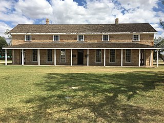
Fort Concho is a former United States Army installation and National Historic Landmark District located in San Angelo, Texas. It was established in November 1867 at the confluence of the North and South Concho Rivers, on the routes of the Butterfield Overland Mail Route and Goodnight–Loving Trail, and was an active military base for the next 22 years. Fort Concho was the principal base of the 4th Cavalry from 1867 to 1875 and then the "Buffalo Soldiers" of the 10th Cavalry from 1875 to 1882. The troops stationed at Fort Concho participated in Ranald S. Mackenzie's 1872 campaign, the Red River War in 1874, and the Victorio Campaign of 1879–1880.

The Edwards Aquifer is one of the most prolific artesian aquifers in the world. Located on the eastern edge of the Edwards Plateau in the U.S. state of Texas, it is the source of drinking water for two million people, and is the primary water supply for agriculture and industry in the aquifer's region. Additionally, the Edwards Aquifer feeds the Comal and San Marcos Springs, provides springflow for recreational and downstream uses in the Nueces, San Antonio, Guadalupe, and San Marcos river basins, and is home to several unique and endangered species.
Ben Ficklin (Benficklin), Texas is a ghost town and the former county seat of Tom Green County from 1875 to 1882. It was located 5 miles (8 km) south of Fort Concho on the east bank of the South Concho River.

The Concho Valley Council of Governments (CVCOG) is a voluntary association of cities, counties and special districts in West Texas, United States.

The South Concho River is one of the few rivers in Texas to run south to north for its entire length. Rising from Anson Springs some 4 miles (6.4 km) south of Christoval, Texas, in Tom Green County, it flows north through the town of Christoval, then continues north for 13 miles (21 km) before it joins the Middle Concho to form Twin Buttes Reservoir in what is now southwest San Angelo. When released, the river flows through Lake Nasworthy, and continues north to join the North Concho River at Bell St. in east San Angelo. The river is known for its cool, clear, deep water and its pecan-covered banks. Watercress grows in the shallows along the banks.

The North Concho River is a river in west-central Texas and one of three tributaries of the Concho River. The river is 88 miles (142 km) long. The other two tributaries are the Middle Concho and South Concho Rivers. The Concho River flows into the Colorado River.

The San Angelo Museum of Fine Arts is an art museum serving 14 counties located in San Angelo, Texas. The museum features a growing permanent collection and is home to traveling exhibitions. In addition, it features a research library, an education wing, a rooftop sculpture collection, and community meeting space.
The Diego de Guadalajara expedition of 1654 was a Spanish expedition dispatched to follow up on the finding of freshwater pearls from pearl mussels in the Concho River in what is now Texas. Although results were disappointing, the expedition led to continued contact with the people of the area and then to Spanish settlement in and around San Angelo, Texas.
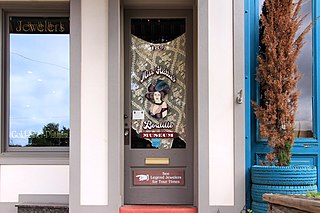
Miss Hattie's Bordello is a tourist trap and interpretive museum located in downtown San Angelo, Texas. It purports to be the building where "Miss Hattie" operated a brothel from 1902 to 1952.

