Mason County, Texas

Last updated

Mason County
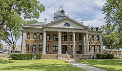
Mason County Courthouse August 2020.jpg
Map of Texas highlighting Mason County.svg
Location within the U.S. state of Texas
Texas in United States.svg
Texas's location within the U.S.
Coordinates: 30°43′N99°13′W / 30.72°N 99.22°W / 30.72; -99.22
CountryFlag of the United States.svg United States
StateFlag of Texas.svg  Texas
Founded1858
Named for Fort Mason
Seat Mason
Largest cityMason
Area
  Total932 sq mi (2,410 km2)
  Land929 sq mi (2,410 km2)
  Water3.4 sq mi (9 km2)  0.4%
Population
 (2020)
  Total3,953
  Density4.2/sq mi (1.6/km2)
Time zone UTC−6 (Central)
  Summer (DST) UTC−5 (CDT)
Congressional district 11th
Website www.co.mason.tx.us

Mason County is a rural county located on the Edwards Plateau in the U.S. state of Texas. At the 2020 census, its population was 3,953. [1] Its county seat is Mason. [2] The county is named for Fort Mason, which was located in the county.

Contents

History

February – County, spurred in part by anti-slavery sentiments of German residents, overwhelmingly votes against secession from the Union.
March – Fort Mason surrendered to the Confederacy, who leave it mostly vacant and thereby cause an uptick in Indian attacks on the area. [7] [8]
May 20 – Voters select town of Mason as County Seat. [9]
County’s first newspaper begins publication. [15]
Hoo Doo War over cattle rustling. [16]
Most famous participant in the war is Johnny Ringo, who on September 25, 1875, kills James Cheyney. [17] [18] [19]
Courthouse fire destroys all records. [11]

Geography

Ranchland in the Edwards Plateau, Mason County, Texas, USA (April 17, 2015). Ranchland in the Edwards Plateau, Mason County, Texas, USA (17 April 2015).jpg
Ranchland in the Edwards Plateau, Mason County, Texas, USA (April 17, 2015).

According to the U.S. Census Bureau, the county has a total area of 932 square miles (2,410 km2), of which 929 square miles (2,410 km2) is land and 3.4 square miles (8.8 km2) (0.4%) is water. [23]

Major highways

Adjacent counties

Demographics

Historical population
CensusPop.Note
1860 630
1870 6787.6%
1880 2,655291.6%
1890 5,18095.1%
1900 5,5737.6%
1910 5,6832.0%
1920 4,824−15.1%
1930 5,51114.2%
1940 5,378−2.4%
1950 4,945−8.1%
1960 3,780−23.6%
1970 3,356−11.2%
1980 3,6839.7%
1990 3,423−7.1%
2000 3,7389.2%
2010 4,0127.3%
2020 3,953−1.5%
U.S. Decennial Census [24]
1850–2010 [25] 2010 [26] 2020 [27]
Mason County, Texas - Demographic Profile
(NH = Non-Hispanic)
Race / EthnicityPop 2010 [26] Pop 2020 [27] % 2010% 2020
White alone (NH)3,0922,94877.07%74.58%
Black or African American alone (NH)1440.35%0.10%
Native American or Alaska Native alone (NH)1100.27%0.00%
Asian alone (NH)720.17%0.05%
Pacific Islander alone (NH)000.00%0.00%
Some Other Race alone (NH)4160.10%0.40%
Mixed Race/Multi-Racial (NH)201000.50%2.53%
Hispanic or Latino (any race)86488321.54%22.34%
Total4,0123,953100.00%100.00%

Note: the US Census treats Hispanic/Latino as an ethnic category. This table excludes Latinos from the racial categories and assigns them to a separate category. Hispanics/Latinos can be of any race.

At the 2000 census, [28] there were 3,738 people, 1,607 households and 1,110 families residing in the county. The population density was 4 people per square mile (1.5 people/km2). There were 2,372 housing units at an average density of 2 units per square mile (0.77/km2). The racial makeup of the county was 91.60% White, 0.13% Black or African American, 0.62% Native American, 0.05% Asian, 0.03% Pacific Islander, 5.75% from other races, and 1.82% from two or more races. 20.95% of the population were Hispanic or Latino of any race.

There were 1,607 households, of which 25.90% had children under the age of 18 living with them, 59.10% were married couples living together, 7.70% had a female householder with no husband present, and 30.90% were non-families. 29.20% of all households were made up of individuals, and 17.90% had someone living alone who was 65 years of age or older. The average household size was 2.31 and the average family size was 2.83.

22.40% of the population were under the age of 18, 4.70% from 18 to 24, 20.70% from 25 to 44, 28.80% from 45 to 64, and 23.50% who were 65 years of age or older. The median age was 47 years. For every 100 females there were 92.40 males. For every 100 females age 18 and over, there were 87.60 males.

The median household income was $30,921 and the median family income was $39,360. Males had a median income of $28,125 compared with $20,000 for females. The per capita income was $20,931. About 10.10% of families and 13.20% of the population were below the poverty line, including 20.50% of those under age 18 and 13.30% of those age 65 or over.

Communities

City

Unincorporated communities

Notable people

Politics

United States presidential election results for Mason County, Texas [29]
Year Republican Democratic Third party
No.%No.%No.%
2020 1,99180.48%45718.47%261.05%
2016 1,65680.51%35417.21%472.28%
2012 1,56579.52%38019.31%231.17%
2008 1,54472.80%54625.74%311.46%
2004 1,60077.03%45922.10%180.87%
2000 1,35275.07%41723.15%321.78%
1996 94954.70%61835.62%1689.68%
1992 77645.06%57033.10%37621.84%
1988 97558.91%67140.54%90.54%
1984 1,16867.01%57032.70%50.29%
1980 96659.59%63038.86%251.54%
1976 80549.09%81449.63%211.28%
1972 1,09673.71%36924.82%221.48%
1968 78951.98%56036.89%16911.13%
1964 59038.44%94161.30%40.26%
1960 83358.79%57540.58%90.64%
1956 88563.67%50436.26%10.07%
1952 1,06963.71%60636.11%30.18%
1948 49836.73%83661.65%221.62%
1944 42028.07%82254.95%25416.98%
1940 63437.25%1,06562.57%30.18%
1936 35931.30%78768.61%10.09%
1932 30927.08%82872.57%40.35%
1928 80776.64%24423.17%20.19%
1924 17123.82%38453.48%16322.70%
1920 26939.97%30445.17%10014.86%
1916 15727.30%38667.13%325.57%
1912 15217.21%47253.45%25929.33%

See also

Related Research Articles

<span class="mw-page-title-main">Wilson County, Texas</span> County in Texas, United States

Wilson County is a county located in the U.S. state of Texas. As of the 2020 census, its population was 49,753. Its county seat is Floresville. The county is named after James Charles Wilson. Wilson County is part of the San Antonio–New Braunfels, Texas, metropolitan statistical area.

<span class="mw-page-title-main">San Saba County, Texas</span> County in Texas, United States

San Saba County is a county located on the Edwards Plateau in western Central Texas, United States. As of the 2020 census, its population was 5,730. Its county seat is San Saba. The county is named after the San Saba River, which flows through the county.

<span class="mw-page-title-main">Reagan County, Texas</span> County in Texas, United States

Reagan County is a county on the Edwards Plateau in the U.S. state of Texas. As of the 2020 census, its population was 3,385. The county seat is Big Lake. The county is named after John Henninger Reagan (1818–1905), who was the postmaster general of the Confederate States and also a U.S. senator, U.S. representative, and first chairman of the Railroad Commission of Texas.

<span class="mw-page-title-main">Pecos County, Texas</span> County in Texas, United States

Pecos County is a county located in the U.S. state of Texas. As of the 2020 census, its population was 15,193. The county seat is Fort Stockton. The county was created in 1871 and organized in 1875. It is named for the Pecos River. It is one of the nine counties that comprise the Trans-Pecos region of West Texas.

<span class="mw-page-title-main">Menard County, Texas</span> County in Texas, United States

Menard County is a county located on the Edwards Plateau in the U.S. state of Texas. As of the 2020 census, its population was 1,962. The county seat is Menard. The county was created in 1858 and later organized in 1871. It is named for Michel Branamour Menard, the founder of Galveston, Texas.

<span class="mw-page-title-main">McCulloch County, Texas</span> County in Texas, United States

McCulloch County is a county located on the Edwards Plateau in the U.S. state of Texas. At the 2020 census, its population was 7,630. Its county seat is Brady. The county was created in 1856 and later organized in 1876. It is named for Benjamin McCulloch, a famous Texas Ranger and Confederate general.

<span class="mw-page-title-main">Llano County, Texas</span> County in Texas, United States

Llano County is a county located on the Edwards Plateau in the U.S. state of Texas. As of the 2020 census, its population was 21,243. Its county seat is Llano, and the county is named for the Llano River.

<span class="mw-page-title-main">Limestone County, Texas</span> County in the United States

Limestone County is a county in the U.S. state of Texas. As of the 2020 census, its population was 22,146. Its county seat is Groesbeck. The county was created in 1846.

<span class="mw-page-title-main">Kendall County, Texas</span> County in Texas, United States

Kendall County is a county located on the Edwards Plateau in the U.S. state of Texas. In 2020 census, its population was 44,279. Its county seat is Boerne. The county is named for George Wilkins Kendall, a journalist and Mexican–American War correspondent.

<span class="mw-page-title-main">Gillespie County, Texas</span> County in Texas, U.S.

Gillespie County is a county located on the Edwards Plateau in the U.S. state of Texas. As of the 2020 census, its population was 26,725. The county seat is Fredericksburg. It is located in the heart of the rural Texas Hill Country in Central Texas. Gillespie is named for Robert Addison Gillespie, a soldier in the Mexican–American War.

<span class="mw-page-title-main">Falls County, Texas</span> County in Texas, United States

Falls County is a county in the U.S. state of Texas. As of the 2020 census, its population was 16,968. The county seat is Marlin. It is named for the original 10-foot-tall waterfall on the Brazos River, which existed until the river changed course during a storm in 1866. The present falls is two miles northeast of the original falls, at the Falls on the Brazos Park, a camping site only a few miles out of Marlin on Farm to Market Road 712.

<span class="mw-page-title-main">Edwards County, Texas</span> County in Texas, United States

Edwards County is a county located on the Edwards Plateau in the U.S. state of Texas. As of the 2020 census its population was 1,422. The county seat is Rocksprings. The county was created in 1858 and organized in 1883. It is named for Haden Edwards, an early settler of Nacogdoches, Texas. The Edwards Aquifer and Edwards Plateau are named after the county by reason of their locations.

<span class="mw-page-title-main">Crockett County, Texas</span> County in Texas, United States

Crockett County is a county located on the Edwards Plateau in the U.S. state of Texas. As of the 2020 census, its population was 3,098. The county seat is Ozona. The county was founded in 1875 and later organized in 1891. It is named in honor of Davy Crockett, the legendary frontiersman who died at the Battle of the Alamo.

<span class="mw-page-title-main">Concho County, Texas</span> County in Texas, United States

Concho County is a county located on the Edwards Plateau in the U.S. state of Texas. At the 2020 census, the population was 3,303. Its county seat is Paint Rock. The county was founded in 1858 and later organized in 1879. It is named for the Concho River.

<span class="mw-page-title-main">Comanche County, Texas</span> County in Texas, United States

Comanche County is a county located on the Edwards Plateau in Central Texas. As of the 2020 census, its population was 13,594. The county seat is Comanche. The county was founded in 1856 and is named for the Comanche Native American tribe.

<span class="mw-page-title-main">Brown County, Texas</span> County in Texas, United States

Brown County is a county in west-central Texas. As of the 2020 census, the population was 38,095. Its county seat is Brownwood. The county was founded in 1856 and organized in 1858. It is named for Henry Stevenson Brown, a commander at the Battle of Velasco, an early conflict between Texians and Mexicans.

<span class="mw-page-title-main">Blanco County, Texas</span> County in Texas, United States

Blanco County is a United States county located in the U.S. state of Texas. It is located in Central Texas and its county seat is Johnson City.

<span class="mw-page-title-main">Mason, Texas</span> City in Texas, United States

Mason is a city in, and the county seat of, Mason County, Texas, United States. The city is an agricultural community on Comanche Creek southwest of Mason Mountain, on the Edwards Plateau and part of the Llano Uplift. Its population was 2,114 at the 2010 census.

<span class="mw-page-title-main">Runnels County, Texas</span> County in Texas, United States

Runnels County is a county located in the U.S. state of Texas. As of the 2020 census, its population was 9,900. Its county seat is Ballinger. The county was created in 1858 and later organized in 1880. It is named for Hiram G. Runnels, a Texas state legislator.

Loyal Valley is an unincorporated farming and ranching community, established in 1858, and is 6 miles (9.7 km) north of Cherry Spring in the southeastern corner of Mason County, in the U.S. state of Texas. The community is located near Cold Spring Creek, which runs east for 7.5 miles (12.1 km) to its mouth on Marschall Creek in Llano County, just east of Loyal Valley. The community is located on the old Pinta Trail.

References

  1. "Mason County, Texas". United States Census Bureau . Retrieved February 23, 2021.
  2. "Find a County". National Association of Counties. Retrieved June 7, 2011.
  3. 1 2 Rhoades, Alice J. "Mason County, Texas". Handbook of Texas Online. Texas State Historical Association. Retrieved November 27, 2010.
  4. "Comanche Indian Treaty". William Nienke, Sam Morrow. Archived from the original on July 18, 2011. Retrieved November 27, 2010.
  5. DeVos, Julius E. "Fort Mason, Texas". Handbook of Texas Online. Texas State Historical Association. Retrieved November 27, 2010.
  6. "Mason County – Mason vicinity". Texas State Historical Markers. William Nienke, Sam Morrow. Archived from the original on July 7, 2011. Retrieved November 27, 2010.
  7. "Texas Forts Trails". Texas Monthly: 72. June 1991.
  8. "Texas Escapes-Fort Mason, Texas". Texas Escapes – Blueprints For Travel, LLC. Retrieved November 27, 2010.
  9. Rhoades, Alice J. "Mason, Texas". Handbook of Texas Online. Texas State Historical Association. Retrieved November 27, 2010.
  10. "History Fort Mason (1851–1871)". Texas Forts of the Old West. Legends of America. Archived from the original on November 24, 2010. Retrieved November 27, 2010.
  11. 1 2 "Mason County Courthouse". Texas Escapes – Blueprints For Travel, LLC. Retrieved November 27, 2010.
  12. 1 2 Lehmann, Herman; Hunter, J Marvin; Giese, Dale F (1993). Nine Years Among the Indians, 1870–1879: The Story of the Captivity and Life of a Texan Among the Indians . University of New Mexico Press. ISBN   978-0-8263-1417-8.
  13. Hudspeth, Brewster. "The Savage Life Of Herman Lehmann". Texas Escapes – Blueprints For Travel, LLC. Retrieved November 27, 2010. Texas Escapes – Blueprints For Travel, LLC.
  14. Gould, Florence C; Pando, Patricia N. "Mason Co Tx Women Homesteaders". Tx Gen Web. Archived from the original on October 20, 2010. Retrieved November 27, 2010.
  15. "Gem of the Hill Country-Mason, Tex". Hill Country Portal. Retrieved November 27, 2010.
  16. Johnson, David; Miller, Rick (2009). The Mason County ""Hoo Doo"" War, 1874–1902 (A.C. Greene Series). University of North Texas Press. ISBN   978-1-57441-262-8.
  17. Johnson, David; Parsons, Chuck (2008). John Ringo, King of the Cowboys: His Life and Times from the Hoo Doo War to Tombstone, Second Edition (A. C. Greene). University of North Texas Press. ISBN   978-1-57441-243-7.
  18. Hadeler, Glenn. "The Mason County Hoo Doo Wars". TexFiles. Archived from the original on May 12, 2010. Retrieved April 30, 2010. TexFiles
  19. "Johnny Ringo and the Hoo Doo War" . Retrieved April 30, 2010.
  20. Garner, L Edwin. "Mineral Resources and Mining". Handbook of Texas Online. Texas State Historical Society. Retrieved November 27, 2010.
  21. Leatherwood, Art. "Hereford Cattle". Handbook of Texas Online. Texas State Historical Association. Retrieved November 27, 2010.
  22. Wentsch, George M. "Pedernales Electric Coop". Handbook of Texas Online. Texas State Historical Society. Retrieved November 27, 2010.
  23. "2010 Census Gazetteer Files". United States Census Bureau. August 22, 2012. Retrieved May 4, 2015.
  24. "Decennial Census of Population and Housing by Decade". US Census Bureau.
  25. "Texas Almanac: Population History of Counties from 1850–2010" (PDF). Texas Almanac. Archived (PDF) from the original on October 9, 2022. Retrieved May 4, 2015.
  26. 1 2 "P2 HISPANIC OR LATINO, AND NOT HISPANIC OR LATINO BY RACE - 2010: DEC Redistricting Data (PL 94-171) - Mason County, Texas". United States Census Bureau .
  27. 1 2 "P2 HISPANIC OR LATINO, AND NOT HISPANIC OR LATINO BY RACE - 2020: DEC Redistricting Data (PL 94-171) - Mason County, Texas". United States Census Bureau .
  28. "U.S. Census website". United States Census Bureau . Retrieved May 14, 2011.
  29. Leip, David. "Dave Leip's Atlas of U.S. Presidential Elections". uselectionatlas.org. Retrieved April 11, 2018.

30°43′N99°13′W / 30.72°N 99.22°W / 30.72; -99.22