Bee County, Texas

Last updated

Bee County
Bee courthouse.jpg
The Bee County Courthouse in Beeville was built in 1913.
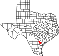
Map of Texas highlighting Bee County.svg
Location within the U.S. state of Texas
Texas in United States.svg
Texas's location within the U.S.
Coordinates: 28°25′N97°44′W / 28.42°N 97.74°W / 28.42; -97.74
CountryFlag of the United States.svg United States
StateFlag of Texas.svg  Texas
Founded1858
Named for Barnard E. Bee, Sr.
Seat Beeville
Largest cityBeeville
Area
  Total880 sq mi (2,300 km2)
  Land880 sq mi (2,300 km2)
  Water0.1 sq mi (0.3 km2)  0.01%
Population
 (2020)
  Total31,047
  Density35.3/sq mi (13.6/km2)
Time zone UTC−6 (Central)
  Summer (DST) UTC−5 (CDT)
Congressional district 27th
Website co.bee.tx.us

Bee County is a county located in the U.S. state of Texas. It is in South Texas and its county seat is Beeville. [1] As of the 2020 census, its population was 31,047. [2] The Beeville, TX micropolitan statistical area includes all of Bee County. The county was founded December 8, 1857, and organized the next year. [3] It is named for Barnard E. Bee, Sr., a secretary of state of the Republic of Texas.

Contents

History

On December 8, 1857, the Texas Legislature formed Bee County from sections of Refugio, Live Oak, San Patricio, Goliad, and Karnes Counties, naming it for Colonel Barnard Elliot Bee, who served the Republic of Texas as Sam Houston's secretary of war and Mirabeau B. Lamar's secretary of state. [4]

During the Anglo-American land speculation of the 1830s, the area's earliest settlers were mainly Irish immigrants, but by the late 1840s and early 1850s, the rise of Jacksonian expansionism inspired Southern whites from the North Carolina, South Carolina, Louisiana, and Mississippi to occupy and build settlements in the area. [5]

As the constitution of the Republic of Texas no longer recognized the Catholic Church (or any church) as the state religion and slave-holding settlers came to dominate the area in the 1840s, small Methodist, Presbyterian, and Baptist congregations began forming with sustained missionary support from these denominations. Research suggests that Baptists and Methodists comprised 65% of all Texas congregations by 1870. [6]

Geography

According to the U.S. Census Bureau, the county has a total area of 880 square miles (2,300 km2), of which 0.1 square miles (0.26 km2) (0.01%) is covered by water. [7] The Aransas River forms in Bee County, southwest of Beeville and north of Skidmore.

Major highways

Adjacent counties

Demographics

Historical population
CensusPop.Note
1860 910
1870 1,08218.9%
1880 2,298112.4%
1890 3,72061.9%
1900 7,720107.5%
1910 12,09056.6%
1920 12,1370.4%
1930 15,72129.5%
1940 16,4814.8%
1950 18,17410.3%
1960 23,75530.7%
1970 22,737−4.3%
1980 26,03014.5%
1990 25,135−3.4%
2000 32,35928.7%
2010 31,861−1.5%
2020 31,047−2.6%
U.S. Decennial Census [8]
1850–2010 [9] 2010–2020 [2]
Bee County racial/ethnic composition
(NH = Non-Hispanic) [lower-alpha 1]
RacePop 2010 [11] Pop 2020 [12] % 2010% 2020
White (NH)10,9678,60034.42%27.7%
Black or African American (NH)2,5252,3167.93%7.46%
Native American or Alaska Native (NH)70540.22%0.17%
Asian (NH)1622110.51%0.68%
Pacific Islander (NH)1020.03%0.01%
Some other race (NH)38650.12%0.21%
Mixed/multiracial (NH)1834070.57%1.31%
Hispanic or Latino 17,90619,39256.2%62.46%
Total31,86131,047

As of the 2020 United States census, 31,047 people, 8,499 households, and 5,693 families resided in the county. As of the 2010 United States census, 31,861 people were living in the county; 78.8% were White, 8.1% Black or African American, 0.6% Asian, 0.5% Native American, 0.1% Pacific Islander, 9.7% of some other race, and 2.3% of two or more races. About 56.2% were Hispanics or Latinos (of any race).

As of the Census [13] of 2000, 32,359 people, 9,061 households, and 6,578 families lived in the county. The population density was 37 people per square mile (14 people/km2). The 10,939 housing units had an average density of 12 units per square mile (4.6/km2). The racial makeup of the county was 67.85% White, 9.90% African American, 0.42% Native American, 0.51% Asian, 0.03% Pacific Islander, 19.15% from other races, and 2.13% from two or more races. About 53.93% of the population were Hispanics or Latinos of any race.

Of the 9,061 households, 37.8% had children under 18 living with them, 52.9% were married couples living together, 14.8% had a female householder with no husband present, and 27.4% were not families. About 23.7% of all households were made up of individuals, and 9.9% had someone living alone who was 65 or older. The average household size was 2.74, and the average family size was 3.25.

In the county, the population was distributed as 23.4% under 18, 13.3% from 18 to 24, 35.4% from 25 to 44, 17.8% from 45 to 64, and 10.2% who were 65 or older. The median age was 32 years. For every 100 females, there were 148.40 males. For every 100 females 18 and over, there were 164.90 males.

The median income for a household in the county was $28,392, and for a family was $32,967. Males had a median income of $26,473 versus $20,666 for females. The per capita income for the county was $10,625. About 19.70% of families and 24.00% of the population were below the poverty line, including 33.80% of those under age 18 and 18.30% of those age 65 or over.

Government and infrastructure

The Texas Department of Criminal Justice operates the Correctional Institutions Division Region IV Office on the grounds of Chase Field Naval Air Station in unincorporated Bee County. [14] In addition, Garza East Unit and Garza West Unit, transfer facilities, are co-located on the grounds of the naval air station, [15] [16] and the McConnell Unit is also in an unincorporated area in Bee County. [17] The Beeville Distribution Center is on the grounds of the air station. [18]

In 1981 the county government provided firefighting services in unincorporated areas, and there was a proposal to move that competency to four rural firefighting districts made largely on school district boundaries, each with taxing powers. [19]

Politics

Bee County is somewhat moderate in comparison to surrounding counties in its support of Republicans in presidential elections. In 2016, Donald Trump won less than 56% of the vote. As recently as 1996, it gave a majority of its votes to the Democratic candidate.

United States presidential election results for Bee County, Texas [20]
Year Republican Democratic Third party
No.%No.%No.%
2020 6,00663.72%3,28834.88%1321.40%
2016 4,74455.91%3,44440.59%2973.50%
2012 4,35655.29%3,45243.81%710.90%
2008 4,47154.81%3,64544.69%410.50%
2004 5,42857.03%4,04542.50%450.47%
2000 4,42953.17%3,79545.56%1061.27%
1996 3,61141.19%4,56152.03%5946.78%
1992 3,63339.89%4,08344.83%1,39215.28%
1988 4,62049.78%4,61649.74%450.48%
1984 5,37759.32%3,65940.37%280.31%
1980 4,17152.59%3,60645.47%1541.94%
1976 2,95343.93%3,69054.89%791.18%
1972 3,77964.42%2,06735.24%200.34%
1968 1,99535.98%2,95753.34%59210.68%
1964 1,50931.23%3,31468.58%90.19%
1960 2,22046.38%2,55753.42%100.21%
1956 2,40155.26%1,92944.40%150.35%
1952 2,53661.46%1,58338.37%70.17%
1948 80133.74%1,44160.70%1325.56%
1944 84835.17%1,30654.17%25710.66%
1940 94835.02%1,75964.98%00.00%
1936 60328.96%1,46270.22%170.82%
1932 53419.60%2,18080.03%100.37%
1928 1,18953.18%1,04346.65%40.18%
1924 94445.45%98747.52%1467.03%
1920 28330.66%54559.05%9510.29%
1916 15219.82%58476.14%314.04%
1912 355.91%47680.41%8113.68%

Education

The Joe Barnhart Bee County Library is located in downtown Beeville across the street from the courthouse. Bee County Library in Beeville, TX IMG 0982.JPG
The Joe Barnhart Bee County Library is located in downtown Beeville across the street from the courthouse.

These school districts serve Bee County: [21]

Coastal Bend College (formerly Bee County College), a postsecondary institution, serves Bee County among other counties and areas. [22]

Communities

The Bee County Courthouse in Beeville was designed by architect W.C. Stephenson, formerly of Buffalo, New York Bee County Courthouse in Beeville, TX IMG 0981.JPG
The Bee County Courthouse in Beeville was designed by architect W.C. Stephenson, formerly of Buffalo, New York

City

Census-designated places

Unincorporated communities

See also

Related Research Articles

<span class="mw-page-title-main">Walker County, Texas</span> County in Texas, United States

Walker County is a county located in the east central section of the U.S. state of Texas. As of the 2020 census, its population was 76,400. Its county seat is Huntsville. Initially, Walker County was named for Robert J. Walker, a legislator from Mississippi who introduced into the United States Congress the resolution to annex Texas. Walker later supported the U.S. during its Civil War and earned some enmity for it. In order to keep the county's name, the state renamed it for Samuel H. Walker, a Texas Ranger and soldier in the United States Army.

<span class="mw-page-title-main">Trinity County, Texas</span> County in Texas, United States

Trinity County is a county located in the U.S. state of Texas. As of the 2020 census, the population was 13,602. Its county seat is Groveton. The county is named for the Trinity River.

<span class="mw-page-title-main">Starr County, Texas</span> County in Texas, United States

Starr County is located in the U.S. state of Texas. As of the 2020 census, its population was 65,920. Its county seat is Rio Grande City. The county was created in 1848. It is named for James Harper Starr, who served as secretary of the treasury of the Republic of Texas.

<span class="mw-page-title-main">Potter County, Texas</span> County in Texas, United States

Potter County is a county located in the U.S. state of Texas. As of the 2020 census, its population was 118,525. Its county seat is Amarillo. The county was created in 1876 and organized in 1887. It is named for Robert Potter, a politician, signer of the Texas Declaration of Independence, and the Texas Secretary of the Navy. Potter County is included in the Amarillo metropolitan area.

<span class="mw-page-title-main">Polk County, Texas</span> County in Texas, United States

Polk County is a county located in the U.S. state of Texas. As of the 2020 census, its population was 50,123. Its county seat is Livingston. The county is named after James K. Polk.

<span class="mw-page-title-main">McMullen County, Texas</span> County in Texas, United States

McMullen County is a county located in the U.S. state of Texas. As of the 2020 census, its population was 600, making it the fourth-least populous county in Texas. Its county seat is Tilden. The county was established from parts of Bexar County, Atascosa County, and Live Oak County in 1858 and later organized in 1877. It is named for John McMullen, founder of a colony in Texas. The McMullen County Courthouse was designed by the architect W.C. Stephenson, originally from Buffalo, New York. Stephenson also designed some 50 buildings in Beeville, including the Bee County Courthouse.

<span class="mw-page-title-main">Madison County, Texas</span> County in Texas, United States

Madison County is a county located in the U.S. state of Texas. As of the 2020 census, its population was 13,455. Its seat is Madisonville. The county was created in 1853 and organized the next year. It is named for James Madison, the fourth President of the United States. In 1852, Hillary Mercer Crabb was elected to serve the unexpired term of State Representative F. L. Hatch. Among Crabb's accomplishments as a legislator was the introduction of a bill to create Madison County.

<span class="mw-page-title-main">Lynn County, Texas</span> County in Texas, United States

Lynn County is a county in the U.S. state of Texas. As of the 2020 census, its population was 5,596. Its county seat is Tahoka. The county was created in 1876 and organized in 1903.

<span class="mw-page-title-main">Live Oak County, Texas</span> County in Texas, United States

Live Oak County is a county in the U.S. state of Texas. It was named for its native groves of live oak. George West is its county seat. Its population was 11,335 in the 2020 census.

<span class="mw-page-title-main">Lamb County, Texas</span> County in Texas, United States

Lamb County is a county located in the U.S. state of Texas. As of the 2020 census, its population was 13,045. Its county seat is Littlefield. The county was created in 1876, but not organized until 1908. It is named for George A. Lamb, who died in the Battle of San Jacinto.

<span class="mw-page-title-main">Houston County, Texas</span> County in Texas, United States

Houston County is a county located in the U.S. state of Texas. As of the 2020 census, its population was 22,066. Its county seat is Crockett. Houston County was one of 46 entirely dry counties in the state of Texas, until voters in a November 2007 special election legalized the sale of alcohol in the county.

<span class="mw-page-title-main">Grimes County, Texas</span> Country in Texas, United States

Grimes County is a county located in southeastern Texas, United States. As of the 2020 census, its population was 29,268. The seat of the county is Anderson. The county was formed from Montgomery County in 1846. It is named for Jesse Grimes, a signer of the Texas Declaration of Independence and early European-American settler of the county.

<span class="mw-page-title-main">Garza County, Texas</span> County in Texas, United States

Garza County is a county located in the U.S. state of Texas. As of the 2020 census, its population was 5,816, of which most of the population were residing in its county seat, and only incorporated municipality, Post. The county was created in 1876 and later organized in 1907. Garza is named for a pioneer Bexar County family, as it was once a part of that county.

<span class="mw-page-title-main">Atascosa County, Texas</span> County in Texas, United States

Atascosa County is a county located in the U.S. state of Texas. It is in South Texas and its county seat is Jourdanton.

<span class="mw-page-title-main">Aransas County, Texas</span> County in Texas, United States

Aransas County is a county located in the U.S. state of Texas. It is in South Texas and its county seat is Rockport.

<span class="mw-page-title-main">Beeville, Texas</span> City in Texas, United States

Beeville is a city in Bee County, Texas, United States. Its population of 13,543 at the 2020 census makes it the 207th-largest city in Texas. It is the county seat of Bee County and home to the main campus of Coastal Bend College. The area around the city contains three prisons operated by the Texas Department of Criminal Justice.

<span class="mw-page-title-main">Blue Berry Hill, Texas</span> Census-designated place in Texas, United States

Blueberry Hill is a census-designated place (CDP) in Bee County, Texas, United States. The population was 866 at the 2010 census. It is located just outside Beeville and has no services of its own. Drinking water and garbage services are provided by the city of Beeville. Mailing addresses for Blueberry Hill are labeled "Beeville".

<span class="mw-page-title-main">Skidmore, Texas</span> Census-designated place in Texas, United States

Skidmore is a census-designated place (CDP) in Bee County, Texas, United States. The population was 925 at the 2010 census.

Garza East Unit was a correctional transfer unit on the grounds of Chase Field Industrial Complex in unincorporated Bee County, Texas, near Beeville. It was co-located with the Garza West Unit. The facility closed in 2020.

Garza West Unit is a correctional transfer unit on the grounds of Chase Field Industrial Complex in unincorporated Bee County, Texas, near the city of Beeville. It is co-located with the Garza East Unit.

References

  1. "Find a County". National Association of Counties. Archived from the original on July 12, 2012. Retrieved June 7, 2011.
  2. 1 2 "U.S. Census Bureau QuickFacts: Bee County, Texas". United States Census Bureau. Retrieved January 31, 2022.
  3. "Texas: Individual County Chronologies". Texas Atlas of Historical County Boundaries. The Newberry Library. 2008. Archived from the original on May 13, 2015. Retrieved May 20, 2015.
  4. Ezell, Camp (1973). The Historical Story of Bee County, Texas. Beeville, Texas: Beeville Publishing Co. p. 25.
  5. Jordan, Terry G. (January 1969). "The Origin of Anglo-American Cattle Ranching in Texas: A Documentation of Diffusion from the Lower South". Economic Geography. 45 (45): 63–87. doi:10.2307/143180. JSTOR   143180.
  6. Pritchard, Linda K. (1988). "A Comparative Approach to Western Religious History: Texas as a Case Study, 1845-1890". The Western Historical Quarterly. 19 (4): 413–430. doi:10.2307/968321. JSTOR   968321.
  7. "2010 Census Gazetteer Files". United States Census Bureau. August 22, 2012. Retrieved April 19, 2015.
  8. "Decennial Census of Population and Housing by Decades". US Census Bureau.
  9. "Texas Almanac: Population History of Counties from 1850–2010" (PDF). Texas Almanac. Archived (PDF) from the original on October 9, 2022. Retrieved April 19, 2015.
  10. "About the Hispanic Population and its Origin". www.census.gov. Retrieved May 18, 2022.
  11. "Explore Census Data". data.census.gov. Retrieved May 21, 2022.
  12. "Explore Census Data". data.census.gov. Retrieved May 21, 2022.
  13. "U.S. Census website". United States Census Bureau . Retrieved May 14, 2011.
  14. "Correctional Institutions Division Region IV Director's Office Archived 2008-01-21 at the Wayback Machine ." Texas Department of Criminal Justice. Retrieved on May 21, 2010.
  15. "Garza East Unit Archived 2008-01-18 at the Wayback Machine ." Texas Department of Criminal Justice. Retrieved on May 21, 2010.
  16. "Garza West Unit Archived 2010-07-25 at the Wayback Machine ." Texas Department of Criminal Justice. Retrieved on May 21, 2010.
  17. "McConnell Unit Archived 2010-07-25 at the Wayback Machine ." Texas Department of Criminal Justice. Retrieved on May 21, 2010.
  18. "Beeville Distribution Center Archived 2010-07-12 at the Wayback Machine ." Texas Department of Criminal Justice. Retrieved on May 22, 2010.
  19. "Fire Districts Reviews". Victoria Advocate . Victoria, Texas. January 31, 1981. p. 2D. - Clipping at Newspapers.com.
  20. Leip, David. "Dave Leip's Atlas of U.S. Presidential Elections". uselectionatlas.org. Retrieved July 19, 2018.
  21. "2020 CENSUS - SCHOOL DISTRICT REFERENCE MAP: Bee County, TX" (PDF). U.S. Census Bureau . Retrieved February 15, 2024. - Text list
  22. Texas Education Code Sec. 130.167. BEE COUNTY COLLEGE DISTRICT SERVICE AREA. The legislation calls it "Bee County College".
  1. Note: the US Census treats Hispanic/Latino as an ethnic category. This table excludes Latinos from the racial categories and assigns them to a separate category. Hispanics/Latinos can be of any race. [10]

28°25′N97°44′W / 28.42°N 97.74°W / 28.42; -97.74