Brewster County, Texas

Last updated

Brewster County
Brewster County Courthouse June 2020.jpg
The Brewster County Courthouse in Alpine
Map of Texas highlighting Brewster County.svg
Location within the U.S. state of Texas
Texas in United States.svg
Texas's location within the U.S.
Coordinates: 29°48′43″N103°15′06″W / 29.81185°N 103.2517°W / 29.81185; -103.2517
CountryFlag of the United States.svg United States
StateFlag of Texas.svg  Texas
Founded1887
Named for Henry Percy Brewster
Seat Alpine
Largest cityAlpine
Area
  Total6,192 sq mi (16,040 km2)
  Land6,184 sq mi (16,020 km2)
  Water8.5 sq mi (22 km2)  0.1%
Population
 (2020)
  Total9,546
  Density1.5/sq mi (0.6/km2)
Time zone UTC−6 (Central)
  Summer (DST) UTC−5 (CDT)
Congressional district 23rd
Website www.brewstercountytx.com

Brewster County is a county located in the U.S. state of Texas. It is in West Texas and its county seat (and only city) is Alpine. [1] It is one of the nine counties that comprise the Trans-Pecos region, and borders Mexico. Brewster County is the largest county by area in the state - at 6,192 square miles (16,040 km2) it is over three times the size of the state of Delaware, and more than 500 square miles (1,300 km2) bigger than Connecticut. [2]

Contents

As of the 2020 census, the population was 9,546. [3]

The county is named for Colonel Henry Percy Brewster, a Secretary of War for the Republic of Texas.

History

Native Americans

Paleo-Indian hunter-gatherers existed in the region at least 9000 years ago. Mescalaro Apaches emerged later and conducted raids that discouraged settlers. Between 1779 and 1787, Col. Juan de Ugalde drove the Mescalaros back north across the Rio Grande and into the Chisos Mountains. The three leading Mescalero chiefs, Patula Grande, Quemado, and Zapato Tuerto, agreed in March 1789 to submit to Spanish rule. [4] Comanche raiding parties continued through much of the 19th century. [5]

Early explorations

Chihuahuan Desert landscape in Brewster County FouquieriaSplendens 2006 BigBend.jpg
Chihuahuan Desert landscape in Brewster County

Spanish explorers Álvar Núñez Cabeza de Vaca in 1535 and Antonio de Espejo in 1583 crossed Brewster County on their way to La Junta de los Ríos, the junction of the Rio Grande and the Rio Conchos. [6]

In 1684, Juan Domínguez de Mendoza camped at Kokernot Spring and wrote the earliest recorded description of it. [7]

Pedro de Rábago y Terán, Governor of Coahuila in the 1740s, led an expedition to La Junta de los Ríos. [8]

Northern Mexican military governor Lt. Col. Hugo Oconór led a 1772 expedition to locate sites for forts on the Comanche Trail along the Rio Grande. [9] [10]

In October 1851, Danish-born Col. Edvard Emil Langberg, Mexican commandant of Chihuahua, visited southern Brewster County. [11]

Surveyor William H. Emory in 1852 sent M. T. W. Chandler to survey what is now the heart of Big Bend National Park. Chandler explored Santa Elena Canyon, the Chisos Mountains Mariscal Canyon, and Boquillas Canyon. [12]

An 1859 expedition of the U.S. Camel Corps under 2d Lt. Edward L. Hartz explored the Comanche Trail through Persimmon Gap and down Tornillo Creek to the Rio Grande. A year later, a second camel expedition under 2d Lt. William Echols also explored along the Rio Grande. [5]

County established and growth

Map of Presidio County, Texas and the counties of Brewster, Buchel, Foley, and Jeff Davis created from Presidio in 1887: Buchel and Foley were abolished and joined to Brewster in 1897. PresidioAndNewCounties1888.jpg
Map of Presidio County, Texas and the counties of Brewster, Buchel, Foley, and Jeff Davis created from Presidio in 1887: Buchel and Foley were abolished and joined to Brewster in 1897.

Brewster County was marked off in 1887 from Presidio County and named for Henry Percy Brewster. Murphyville, later renamed Alpine, was selected as county seat. [13]

In response to threats of ongoing Indian attacks, Camp Peña Colorado was established in 1879 a few miles south of the future site of Marathon. [14]

Word of mouth about the open rangeland in the area was spread by freighters John W Burgess and August Santleben, leading the way for settlers. [15]

The Galveston, Harrisburg and San Antonio Railway built through the area in 1882, opening up opportunity for entrepreneurs who came on railroad-related business and stayed. [16]

Alfred S. Gage moved to the area in 1882 to help his brother's ranching operation, founding the A. S. Gage Ranch, one of the largest ranching operations in Texas, in 1883. In 1927, he built the Gage Hotel in Marathon. [17] [18] [19]

Legendary lawman and later Texas Rangers Hall of Fame member James B. Gillett served as sheriff of Brewster County, and operated a ranch in Alpine in the late 19th and early 20th centuries. He later retired to his Barrel Spring Ranch in Jeff Davis County. [20] [21] [22]

Joseph Daniel Jackson came to the area in 1882 as part of Company B of the Texas Rangers assigned to protect the railroad. By 1882, he had settled near Alpine and taken up ranching, branching out later to become a merchant and civic leader. Jackson is known locally as the father of Sul Ross University due to his efforts that helped lead to the establishment of the school. [23] Sul Ross University, named for Texas Governor Lawrence Sullivan Ross, was created by an act of the 35th Legislature in 1917 as a state normal college to train teachers. [24]

Population boom

The population grew from 710 in 1890 to 5,220 in 1910 due for the most part to industries that relied on natural resources. [5]

From the turn of the 20th century through World War II, the Terlingua Mining District, west of the Chisos Mountains, was a boom town due to the extraction of cinnabar, a mercury ore. Silver and lead from mines on the Mexican side of the river in the Boquillas area were shipped north, as were candelilla wax produced at factories at Glenn Spring and Mariscal, and the guayule rubber from a factory in Marathon. [25]

Pancho Villa and banditos

Brewster County became targeted by incursions of bandits from Mexico, inspired at least in part by Pancho Villa. In June 1915, Governor James E. Ferguson asked President Woodrow Wilson to station troops in the Big Bend. The request was denied by Maj. Gen. Frederick Funston, who believed such security was a state issue. Although a number of events took place to effect policy change, the tipping point was the May 5, 1916 raid at Glenn Spring. Only nine soldiers had been stationed in the area for protection against the bandits. Estimates vary as to the number of Mexican raiders who attacked the soldiers, from 60 to several hundred. The raid caused a larger military presence in the area. President Wilson mobilized the National Guard to reinforce the Army, and by the end of 1916, an estimated 116,957 guardsmen were stationed along the border from California to Texas. As the mines and wax factories played out after World War I, raids from across the border abated. [26]

Big Bend

The geographic region known as the Big Bend is a loosely defined section of the Trans-Pecos, although generally agreed to comprise its more southern portions. Characterized by an extremely rugged, arid Chihuahuan Desert landscape, the region takes its name from the sharp northeastward turn made by the Rio Grande nearby. Often noted for its stark beauty, the Big Bend was described by the historian Walter Prescott Webb as "the finest example of earth-wreckage in Texas". [27] It was for this reason that a national park was to be established in the region.

Big Bend National Park was established as a state park in 1933 by the state legislature, and expanded the same year by Governor Miriam A. Ferguson. In 1935, the United States Congress passed legislation founding it as a national park. Big Bend opened to the public in 1944. [28] At just over 800,000 acres, it is the fourteenth largest national park in the United States and is larger than the state of Rhode Island. [29]

Big Bend Ranch State Park (located partially in Presidio County) opened to the public in 1991; at 300,000 acres (1,200 km2), it is the largest state park in Texas. [30]

Terlingua Chili Cookoffs

Terlingua produced 40% of the nation's quicksilver in 1920, but declining population has since qualified it as a ghost town. In 1962, The Dallas Morning News columnist Francis X. Tolbert published his ode to chili Bowl of Red and founded the Chili Appreciation Society. Fellow columnist Wick Fowler joined in the fun and became a charter member. The World Championship Chili Cookoff at Terlingua began as a tongue-in-cheek challenge between Fowler and humorist H. Allen Smith in 1967 and has become a November tradition, celebrated across the state and nation. On the first Saturday in November Terlingua now hosts two competing international chili championships: the Terlingua International Chili Championship, and the Original Terlingua International Chili Cookoff. [31]

Geography

According to the U.S. Census Bureau, the county has a total area of 6,192 square miles (16,040 km2), of which 6,184 square miles (16,020 km2) are land and 8.5 square miles (22 km2) (0.1%) are covered by water. [32] It is the largest county in Texas by area. The only substantial water is half the width of the Rio Grande.

The county's area is larger than the combined area of Delaware and Rhode Island, and larger than area of the individual states Connecticut, Delaware, and Rhode Island.

The Roadian Age of the Permian Period of geological time is named for rock strata in Road Canyon in the northern part of the county. [33]

The Wordian Age of the Permian Period is probably named for the Word Ranch in the Glass Mountains, also in the northern part. [34]

Adjacent counties and municipalities

Sunset in Big Bend National Park Big Bend South Rim sunset.jpg
Sunset in Big Bend National Park

National protected areas

Major highways

U.S. Highway 90 crosses the county in the north; U.S. Highway 385 enters Brewster County from the northeast and proceeds south to the county's main attraction, Big Bend National Park, part of the Big Bend. The Sunset Route of the Union Pacific Railroad crosses northern parts of the county, and a recently revived portion of the Kansas City, Mexico and Orient Railway traverses the county en route to Presidio.

Climate

Map this section's coordinates using: OpenStreetMap

About 39.4% of Brewster County is classified as having a hot arid desert climate (Köppen BWh). The remainder has a semiarid steppe climate with 32.1% experiencing a cold steppe climate (Köppen BSk), while 28.5% is assigned as a hot steppe climate (Köppen BSh). [35] Temperatures are coolest and rainfall most abundant in the county's northern highlands and in the upper elevations of the Chisos Mountains in the south. In the southern lowlands along the Rio Grande, snowfall is uncommon, rainfall much reduced, and summer high temperatures can be extreme. Throughout the county, precipitation falls mostly from May through October with the remainder of the year predominantly dry.

Alpine
Climate data for Alpine, Texas (Mar 1, 1900–Mar 31, 2013)
MonthJanFebMarAprMayJunJulAugSepOctNovDecYear
Mean daily maximum °F (°C)60.5
(15.8)
64.5
(18.1)
70.9
(21.6)
78.7
(25.9)
85.4
(29.7)
90.8
(32.7)
89.4
(31.9)
88.5
(31.4)
83.8
(28.8)
77.8
(25.4)
67.8
(19.9)
61.5
(16.4)
76.6
(24.8)
Mean daily minimum °F (°C)32.7
(0.4)
35.2
(1.8)
40.1
(4.5)
47.5
(8.6)
55.5
(13.1)
62.7
(17.1)
64.0
(17.8)
63.1
(17.3)
58.0
(14.4)
49.5
(9.7)
39.3
(4.1)
33.9
(1.1)
48.5
(9.2)
Average precipitation inches (mm)0.53
(13)
0.48
(12)
0.36
(9.1)
0.50
(13)
1.24
(31)
2.30
(58)
2.75
(70)
2.65
(67)
2.57
(65)
1.30
(33)
0.51
(13)
0.60
(15)
15.79
(399.1)
Source: Western Regional Climate Center, Desert Research Institute [37]
Castolon
Climate data for Castolon, Texas (Feb 1, 1947–Mar 31, 2013)
MonthJanFebMarAprMayJunJulAugSepOctNovDecYear
Mean daily maximum °F (°C)68.3
(20.2)
74.4
(23.6)
82.9
(28.3)
91.9
(33.3)
99.8
(37.7)
103.4
(39.7)
102.2
(39.0)
101.1
(38.4)
96.3
(35.7)
88.5
(31.4)
77.7
(25.4)
68.4
(20.2)
87.9
(31.1)
Mean daily minimum °F (°C)34.5
(1.4)
39.5
(4.2)
47.1
(8.4)
56.2
(13.4)
66.2
(19.0)
73.1
(22.8)
74.4
(23.6)
73.5
(23.1)
68.6
(20.3)
57.7
(14.3)
44.2
(6.8)
35.4
(1.9)
55.9
(13.3)
Average precipitation inches (mm)0.37
(9.4)
0.29
(7.4)
0.23
(5.8)
0.41
(10)
0.96
(24)
1.45
(37)
1.71
(43)
1.62
(41)
1.47
(37)
1.06
(27)
0.36
(9.1)
0.30
(7.6)
10.23
(258.3)
Source: Western Regional Climate Center, Desert Research Institute [38]
Chisos Basin
Climate data for Chisos Basin, Texas (Aug 1, 1943–Mar 31, 2013)
MonthJanFebMarAprMayJunJulAugSepOctNovDecYear
Mean daily maximum °F (°C)58.3
(14.6)
61.8
(16.6)
68.7
(20.4)
76.3
(24.6)
82.8
(28.2)
86.8
(30.4)
84.8
(29.3)
83.7
(28.7)
79.5
(26.4)
73.8
(23.2)
65.2
(18.4)
59.4
(15.2)
73.4
(23.0)
Mean daily minimum °F (°C)36.9
(2.7)
39.1
(3.9)
44.1
(6.7)
51.5
(10.8)
58.5
(14.7)
63.3
(17.4)
63.7
(17.6)
62.7
(17.1)
58.6
(14.8)
51.9
(11.1)
43.2
(6.2)
37.9
(3.3)
50.9
(10.5)
Average precipitation inches (mm)0.68
(17)
0.58
(15)
0.41
(10)
0.62
(16)
1.59
(40)
2.21
(56)
3.39
(86)
3.12
(79)
2.48
(63)
1.51
(38)
0.57
(14)
0.51
(13)
17.67
(447)
Source: Western Regional Climate Center, Desert Research Institute [39]
Lajitas
Climate data for Lajitas, Texas (Mar 1, 1978–Mar 31, 2013)
MonthJanFebMarAprMayJunJulAugSepOctNovDecYear
Mean daily maximum °F (°C)68.8
(20.4)
75.0
(23.9)
83.1
(28.4)
91.2
(32.9)
97.8
(36.6)
102.2
(39.0)
100.5
(38.1)
99.1
(37.3)
95.1
(35.1)
87.8
(31.0)
77.4
(25.2)
69.2
(20.7)
87.3
(30.7)
Mean daily minimum °F (°C)34.6
(1.4)
39.1
(3.9)
45.8
(7.7)
54.3
(12.4)
63.8
(17.7)
73.0
(22.8)
74.1
(23.4)
72.9
(22.7)
67.6
(19.8)
56.3
(13.5)
43.6
(6.4)
35.2
(1.8)
55.0
(12.8)
Average precipitation inches (mm)0.33
(8.4)
0.27
(6.9)
0.23
(5.8)
0.34
(8.6)
0.95
(24)
1.47
(37)
2.16
(55)
1.32
(34)
1.57
(40)
1.29
(33)
0.30
(7.6)
0.24
(6.1)
10.47
(266.4)
Source: Western Regional Climate Center, Desert Research Institute [40]
Marathon
Climate data for Marathon, Texas (Jul 1, 1896–Feb 28, 2013)
MonthJanFebMarAprMayJunJulAugSepOctNovDecYear
Mean daily maximum °F (°C)62.1
(16.7)
65.7
(18.7)
72.9
(22.7)
80.3
(26.8)
86.5
(30.3)
91.1
(32.8)
90.5
(32.5)
90.0
(32.2)
84.9
(29.4)
78.6
(25.9)
69.3
(20.7)
63.0
(17.2)
77.9
(25.5)
Mean daily minimum °F (°C)28.8
(−1.8)
31.5
(−0.3)
37.2
(2.9)
44.6
(7.0)
53.1
(11.7)
60.0
(15.6)
62.4
(16.9)
61.3
(16.3)
56.5
(13.6)
46.4
(8.0)
35.5
(1.9)
29.8
(−1.2)
45.6
(7.6)
Average precipitation inches (mm)0.44
(11)
0.40
(10)
0.40
(10)
0.74
(19)
1.62
(41)
1.87
(47)
2.21
(56)
2.14
(54)
2.42
(61)
1.40
(36)
0.52
(13)
0.51
(13)
14.67
(371)
Source: Western Regional Climate Center, Desert Research Institute [41]
Panther Junction
Climate data for Panther Junction, Texas (Apr 1, 1955–Mar 31, 2013)
MonthJanFebMarAprMayJunJulAugSepOctNovDecYear
Mean daily maximum °F (°C)61.6
(16.4)
66.4
(19.1)
74.5
(23.6)
83.2
(28.4)
89.9
(32.2)
94.3
(34.6)
92.9
(33.8)
91.7
(33.2)
86.9
(30.5)
79.8
(26.6)
70.0
(21.1)
62.6
(17.0)
79.5
(26.4)
Mean daily minimum °F (°C)36.0
(2.2)
39.2
(4.0)
45.6
(7.6)
53.5
(11.9)
61.4
(16.3)
67.2
(19.6)
68.8
(20.4)
67.8
(19.9)
62.4
(16.9)
53.9
(12.2)
44.1
(6.7)
37.4
(3.0)
53.1
(11.7)
Average precipitation inches (mm)0.48
(12)
0.50
(13)
0.33
(8.4)
0.54
(14)
1.37
(35)
1.64
(42)
2.13
(54)
1.99
(51)
1.82
(46)
1.42
(36)
0.56
(14)
0.43
(11)
13.21
(336.4)
Source: Western Regional Climate Center, Desert Research Institute [42]
Persimmon Gap
Climate data for Persimmon Gap, Texas (May 2, 1952–Mar 31, 2013)
MonthJanFebMarAprMayJunJulAugSepOctNovDecYear
Mean daily maximum °F (°C)64.5
(18.1)
69.2
(20.7)
77.5
(25.3)
86.3
(30.2)
93.7
(34.3)
97.7
(36.5)
96.4
(35.8)
95.7
(35.4)
90.4
(32.4)
83.3
(28.5)
73.0
(22.8)
64.0
(17.8)
82.6
(28.2)
Mean daily minimum °F (°C)33.8
(1.0)
37.3
(2.9)
44.7
(7.1)
53.4
(11.9)
62.8
(17.1)
70.5
(21.4)
72.1
(22.3)
71.6
(22.0)
65.3
(18.5)
54.3
(12.4)
42.0
(5.6)
34.3
(1.3)
53.5
(12.0)
Average precipitation inches (mm)0.40
(10)
0.37
(9.4)
0.34
(8.6)
0.43
(11)
1.02
(26)
1.36
(35)
1.65
(42)
1.60
(41)
1.71
(43)
0.94
(24)
0.50
(13)
0.34
(8.6)
10.66
(271.6)
Source: Western Regional Climate Center, Desert Research Institute [43]
Study Butte
Climate data for Study Butte, Texas (May 1, 1993–Jun 30, 2006)
MonthJanFebMarAprMayJunJulAugSepOctNovDecYear
Mean daily maximum °F (°C)69.2
(20.7)
73.2
(22.9)
81.0
(27.2)
88.9
(31.6)
98.2
(36.8)
100.6
(38.1)
99.6
(37.6)
98.2
(36.8)
94.7
(34.8)
86.3
(30.2)
75.7
(24.3)
66.3
(19.1)
86.0
(30.0)
Mean daily minimum °F (°C)36.5
(2.5)
41.5
(5.3)
47.3
(8.5)
55.2
(12.9)
66.3
(19.1)
72.9
(22.7)
73.8
(23.2)
73.0
(22.8)
67.9
(19.9)
57.2
(14.0)
45.9
(7.7)
36.5
(2.5)
56.2
(13.4)
Average precipitation inches (mm)0.26
(6.6)
0.17
(4.3)
0.37
(9.4)
0.33
(8.4)
0.63
(16)
1.32
(34)
1.86
(47)
1.77
(45)
0.61
(15)
1.09
(28)
0.47
(12)
0.26
(6.6)
9.14
(232.3)
Source: Western Regional Climate Center, Desert Research Institute [44]
Terlingua Ranch
Climate data for Terlingua Ranch, Texas (May 1, 1993–Mar 31, 2013)
MonthJanFebMarAprMayJunJulAugSepOctNovDecYear
Mean daily maximum °F (°C)63.5
(17.5)
66.9
(19.4)
74.2
(23.4)
82.8
(28.2)
91.2
(32.9)
95.0
(35.0)
93.8
(34.3)
93.2
(34.0)
88.5
(31.4)
80.3
(26.8)
71.0
(21.7)
62.4
(16.9)
80.2
(26.8)
Mean daily minimum °F (°C)34.8
(1.6)
37.9
(3.3)
43.7
(6.5)
51.5
(10.8)
61.0
(16.1)
66.9
(19.4)
68.0
(20.0)
67.3
(19.6)
61.9
(16.6)
52.6
(11.4)
42.5
(5.8)
35.3
(1.8)
51.9
(11.1)
Average precipitation inches (mm)0.36
(9.1)
0.38
(9.7)
0.42
(11)
0.48
(12)
0.98
(25)
1.46
(37)
2.28
(58)
1.27
(32)
1.27
(32)
1.04
(26)
0.44
(11)
0.20
(5.1)
10.58
(267.9)
Source: Western Regional Climate Center, Desert Research Institute [45]

Demographics

Historical population
CensusPop.Note
1890 710
1900 2,356231.8%
1910 5,220121.6%
1920 4,822−7.6%
1930 6,62437.4%
1940 6,478−2.2%
1950 7,30912.8%
1960 6,434−12.0%
1970 7,78020.9%
1980 7,573−2.7%
1990 8,68114.6%
2000 8,8662.1%
2010 9,2324.1%
2020 9,5463.4%
U.S. Decennial Census [46]
1850–2010 [47] 2010–2020 [3]
Brewster County racial/ethnic composition [48] [49]
(NH = Non-Hispanic) [lower-alpha 1]
RacePop 2010Pop 2020% 2010% 2020
White (NH)5,0114,94854.28%51.83%
Black or African American (NH)791620.86%1.7%
Native American or Alaska Native (NH)38300.41%0.31%
Asian (NH)58940.63%0.98%
Pacific Islander (NH)5110.05%0.12%
Some Other Race (NH)11560.12%0.59%
Mixed/Multi-Racial (NH)1122821.21%2.95%
Hispanic or Latino 3,9183,96342.44%41.51%
Total9,2329,546

As of the 2020 United States census, there were 9,546 people, 4,292 households, and 2,300 families residing in the county. As of the 2015 Texas population estimate program, the population of the county was 9,152: non-Hispanic whites, 4,934 (53.9%); non-Hispanic blacks, 76 (0.8%); other non-Hispanics, 261 (2.9%); and Hispanics and Latinos (of any race), 3,881 (42.4%). [51] Per the prior 2010 United States census, 9,232 people resided in the county; 86.6% were White, 1.1% Black or African American, 1.1% Native American, 0.7% Asian, 0.1% Pacific Islander, 7.6% of some other race and 2.8% of two or more races. About 42.4% were Hispanic or Latino (of any race).

Education

Map of Brewster County, Texas with school district boundaries Brewster Co TX School Districts.svg
Map of Brewster County, Texas with school district boundaries

These school districts serve Brewster County: [52]

In addition, Sul Ross State University is located in Alpine.

Brewster County is within the Odessa College District for community college. [54]

Communities

City

Census-designated places

Unincorporated communities

Ghost Towns

County Sheriff's Office

Media

In 1985, there was a daily subscription of, in the county: 483 for the San Angelo Standard Times , 1.1% of its total circulation; and 270 for the Odessa American , making up 0.7% of its total circulation. [55]

In 1985, KVLF-AM, in Alpine, was the only radio station licensed in Brewster County. An individual quoted in a Federal Communications Report stated that in daylight hours it was possible to get radio from Fort Stockton, Texas. [55]

Politics

Despite its substantial Hispanic population, Brewster County is Republican leaning in presidential elections, though not as strongly Republican as other rural counties in the Trans-Pecos region or West Texas. No candidate has won the county with double digit margins since George W. Bush in 2000, and the last non-Republican candidate (as of 2020) to win the county was Barack Obama in 2008. However, unlike the rest of southern Texas, the county swung towards Biden in the 2020 election, albeit by less than one percent with both candidates gaining in vote percentage.

United States presidential election results for Brewster County, Texas [56]
Year Republican Democratic Third party
No.%No.%No.%
2020 2,46151.04%2,25846.83%1032.14%
2016 2,07748.85%1,87344.05%3027.10%
2012 1,97651.10%1,76545.64%1263.26%
2008 1,85547.56%1,97050.51%751.92%
2004 1,98052.66%1,72945.98%511.36%
2000 1,86752.15%1,34937.68%36410.17%
1996 1,43841.66%1,64347.60%37110.75%
1992 1,12734.71%1,38342.59%73722.70%
1988 1,70851.55%1,56947.36%361.09%
1984 2,06658.28%1,46241.24%170.48%
1980 1,49651.73%1,27143.95%1254.32%
1976 1,36852.13%1,22746.76%291.11%
1972 1,52462.31%90436.96%180.74%
1968 79037.78%95845.82%34316.40%
1964 63533.65%1,25166.30%10.05%
1960 73650.51%71649.14%50.34%
1956 83763.22%47936.18%80.60%
1952 1,09664.28%60935.72%00.00%
1948 31223.27%94070.10%896.64%
1944 23719.98%86472.85%857.17%
1940 24519.63%1,00180.21%20.16%
1936 15115.39%82884.40%20.20%
1932 13012.87%87586.63%50.50%
1928 40659.36%27339.91%50.73%
1924 11322.60%36673.20%214.20%
1920 12536.02%21060.52%123.46%
1916 4316.67%20780.23%83.10%
1912 307.39%33382.02%4310.59%

In literature

Brewster County appears in the poem by Campbell McGrath, "Sunset, Route 90, Brewster County, Texas," featured in his book American Noise.

See also

Related Research Articles

<span class="mw-page-title-main">Terrell County, Texas</span> County in Texas, United States

Terrell County is a county in the U.S. state of Texas. As of the 2020 census, its population was 760, making it the seventh-least populous county in Texas, and the 37th-least populous county in the nation. Its county seat is the census-designated place of Sanderson; no incorporated municipalities are in the county. The county was named for Alexander W. Terrell, a Texas state senator. Terrell County is one of the nine counties in the Trans-Pecos region of West Texas. It is the setting for Cormac McCarthy's novel No Country for Old Men, and the Academy Award-winning film adaptation of the same name.

<span class="mw-page-title-main">Presidio County, Texas</span> County in Texas, United States

Presidio County is a county located in the U.S. state of Texas. As of the 2020 census, its population was 6,131. Its county seat is Marfa. The county was created in 1850 and later organized in 1875. Presidio County is in the Trans-Pecos region of West Texas and is named for the border settlement of Presidio del Norte. It is on the Rio Grande, which forms the Mexican border.

<span class="mw-page-title-main">Alpine, Texas</span> City in Texas, United States

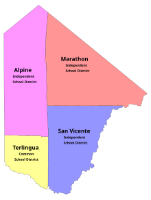
Alpine is a city in and the county seat of Brewster County, Texas, United States. The population was 5,905 at the 2010 census. The town has an elevation of 4,462 feet (1,360 m), and the surrounding mountain peaks are over 1 mile (1.6 km) above sea level. A university, hospital, library, and retail make Alpine the center of the sprawling 12,000 square miles (3,108,000 ha) but wide open Big Bend area including Brewster, Presidio, and Jeff Davis counties.

<span class="mw-page-title-main">Study Butte-Terlingua, Texas</span> Former CDP in Texas, United States

Study Butte-Terlingua was a census-designated place (CDP) in Brewster County, Texas, United States. The population was 267 at the 2000 census. For the 2010 census it was split into two CDPs, Study Butte and Terlingua.

<span class="mw-page-title-main">Big Bend National Park</span> U.S. national park located in West Texas, bordering Mexico

Big Bend National Park is an American national park located in West Texas, bordering Mexico. The park has national significance as the largest protected area of Chihuahuan Desert topography and ecology in the United States, and was named after a large bend in the Rio Grande/Río Bravo. The park protects more than 1,200 species of plants, more than 450 species of birds, 56 species of reptiles, and 75 species of mammals. Additional park activities include scenic drives, programs led by Big Bend park rangers, and stargazing.

<span class="mw-page-title-main">Big Bend (Texas)</span> Geographic region in the western part of the state of Texas in the United States

The Big Bend is part of the Trans-Pecos region in southwestern Texas, United States along the border with Mexico, north of the prominent bend in the Rio Grande for which the region is named. Here the Rio Grande passes between the Chisos Mountains in Texas and the Sierra Madre Oriental in Mexico as it changes from running east-southeast to north-northeast. The region covers three counties: Presidio County to the west, Brewster County to the east, and Jeff Davis County to the north.

<span class="mw-page-title-main">Terlingua, Texas</span> Census-designated place in Texas, United States

Terlingua is a mining district and census-designated place (CDP) in southwestern Brewster County, Texas, United States. It is located near the Rio Grande and the villages of Lajitas and Study Butte, Texas, as well as the Mexican state of Chihuahua. The discovery of cinnabar, from which the metal mercury is extracted, in the mid-1880s brought miners to the area, creating a city of 2,000 people. The only remnants of the mining days are a ghost town of the Howard Perry-owned Chisos Mining Company and several nearby capped and abandoned mines: the California Hill, the Rainbow, the 248, and the Study Butte mines. The mineral terlinguaite was first found in the vicinity of California Hill.

<span class="mw-page-title-main">Chisos Mountains</span> Mountain range in Texas, United States

The Chisos Mountains, also known as the Chisos, are a mountain range located in the Big Bend area of the Trans-Pecos region of Texas, United States. The mountain system covers 40 square miles and is contained entirely within the boundaries of Big Bend National Park, making it the only mountain range in the United States fully contained within a national park. The Chisos Mountains are the southernmost mountain range in the mainland United States.

<span class="mw-page-title-main">Trans-Pecos</span> Far west region in US state of Texas

The Trans-Pecos, as originally defined in 1887 by the Texas geologist Robert T. Hill, is the distinct portion of Texas that lies west of the Pecos River. The term is considered synonymous with Far West Texas, a subdivision of West Texas. The Trans-Pecos is part of the Chihuahuan Desert, the largest desert in North America. It is the most mountainous and arid portion of the state, and most of its vast area is sparsely populated. Among the nine counties in the region are the five largest counties by area in Texas and eight of the eleven largest in the state. The area is known for the natural environment of the Big Bend and the gorge of the Rio Grande, part of which has been designated a National Wild and Scenic Rivers System. With the notable exceptions of Big Bend Ranch State Park, Big Bend National Park and the Guadalupe Mountains National Park, the vast majority of the Trans-Pecos region consists of privately owned ranchland. However, most of the region's population reside in the El Paso metropolitan area. Besides El Paso and its metropolitan area, the major cities are Pecos (12,916), Fort Stockton (8,466), and Alpine (6,035). All other settlements have under 5,000 people.

<span class="mw-page-title-main">Texas State Highway 118</span>

State Highway 118 is a 155.3-mile (249.9 km) state highway in the U.S. state of Texas that runs from Big Bend National Park north to Kent and passes through the towns of Study Butte, Alpine, and Fort Davis. SH 118 is maintained by the Texas Department of Transportation (TxDOT). The road lies entirely within the Trans-Pecos region of Texas. SH 118 is a two-lane road along its length except for a section in Alpine where the route follows the path of U.S. Route 67 and U.S. Route 90. All of the route except for the 2.8-mile (4.5 km) section between Big Bend National Park and Farm to Market Road 170 is included in the Texas Historical Commission's Texas Mountain Trail.

<span class="mw-page-title-main">Boquillas, Texas</span> Village in Texas, United States

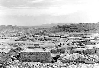
Boquillas was a small settlement in Texas, United States, located on the northern banks of the Rio Grande. It was located within Brewster County, five miles (8 km) northeast of San Vicente. The place existed to service the mining operations at Boquillas del Carmen, Mexico, just across the Rio Grande.

<span class="mw-page-title-main">Farm to Market Road 170</span>

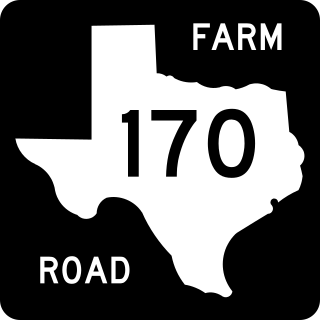
Farm to Market Road 170 is a 114.6-mile (184.4 km) highway maintained by the Texas Department of Transportation (TxDOT) in Presidio and Brewster counties in Texas. The route, known locally as the River Road, runs along the United States side of the Rio Grande which in Texas forms the international boundary between the U.S. and Mexico. The road runs from Candelaria through the city of Presidio as well as several smaller communities and former settlements to State Highway 118 in Study Butte near Big Bend National Park. The road also passes through the southern portion of Big Bend Ranch State Park.

<span class="mw-page-title-main">Lajitas, Texas</span> Unincorporated community in Texas, United States

Lajitas is an unincorporated community in Brewster County, Texas, United States, near the Big Bend National Park. According to the Handbook of Texas, the community had a population of 75 in 2010.

<span class="mw-page-title-main">Big Bend Ranch State Park</span> State park in Texas, United States

Big Bend Ranch State Park is a 311,000-acre (126,000 ha) state park located on the Rio Grande in Brewster and Presidio counties, Texas. It is the largest state park in Texas. The closest major town is Presidio, Texas. The state park's head office is located in Lajitas, Texas at the Barton Warnock Visitor Center. It includes Colorado Canyon.

<span class="mw-page-title-main">Study Butte, Texas</span> Census-designated place in Texas, United States

Study Butte is a census-designated place (CDP) in Brewster County, Texas, United States. The population was 233 at the 2010 census. At the 2000 census, the area was part of the Study Butte-Terlingua CDP.

<span class="mw-page-title-main">Foley County, Texas</span> County in Texas

Foley County is a defunct county in the U.S. state of Texas. It was located in the Big Bend area of far West Texas in what is now Brewster County.

<span class="mw-page-title-main">Glenn Springs, Texas</span> Ghost Town in Texas, United States

Glenn Springs is an uninhabited place in the state of Texas, United States, which is of historical importance. The Glenn Springs area was a natural spring providing water for Apache and Kiowa routing the Grand Indian Crossing passage at Boquillas. The Comanche tribes beseech the fresh water crossing on the Comanche Trail during their equine incursions from and to the Mexican Plateau, Sierra Madre Oriental, and the Trans-Mexican Volcanic Belt regions of Mexico.

<span class="mw-page-title-main">Castolon</span> United States historic place

Castolon, also known as La Harmonia Ranch and Campo Santa Helena, was a small community in southwestern Texas, United States, located in what is now Big Bend National Park along the Rio Grande. The location was first settled in 1901 by Cipriano Hernandez, who farmed the area and built the original Castolon Store, now known as the Alvino House.

Arick Village is the unofficial name of a portion of the Terlingua Ranch unincorporated community located in Brewster County, Texas, United States. Arick Village is located east of Highway 118, and west of 9-Point Mesa. Big Bend National Park and Big Bend Ranch State Park are located nearby.

<span class="mw-page-title-main">Homer Wilson Ranch</span> United States historic place

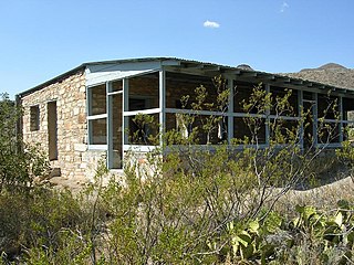
The Homer Wilson Ranch, also known as the Blue Creek Ranch, was one of the largest ranches in the early twentieth century in what would become Big Bend National Park in the U.S. state of Texas. The ranch was established by Homer Wilson in 1929 at Oak Springs to the west of the Chisos Mountains. Ultimately comprising 44 sections of land, amounting to more than 28,000 acres (11,000 ha), the Oak Canyon-Blue Creek Ranch was acquired by the State of Texas in 1942 for incorporation into the new park. A large portion of the ranch comprised portions of the old G4 Ranch, established by John and Clarence Gano in the 1880s. Wilson's ranch focused on sheep and goats, the first such large operation in the Big Bend area. Wilson continued to live at the ranch until his death in 1943; his family moved from the ranch the next year. Wilson, born in Del Rio, Texas in 1892, had studied petroleum engineering at the Missouri School of Mines and was a World War I veteran. The ranch, with the headquarters at Oak Springs and its operational center at Blue Creek, was one of the largest in Texas, and the most significant ranch in Big Bend.

References

  1. "Find a County". National Association of Counties. Archived from the original on May 31, 2011. Retrieved 2011-06-07.
  2. U.S. States by size
  3. 1 2 "U.S. Census Bureau QuickFacts: Brewster County, Texas". United States Census Bureau. Retrieved January 31, 2022.
  4. "Mescalero Apache History and Culture". Mescalero Apache Telecom, Inc. Archived from the original on July 14, 2011. Retrieved December 13, 2010.
  5. 1 2 3 Kohout, Martin Donell (June 12, 2010). "Brewster County, Texas". Handbook of Texas Online. Texas State Historical Association. Retrieved December 13, 2010.
  6. Folsom, Bradley (July 23, 2015). "La Junta de los Ríos". Handbook of Texas Online. Texas State Historical Association. Retrieved December 13, 2010.
  7. Kohout, Martin Donell (June 15, 2010). "Kokernot Spring". Handbook of Texas Online. Texas State Historical Association. Retrieved December 13, 2010.
  8. Chipman, Donald E (June 15, 2010). "Pedro de Rábago y Terán". Handbook of Texas Online. Texas State Historical Association. Retrieved December 13, 2010.
  9. Blake, Robert Bruce (June 15, 2010). "Hugo Oconór". Handbook of Texas Online. Texas State Historical Association. Retrieved December 13, 2010.
  10. "The Comanche Trail". National Park Service. Retrieved December 13, 2010.
  11. Hewitt, Harry P (June 15, 2010). "Edvard Emil (Emilio) Langberg". Handbook of Texas Online. Texas State Historical Association. Retrieved December 13, 2010.
  12. Klepper, Dan (2009). 100 Classic Hikes Texas: Panhandle Plains / Pineywoods / Gulf Coast / South Texas Plains / Hill Country / Big Bend Country / Prairies & Lakes. Mountaineers Books. pp. 170–172. ISBN   978-1-59485-075-2.
  13. "Alpine, Texas". Texas Escapes. Texas Escapes – Blueprints For Travel, LLC. Retrieved December 13, 2010.
  14. Thompson, Richard A (June 12, 2010). "Camp Pena Colorado". Handbook of Texas Online. Texas State Historical Association. Retrieved December 13, 2010.
  15. Ochoa, Ruben E (June 15, 2010). "August Santleben". Handbook of Texas Online. Texas State Historical Association. Retrieved December 13, 2010.
  16. Werner, George C (June 15, 2010). "Galveston, Harrisburg and San Antonio Railway". Handbook of Texas Online. Texas State Historical Association. Retrieved December 13, 2010.
  17. Kohout, Martin Donell (June 15, 2010). "Alfred Stevens Gage". Handbook of Texas Online. Texas State Historical Association. Retrieved December 13, 2010.
  18. Kohout, Martin Donell (June 9, 2010). "A. S. Gage Ranches". Handbook of Texas Online. Texas State Historical Association. Retrieved December 13, 2010.
  19. Ramos, Mary G; Reavis, Dick; Vandivier, Kevin (2004). Compass American Guides: Texas, 3rd Edition. Compass America Guides. p. 66. ISBN   978-0-676-90502-1.
  20. Metz, Leon Claire (2002). The Encyclopedia of Lawmen, Outlaws, and Gunfighters. Facts on File. pp. 94–95. ISBN   978-0-8160-4543-3.
  21. "James Buchanan Gillett 1856–1937". Texas Ranger Hall of Fame. Texas Ranger Hall of Fame and Museum. Retrieved December 13, 2010.
  22. Skelton, Bart. "A Ranch Fit For A Ranger". Guns & Ammo. Archived from the original on January 25, 2013. Retrieved December 13, 2010.
  23. Kohout, Martin Donell (June 15, 2010). "Joseph Daniel Jackson". Handbook of Texas Online. Texas State Historical Association. Retrieved December 13, 2010.
  24. Peterson's (2008). Colleges in the South: Compare Colleges in Your Region. Peterson's. p. 194. ISBN   978-0-7689-2695-8.
  25. "Terlingua". Texas Escapes. Texas Escapes – Blueprints For Travel, LLC. Retrieved December 13, 2010.
  26. Kohout, Martin Donell (June 15, 2010). "Glenn Spring Raid". Handbook of Texas Online. Texas State Historical Association. Retrieved December 13, 2010.
  27. Nelson, Barney (2002). God's Country or Devil's Playground. Austin, TX: University of Texas Press. p. 66. ISBN   978-0-292-75580-2.
  28. "Big Bend". National Park Service. Retrieved December 13, 2010.
  29. Melroy, Jennifer (August 7, 2020). "A complete break down of the U.S. National Parks by Size". National Park Obsessed. Retrieved October 30, 2020.
  30. "Big Bend Ranch State Park". Texas Parks and Wildlife Department. Retrieved December 13, 2010.
  31. Patoski, Joe Nick (November 1992). "Chili Relations". Texas Monthly. pp. 78, 80, 82, 85–86.
  32. "2010 Census Gazetteer Files". United States Census Bureau. August 22, 2012. Retrieved April 19, 2015.
  33. Geological Survey Bulletin, Issue 1350, Geological Survey (U.S.) page 831, Grace C. Keroher (1970)
  34. "Geolex — Word publications". ngmdb.usgs.gov. Retrieved January 5, 2017.
  35. Kottek, M.; Grieser, J.; Beck, C.; Rudolf, B.; Rubel, F. (2006). "Main Köppen-Geiger Climate Classes for US counties". Schweizerbart Science Publishers. Retrieved March 25, 2016.
  36. 1 2 3 4 5 6 7 8 9 "US COOP Station Map". Western Regional Climate Center, Desert Research Institute. Archived from the original on May 3, 2015. Retrieved May 5, 2015.
  37. "ALPINE, TEXAS (410174), Period of Record Monthly Climate Summary". Western Regional Climate Center, Desert Research Institute. Retrieved May 5, 2015.
  38. "CASTOLON, TEXAS (411524), Period of Record Monthly Climate Summary". Western Regional Climate Center, Desert Research Institute. Retrieved May 5, 2015.
  39. "CHISOS BASIN, TEXAS (411715), Period of Record Monthly Climate Summary". Western Regional Climate Center, Desert Research Institute. Retrieved May 5, 2015.
  40. "LAJITAS, TEXAS (414950), Period of Record Monthly Climate Summary". Western Regional Climate Center, Desert Research Institute. Retrieved May 5, 2015.
  41. "MARATHON, TEXAS (415579), Period of Record Monthly Climate Summary". Western Regional Climate Center, Desert Research Institute. Retrieved May 5, 2015.
  42. "PANTHER JUNCTION, TEXAS (416792), Period of Record Monthly Climate Summary". Western Regional Climate Center, Desert Research Institute. Retrieved May 9, 2015.
  43. "PERSIMMON GAP, TEXAS (416959), Period of Record Monthly Climate Summary". Western Regional Climate Center, Desert Research Institute. Retrieved May 8, 2015.
  44. "STUDY BUTTE, TEXAS (418714), Period of Record Monthly Climate Summary". Western Regional Climate Center, Desert Research Institute. Retrieved March 22, 2016.
  45. "TERLINGUA RANCH, TEXAS (418926), Period of Record Monthly Climate Summary". Western Regional Climate Center, Desert Research Institute. Retrieved March 24, 2016.
  46. "Decennial Census by Decade". US Census Bureau.
  47. "Texas Almanac: Population History of Counties from 1850–2010" (PDF). Texas Almanac. Archived (PDF) from the original on October 9, 2022. Retrieved April 19, 2015.
  48. "Explore Census Data". data.census.gov. Retrieved May 19, 2022.
  49. "Explore Census Data". data.census.gov. Retrieved May 19, 2022.
  50. "About the Hispanic Population and its Origin". www.census.gov. Retrieved May 18, 2022.
  51. Estimates of the Population by Age, Sex, and Race/Ethnicity for July 1, 2015 for State of Texas (PDF), July 15, 2015, archived from the original (PDF) on May 4, 2017, retrieved June 8, 2017
  52. "2020 CENSUS - SCHOOL DISTRICT REFERENCE MAP: Brewster County, TX" (PDF). U.S. Census Bureau. Archived (PDF) from the original on October 9, 2022. Retrieved June 22, 2022. - Text list
  53. "Jessi Milam". U.S. Department of Education. May 11, 2020. Retrieved June 16, 2021.
  54. "Texas Education Code Sec. 130.193. ODESSA COLLEGE DISTRICT SERVICE AREA".
  55. 1 2 Federal Communications Commission Reports: Decisions, Reports, and Orders of the Federal Communications Commission of the United States. U.S. Government Printing Office. 1985. p.  182.
  56. Leip, David. "Dave Leip's Atlas of U.S. Presidential Elections". uselectionatlas.org. Retrieved July 19, 2018.
  1. Note: the US Census treats Hispanic/Latino as an ethnic category. This table excludes Latinos from the racial categories and assigns them to a separate category. Hispanics/Latinos can be of any race. [50]

Further reading

29°48′43″N103°15′06″W / 29.81185°N 103.2517°W / 29.81185; -103.2517