South River City, Austin, Texas

Last updated
South River City, Austin, Texas
Neighborhood boundaries

South River City is a community located in Austin, Texas. Also frequently called Travis Heights, the neighborhood is located south of the city's urban core, just below Lake Lady Bird in South Austin. The area encompasses a portion of ZIP code 78704.

Contents

South River City is bounded to the west by South Congress Avenue and the Bouldin Creek neighborhood, to the south by Oltorf Road and to the east by Interstate 35 and East Riverside-Oltorf Combined Neighborhood Planning Area. To the north, South River City abuts Lake Lady Bird and Riverside Drive. South River City together with the St. Edward's neighborhood located directly to the south, comprise a City of Austin Combined Planning Area called Greater South River City. [1]

The area known as South River City developed in the late 19th and early 20th century as Austin's first planned urban communities south of the Colorado River. Swisher's Addition and Fairview Park, the first two attempts at settlement in present-day South River City were troubled by the lack of transportation with Downtown Austin. However, the concrete Congress Avenue Bridge was completed in 1910, thus laying the groundwork for a neighborhood boom in the 1920s and 1930s. Many of the homes built were single-family, and some of those that remain are Victorian-era structures with gingerbread trim, Craftsman-influenced bungalows, and housed influenced by the Prairie School style. Many houses have gabled or hipped roofs and deep porches. [2]

History

The Swisher Addition and birth of South Congress

Bungalow in Travis Heights. Travis Heights Austin - Saint Ceciia.jpg
Bungalow in Travis Heights.
Map of Swisher's Addition Swisher's Addition, South Austin.jpg
Map of Swisher's Addition

As was the case with other South Austin neighborhoods, the area around present-day South River City was slower to develop. Prior to the late 19th century, transportation to and from Downtown Austin was dependent on ferries and pontoon bridges.

James Swisher settled on a bluff in present-day South Austin with his family in 1846, and initially operated a tavern and a hotel. It was Swisher who granted Travis County the right-of-way to begin construction of a highway to San Antonio in 1852. Sensing the commercial opportunities that the new highway would bring, Swisher also began operating a ferry service across the Colorado River that same year. The establishment of Swisher's ferry and the Post Road in the early 1850s encouraged modest settlement in South Austin, particularly along the road, such as the Texas School for the Deaf in 1856. Further growth was halted by the outbreak of the U.S. Civil War and Reconstruction. Until a wooden bridge was finally built in 1876, South Austinites were dependent on ferry service and pontoon bridges to get to and from Downtown Austin. The bridge made South Austin more accessible than ever before, and in 1877 John Milton Swisher (James' son) subdivided 23 acres of the family farm along the San Antonio Road. It was to become Austin's first urban addition south of the Colorado River. [3]

Platted in 1877, it was noted as an addition to "South Austin" rather than Austin, perhaps acknowledging South Austin's separate identity from the capital city. Swisher allotted a very generous 120 foot right-of-way through the center of his grid-style residential addition. The wide avenue was laid out in a direct line with Congress Avenue on the north side of the river. This visionary and civic act dedicated a grand view from Swisher's farm to the public domain. [4] South Congress Avenue, in spite of being separated from the downtown portion of the street by about a mile over the Colorado River and low-lying areas, preserved the major approach to the Capitol and city center for future residents and visitors. A permanent and fully paved connection from Bouldin Creek to the north side of the river would not be complete for another 50 years. Streets were named Monroe, James, Annie, Nellie, Elizabeth, Mary, Johanna, Eva, Newton and Brackenridge. These names have survived to the present.

Swisher's Addition was not immediately successful. The wooden bridge collapsed in 1883, and while an iron bridge was built later that same decade, the concrete Congress Avenue Bridge and streetcar lines did not extend to South Austin until about 1910. Because this impeded would-be residents from being able to commute to downtown jobs with ease, development was slow and South Congress Avenue remained a country road through a largely rural landscape throughout the remainder of 19th century.

Fairview Park

Despite Swisher's minimal success, other developers tried their luck in South Austin. In 1886 Charles Newning bought the northern portion of the Swisher farm with plans of developing an “upscale, owner-occupied, garden suburb." In contrast to Swisher's grid-style addition on the high, relatively flat ground of the area, Newning's development was created over a hilly area with two creeks through it and numerous city views from its hillsides and terraces. Newning’s vision became Fairview Park – named because this area offered a “fair view” of the city from the bluffs.

Mr. Newning’s ideal development was never realized in large part because he did not anticipate the extent to which commercial development would occur on South Congress, the difficulty of crossing the river, and the distance from town. Before the turn of the century a number of Victorian homes were built on the large lots. Development, however, was so sparse that starting in the 1910s lots were subdivided into smaller parcels. In the 1920s and 1930s, small bungalows and cottages were built on these smaller lots. A much altered and scaled-back Fairview Park was not built out until the 1940s.

Travis Heights

Following the completion of the concrete Congress Avenue Bridge in 1910, pedestrians, automobiles and Austin's streetcar system were able to reach South River City with ease and the area began to grow. In 1913, General William Harwood Stacy, Charles Newning’s partner, and Stacy’s sons began development of Travis Heights. Travis Heights was the most heavily promoted subdivision of its time. Stacy ran streetcars full of prospective buyers out to Travis Heights from the Capitol to see the area before the homes were even built and gave away Ford Touring cars as part of a promotional campaign. He also incorporated deed restrictions against multi-family and commercial development in his subdivision to reassure buyers that Travis Heights would remain a residential enclave.

Based on his earlier experience with Charles Newning and Fairview Park, General Stacy laid out his South River City subdivision with both curving and grid streets and provided lot sizes and prices to fit a range of customers, from the builders of modest bungalows to grand home sites with commanding vistas. Travis Heights was an immediate success and a great surge of home building took place in the 1920s, so that by the General's death in 1928, 600 lots had been sold and more than 160 homes built. [5]

Demographics

According to data from the U.S. Census Bureau, the population of the area defined as South River City was 6,357 in 2009, across an area of 1.307 square miles. The population density per square miles is 4,862 people per square mile and is, as a result, notably higher than the citywide average for Austin (2,610 people per square miles). The racial breakdown is 73% white, 24% Hispanic/Latino, 2% black and 15 other. The median ages of males and females in the neighborhood are 31.3 and 34.6, slightly above the citywide median ages of 29.6 and 30.2, respectively. Median household income in 2009 in South River City was $41,179, compared with $50,132 for Austin at large. In 2009, the average estimated value of detached houses in the area was $387,271 (39.0% of all units), compared with $$286,025 for the rest of the city. [6]

Recreation

Perhaps the greatest contribution Stacy made to the future livability of not only Travis Heights, but the entire South River City Neighborhood, was the dedication of land adjacent to Blunn Creek and the bluff which drops down to Lake Lady Bird as public parks. Stacy’s sons, Harwood and Gillespie, added more and along Blunn Creek. This parkland later became known as Stacy Park. While Stacy Park was intended as a major recreational area, it also served as a natural divider between Travis Heights and the Fairview Park and Swisher subdivisions. [7]

Education

Travis Heights Elementary School TravisheightsES.JPG
Travis Heights Elementary School

The neighborhood is zoned to the Austin Independent School District.

Related Research Articles

<span class="mw-page-title-main">Travis Heights, Austin, Texas</span> United States historic place

Travis Heights is a historic neighborhood in south Austin, Texas, United States, bounded by Lady Bird Lake on the north, Interstate 35 on the east, Congress Avenue on the west and Oltorf Street on the south. These boundaries include Fairview Park, an earlier suburb associated with the same developers, running from the west side of Blunn Creek to South Congress Avenue. Part of Travis Heights was stranded east of Interstate 35; many of the same streets to be found west of the highway continue east of it.

<span class="mw-page-title-main">Congress Avenue Historic District</span> Historic district in Texas, United States

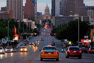
Congress Avenue is a major thoroughfare in Austin, Texas. The street is a six-lane, tree lined avenue that cuts through the middle of the city from far south Austin and goes over Lady Bird Lake leading to the Texas State Capitol in the heart of Downtown.

Seminole Heights is a historic neighborhood and district located in central Tampa. It includes many early 20th century bungalow homes and historic buildings. It was an early residential area of Tampa connected by streetcar. The area had an economic downturn in the late 20th century marked by increased crime, but has since seen a resurgence with new restaurants, brew pubs and independent businesses opening up. The neighborhood's historic homes, eclectic shops and gourmet restaurants are an increasing draw.

<span class="mw-page-title-main">Old West Austin Historic District</span> Historic district in Texas, United States

The Old West Austin Historic District is a residential community in Austin, Texas, United States. It is composed of three neighborhoods located on a plateau just west of downtown Austin: Old Enfield, Pemberton Heights, and Bryker Woods. Developed between 1886 and 1953, the three historic neighborhoods stretch from Mopac Expressway east to Lamar Boulevard, and from 13th Street north to 35th Street. It borders Clarksville Historic District and the West Line Historic District to the south.

<span class="mw-page-title-main">Neighborhoods of Jacksonville</span>

There are more than 500 neighborhoods within the area of Jacksonville, Florida, the largest city in the contiguous United States by area. These include Downtown Jacksonville and surrounding neighborhoods. Additionally, greater Jacksonville is traditionally divided into several major sections with amorphous boundaries: Northside, Westside, Southside, and Arlington, as well as the Jacksonville Beaches.

<span class="mw-page-title-main">Neighborhoods in Spokane, Washington</span>

Neighborhoods in Spokane, Washington are officially grouped by the Spokane City Council into three main city council districts: 1, 2, and 3. Each city council district contains multiple, official neighborhoods that are recognized with a neighborhood council. Informally, neighborhoods are colloquially grouped by local geographical, geological, cultural, or historical features The list of neighborhoods below is organized based on the official designations by the City of Spokane. Unofficial neighborhoods and districts are listed within the official neighborhood in which they are located.

<span class="mw-page-title-main">History of Austin, Texas</span> Aspect of history

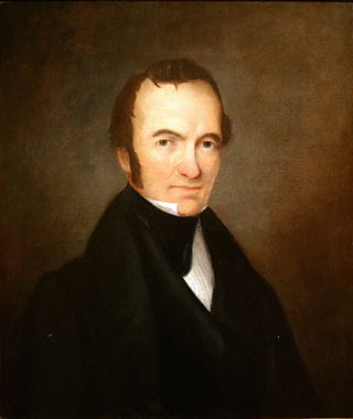
After declaring its independence from Mexico in March, 1836, the Republic of Texas had numerous locations as its seat of government. This being seen as a problem attempts were made to select a permanent site for the capital. January, 1839, with Mirabeau B. Lamar as the newly elected president, a site selection commission of five commissioners was formed. Edward Burleson had surveyed the planned townsite of Waterloo, near the mouth of Shoal Creek on the Colorado River, in 1838; it was incorporated January 1839. By April of that year the site selection commission had selected Waterloo to be the new capital. A bill previously passed by Congress in May, 1838, specified that any site selected as the new capital would be named Austin, after the late Stephen F. Austin; hence Waterloo upon selection as the capital was renamed Austin. The first lots in Austin went on sale August 1839.

Columbus, the state capital and Ohio's largest city, has numerous neighborhoods within its city limits. Neighborhood names and boundaries are not officially defined. They may vary or change from time to time due to demographic and economic variables.

<span class="mw-page-title-main">Downtown Austin</span> Neighborhood in Austin, Texas

Downtown Austin is the central business district of Austin, Texas, United States. The area of the district is bound by Lamar Boulevard to the west, Martin Luther King Jr. Boulevard to the north, Interstate 35 to the east, and Lady Bird Lake to the south.

<span class="mw-page-title-main">South Congress</span> Neighborhood in Austin, Texas, United States

South Congress is a neighborhood located on South Congress Avenue in Austin, Texas, United States. It is also a nationally known shopping and cultural district known for its many eclectic small retailers, restaurants, music and art venues and, more recently, food trucks.

<span class="mw-page-title-main">Barton Hills, Austin, Texas</span>

Barton Hills is a neighborhood in Austin, Texas. It is located in south Austin, and encompasses part of ZIP code 78704.

<span class="mw-page-title-main">Glennwood Estates (Decatur)</span>

Glennwood Estates is a historic neighborhood located in the northeast section of Decatur, Georgia. It is a residential neighborhood chiefly of single-family homes including a nature preserve and an adjoining park. At least a third of the homes were built in the 1920s and were relatively large for the time. Glenn Creek and the South Fork of Peachtree Creek Tributary run through the neighborhood.

<span class="mw-page-title-main">Sections of Billings, Montana</span>

The city of Billings, Montana is subdivided into 11 sections for geographic and planning purposes.

East Riverside-Oltorf is a neighborhood in Austin, Texas, located southeast of the city's urban core. The East Riverside, Parker Lane, and Pleasant Valley neighborhoods together form the East Riverside-Oltorf Combined Neighborhood Planning Area. The region is bounded on the north by Lake Lady Bird, to the east by Grove Boulevard and the Montopolis neighborhood, Texas State Highway 71 to the south, and Interstate 35 and South River City to the west.

<span class="mw-page-title-main">West Line Historic District (Austin, Texas)</span> Historic district in Texas, United States

The West Line Historic District is a residential community in central Austin, Texas, United States. The district encompasses an approximately 90-block tract of land located west of downtown. Bounded by Baylor Street to the east, Fifth Street to the south, Thirteenth Street to the north and Texas State Highway Loop 1 to the west. It is located south of the Old West Austin Historic District and southeast of the Clarksville Historic District.

Galindo is a neighborhood in Austin, Texas. The area covers part of ZIP code 78704 in south Austin.

<span class="mw-page-title-main">Pemberton Heights, Austin, Texas</span>

Pemberton Heights is a neighborhood of Austin, Texas, and part of the Old West Austin Historic District. The area is bounded by Northwood Road on the north, Lamar Boulevard/Shoal Creek on the east, 24th Street/Windsor Road on the south, and Texas State Highway Loop 1 ("MoPac") on the west. It is Austin's wealthiest and most historic neighborhood.

<i>Larry Monroe Forever Bridge</i> Memorial mural in Austin, Texas, U.S.

The Larry Monroe Forever Bridge is a bridge mural and memorial to Austin broadcaster and musical scholar Larry Monroe. The bridge's two low walls are decorated with mosaic tiles relating to Monroe and the music he played on Austin radio for more than 30 years. Artist Stefanie Distefano designed and directed the project. The bridge is located on East Side Drive as it crosses Blunn Creek between Stacy Park and Little Stacy Park in the Travis Heights neighborhood in South Austin, Texas.

<span class="mw-page-title-main">1928 Austin city plan</span> Plan commissioned by Austin City Council

The 1928 Austin city plan was commissioned in 1927 by the City Council of Austin, Texas. It was developed by consulting firm Koch & Fowler, which presented the final proposal early the next year. The major recommendations of this city plan related to Austin's street plan, its zoning code, and the development of major industries and civic features, but it is most remembered for institutionalizing housing segregation by designating East Austin as the city's negro district.

References

  1. "Neighborhood Planning: Greater South River City". City of Austin. Retrieved Nov 24, 2011.
  2. "History of Travis Heights". Travis Heights Fairview Park Historic District. 2010. Retrieved Nov 24, 2011.
  3. "Greater South River City Neighborhood Plan" (PDF). City of Austin. Sep 29, 2005. Retrieved Nov 24, 2011.
  4. Carole, Carole E. "Swisher, James Gibson". Handbook of Texas Online. Retrieved Nov 24, 2011.
  5. McGraw, Marburger & Associates. "History of South Congress" . Retrieved October 31, 2011.
  6. "South River City Detailed Profile". City-data.com. Retrieved Nov 23, 2011.
  7. Clark-Webb, Mike (Dec 4, 1998). "Our Little Town: Travis Heights Arrives". Austin Chronicle. Retrieved Nov 24, 2011.

30°15′29″N97°46′52″W / 30.25806°N 97.78111°W / 30.25806; -97.78111