
Zilker is a neighborhood in south central Austin, Texas. It extends south of Lady Bird Lake, approximately bounded by the Union Pacific Railway to the southeast/south, Barton Skyway to the south, Rabb Road and Azie Morton Road to the west and Lady Bird Lake to the north.
Lincoln Terrace is a historic and diverse neighborhood in the Eastside district of Northeast Oklahoma City, located on either side of Lincoln Blvd just south of the Oklahoma State Capitol, between NE 13th and NE 23rd streets.] Most homes in the area were built during the decade (1920–30) after the erection of the state capitol. The neighborhood has undergone a renaissance in recent years in part as a result of the expansion of the Oklahoma Health Center district, anchored by the University of Oklahoma Health Sciences Center, on its south side.

Travis Heights is a historic neighborhood in south Austin, Texas, United States, bounded by Lady Bird Lake on the north, Interstate 35 on the east, Congress Avenue on the west and Oltorf Street on the south. These boundaries include Fairview Park, an earlier suburb associated with the same developers, running from the west side of Blunn Creek to South Congress Avenue. Part of Travis Heights was stranded east of Interstate 35; many of the same streets to be found west of the highway continue east of it.
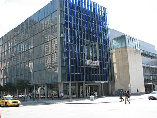
The Neal Kocurek Memorial Austin Convention Center is a multi-purpose convention center located in Austin, Texas. The building is the home of the Texas Rollergirls, and was also home to the Austin Toros basketball team, until their move to the Cedar Park Center in nearby Cedar Park in 2010. The facility is also the primary "home base" for the internationally renowned South by Southwest technology, music and film conference/festival, held annually in March.

KAZI is a listener-supported, non-commercial community radio station in Austin, Texas, United States. The transmitter site is located in Southwest Austin and the station has studios in Northeast Austin. It is owned by Austin Community Radio, Inc., a Texas non-profit entity founded April 22, 1975.
KTXZ is an AM radio station, operating at 1560 kHz, licensed to West Lake Hills, Texas, and is owned by Encino Broadcasting LLC. The station airs a Tejano music format. A transmitter site is located in Northeast Austin and the station has studios along Loop 360 in Southwest Austin.

KOKE-FM is a commercial FM radio station broadcasting a progressive country radio format. Licensed to Thorndale, Texas, KOKE-FM serves the Greater Austin radio market. The station is owned by Genuine Austin Radio, LP. The transmitter site is located on County Road 470 in Coupland, Texas. The studios and offices are along Loop 360 in Southwest Austin.
Circle C Ranch is a large master-planned community in southwest Austin, Texas, USA. Development of Circle C Ranch began in 1982, with the first homes in the community in built in 1986. During development, the subdivision was featured prominently in a long and contentious environmental legal battle regarding urban development in the vicinity of Barton Springs and over Edwards Aquifer. The controversy surrounding its development and later annexation by the city of Austin was a landmark in municipal annexation rights in Texas.

Oak Hill is an unincorporated community and collection of neighborhoods located in southwest Austin, Texas.

French Place is a neighborhood in Austin, Texas. It is located east of IH-35 on the north side of town.

Barton Hills is a neighborhood in Austin, Texas. It is located in south Austin, and encompasses part of ZIP code 78704.

The Windsor Park neighborhood is located in Austin, Texas, and bounded on the south by 51st St. to Tilley St., southwest to Philomena St., southeast along the Central Texas Emergency Command Center and Troublemaker Studios property line to Zach Scott St., east to Manor Rd., northeast to Northeast Dr., northwest/north to US Highway 290, east to IH35, then south to E 51st St.
Saint John is a neighborhood of Austin, Texas within the 78752 zip code. Geographically, the neighborhood straddles Interstate 35. It is bounded on the west by Middle Fiskville Road and Twincrest, on the south by U.S. 290, on the north by Anderson Lane, and on the east by Cameron Road.
Allandale, Austin, Texas is a neighborhood in North Central Austin, in the U.S. State of Texas known for its large lots, mature trees, and central location.
Bryker Woods is an older Austin, Texas, central city neighborhood developed in the 1930s, the center of which is approximately located at 30°18′17″N97°45′06″W. It is predominantly a mix of young and old families and zoned as a single-family neighborhood composed of mostly small homes in good condition, most of which are over 50 years old. The Bryker Woods neighborhood is also part of the Old West Austin Historic District. Bryker Woods has its own elementary school, Bryker Woods Elementary, and is convenient to retail and recreational facilities.
Westgate is a neighborhood in Austin, Texas, located southwest of the city's urban core. It includes ZIP code 78745.
Spyglass-Barton's Bluff is a neighborhood in Austin, Texas. It is located southwest of the city's urban core, and encompasses ZIP codes 78746 and 78704.
Scenic Brook is a neighborhood located in southwest Austin, Texas. Scenic Brook is located in ZIP codes 78735 and 78736. The boundaries are the intersections of Highway 290 and Highway 71 to on the north, south, and east sides, and Covered Bridge Drive and Scenic Brook Drive on the west side. The Pinnacle Campus of Austin Community College is a landmark on the southeast side of the neighborhood.
Belterra is a 1,600-acre (650 ha) unincorporated community and census-designated place (CDP) in Hays County, Texas, United States. It is 18 miles (29 km) southwest of downtown Austin. It was first listed as a CDP in the 2020 census with a population of 6,170.
North Burnet–Gateway (NBG) is a 2,300 acre neighborhood in northwest Austin, Texas bordered by Walnut Creek to the north, US 183 to the south and southwest, Metric Boulevard to the east, Braker Lane to the northwest, and MoPac to the west.
