Related Research Articles

Hampden Township is the largest municipality by population in Cumberland County, Pennsylvania. The population was 28,044 at the 2010 census, up from 24,135 at the 2000 census.

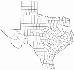
Barton Creek is a census-designated place (CDP) in Travis County, Texas, United States. As of the 2010 census, the CDP population was 3,077.
Bee Cave is a city located in Travis County, Texas, United States. Its population was 9,144 as of the 2020 census.
Briarcliff is a village in Travis County, Texas, United States. The population was 1,438 at the 2010 census.

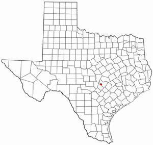
Lost Creek is an affluent upper-middle-class neighborhood and census-designated place (CDP) of approximately 4,500 people in Travis County, Texas, United States. The census tract is bordered by Capital of Texas Highway to the east, Barton Creek to the south, Barton Creek Boulevard to the west, and Bee Caves Road to the north. The Lost Creek CDP encompasses several small neighborhoods—Parkstone, Woods of Westlake, Camelot, and Knollwood—as well as the largest and most populous Lost Creek neighborhood.

Manor is a city in Travis County, Texas, United States. Manor is located 12 miles northeast of Austin and is part of the Austin-Round Rock metropolitan area. The population was 13,652 at the 2020 census. Manor is one of the faster-growing suburbs of Austin. The city was the 7th fastest growing suburb in America in 2018 by Realtor.com and the 17th best small suburb to live in by U.S. News and World Report in 2019.

San Leanna is a village in Travis County, Texas, United States. The population was 497 at the 2010 census.

Shady Hollow is a census-designated place (CDP) in southwestern Travis County, Texas, United States, and is partially in the City of Austin. It is located ten miles (16 km) southwest of Downtown Austin, near the Travis/Hays county line. The population was 5,004 at the 2010 census.

Wells Branch is a census-designated place (CDP) in Travis County, Texas, United States. The population was 14,000 at the 2020 census.

Anderson Mill is a neighborhood of Austin and a former census-designated place (CDP) in Travis and Williamson counties in the U.S. state of Texas. The population was 7,199 at the 2010 census.

Jollyville is a neighborhood in the northern part of Austin, Texas, in the United States. In 2010 it was a census-designated place (CDP) in Travis and Williamson counties, but has since been annexed by Austin. The population of the CDP was 16,151 at the 2010 census.

Leander is a city in Williamson County and Travis County, Texas, United States. The population was 59,202 at the 2020 census and 67,124 at the 2021 census estimate. A suburb just north of Austin, and part of the Greater Austin metropolitan area, it was the fastest-growing city in the United States between 2018 and 2019.

Brentwood is a neighborhood in central Austin, Texas.
Saint John is a neighborhood of Austin, Texas within the 78752 zip code. Geographically, the neighborhood straddles Interstate 35. It is bounded on the west by Middle Fiskville Road and Twincrest, on the south by U.S. 290, on the north by Anderson Lane, and on the east by Cameron Road.
East Riverside-Oltorf is a neighborhood in Austin, Texas, located southeast of the city's urban core. The East Riverside, Parker Lane, and Pleasant Valley neighborhoods together form the East Riverside-Oltorf Combined Neighborhood Planning Area. The region is bounded on the north by Lake Lady Bird, to the east by Grove Boulevard and the Montopolis neighborhood, Texas State Highway 71 to the south, and Interstate 35 and South River City to the west.
North Shoal Creek is a neighborhood in north central Austin, Texas established in the 1960s.
The Wooten neighborhood of Austin, Texas is located in north central Austin. It is bounded by Burnet Road, Anderson Lane, and Research Blvd (183) and bisected by Ohlen Road.
East Dallas, also referred to by the East Dallas Chamber of Commerce as the Lake & Garden District, is an expansive area of numerous communities and neighborhoods in Dallas, Texas that border nearby suburban cities to the east such as Garland, Mesquite, and Balch Springs, Texas.
Galindo is a neighborhood in Austin, Texas. The area covers part of ZIP code 78704 in south Austin.
South River City is a community located in Austin, Texas. Also frequently called Travis Heights, the neighborhood is located south of the city's urban core, just below Lake Lady Bird in South Austin. The area encompasses a portion of ZIP code 78704.
References
- ↑ "Census Tract 13.08, Travis County, Texas". U.S. Census Bureau. Retrieved 20 January 2023.
- ↑ "P1: RACE". U.S. Census Bureau. Retrieved 20 January 2023.
- ↑ "S1901I NCOME IN THE PAST 12 MONTHS (IN 2021 INFLATION-ADJUSTED DOLLARS)". U.S. Census Bureau. Retrieved 17 January 2023.
- ↑ "Dawson Neighborhood Overview". Trulia. Retrieved 19 January 2023.
- ↑ "Maps and Directions". St. Edward's University. Retrieved 20 January 2023.
- ↑ "Gillis Neighborhood Park". Austin Parks Foundation. Retrieved 19 January 2023.
- ↑ "Cumberland Community Garden". FindHelp. Retrieved 20 January 2023.