Clarksville Historic District (Austin, Texas)

Last updated

Clarksville Historic District
Sweet home baptist church austin 2014.jpg
The Sweet Home Baptist Church serves as the focal point of the neighborhood.
Clarksville Historic District (Austin, Texas)
LocationBounded by W. Lynn, Waterston, W. 10th and MO-PAC Expwy., Austin, Texas
Coordinates 30°16′51″N97°45′44″W / 30.28083°N 97.76222°W / 30.28083; -97.76222
Area305 acres
Built1871
ArchitectEdmerson, Willis
Architectural style American Craftsman Bungalow, Late Victorian
NRHP reference No. 76002070 [1]
Added to NRHPDecember 1, 1976

The Clarksville Historic District in Austin, Texas, is an area located west of downtown Austin near Lady Bird Lake and just northeast of the intersection of the Missouri Pacific Railroad and West Tenth Street. Many historic homes and structures are located within the Clarksville Historic District. While Clarksville is geographically part of the Old West Austin Historic District, it is distinct from the two historic neighborhoods of Old Enfield, which lies immediately to the north on the eastern side of Texas State Highway Loop 1 (commonly referred to as Mopac), and Tarrytown, which is situated to the west and northwest on the western side of Mopac.

Contents

Founded by freedman Charles Clark in 1871, Clarksville is the oldest surviving freedman's town ‒ the original post-Civil War settlements founded by former African-American slaves ‒ west of the Mississippi River. The historic district was inducted into the National Register of Historic Places in 1976 in recognition of its unique and valuable history. [2]

History

The area was originally part of a 365-acre (148 ha) tract of land belonging to Texas Governor Elisha Pease, and in 1871 was sold to Charles Clark, a freedman who would start the community that now bears his name. Clark built a house on what is now West Tenth Street and subdivided the remainder of the land to other freedmen. Just a mile west of Austin, Clarksville soon became a de facto part of the city, especially when the International-Great Northern Railroad laid tracks nearby in the 1870s. The Sweet Home Baptist Church, a cornerstone of the community to this day, was founded prior to 1882, and a school existed as early as the 1890s.

At least six communities of emancipated slaves existed around Austin, including Wheatville (founded by James Wheat and home to celebrated Austin black leader Reverend Jacob Fontaine), Pleasant Hill, and Clarksville. [3]

However, early in the twentieth century developers began to realize the land value of Clarksville, which lay near growing downtown Austin. Austin city policy aimed to concentrate the local black population in the east, and pressured black communities in west Austin, such as Clarksville and Wheatville, to move. In 1918 the Austin school board closed the Clarksville school. Clarksville residents were later forced to use city services in east Austin or none at all. The 1928 Austin city plan embraced Jim Crow and recommended "that all the facilities and conveniences be provided the Negroes in this district, as an incentive to draw the Negro population to this area." Most Clarksville residents endured the lack of services, however, and refused to move. [4] In 1968 Clarksville residents unsuccessfully protested a state and local plan to build a highway along the Missouri Pacific Railroad, which extended along the western boundary of Clarksville. The completed Mopac Expressway sliced through the community, forcing 33 families to leave.

Despite pressure to move to segregated east Austin, Clarksville retained its African-American identity throughout the 20th century. Residents of Clarksville began requesting Austin city funds for the improvement and preservation in 1964, but dirt streets crossed the area until 1975, and a creek carrying sewage periodically flooded homes. However, in 1975 the Texas Historical Commission designated a two-block-wide strip of Clarksville as a historic district, and the city paved the streets with asphalt. In 1976 the Austin City Council approved the use of $100,000 from a federal housing and community-development grant to pave streets permanently, improve drainage, and expand the neighborhood playground. Another $100,000 was designated for housing rehabilitation. The same year Clarksville residents and supporters defeated a plan to build a thoroughfare through the community connecting Interstate 35 and the MoPac Expressway. Later in the 1970s, as rising land values drove lower-income residents out of the area, the Clarksville Community Development Corporation was established to provide low-income options to preserve the community's character. The district was added to the National Register of Historic Places in 1976. [2]

Clarksville today

Many European immigrants settled in Clarksville throughout the early 1900s, building a community still felt today. Anthony Colanetta settled in Clarksville and opened Anthony's Laundry & Cleaners at the corner of West 12th Street and West Lynn in 1950. Colanetta also built a drugstore that he leased to his friend Hylton Nau. The Nau Enfield Drugstore soda fountain eventually closed in 2023 [5] . In 1979 Craig Weller and Mark Skiles opened Clarksville Natural Grocery, and a year later they joined forces with John Mackey to open the first Whole Foods, then called Clarksville Natural Grocery. [6]

Related Research Articles

<span class="mw-page-title-main">Near South Side, Chicago</span> Community area in Chicago

The Near South Side is a community area of Chicago, Illinois, United States, just south of the downtown central business district, the Loop. The Near South Side's boundaries are as follows: North—Roosevelt Road ; South—26th Street; West—Chicago River between Roosevelt and 18th Street, Clark Street between 18th Street and Cermak Road, Federal between Cermak Road and the Stevenson Expressway just south of 25th Street, and Clark Street again between the Stevenson and 26th Street; and East—Lake Michigan.

<span class="mw-page-title-main">Hyde Park (Austin, Texas)</span> United States historic place

Hyde Park is a neighborhood and historic district in Austin, Texas. Located in Central Austin, Hyde Park is defined by 38th Street to the south, 45th Street to the north, Duval Street to the east, and Guadalupe Street to the west. It is situated just north of the University of Texas and borders the neighborhoods of Hancock and North Loop.

<span class="mw-page-title-main">Mechanicsville, Knoxville</span> United States historic place

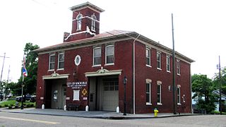
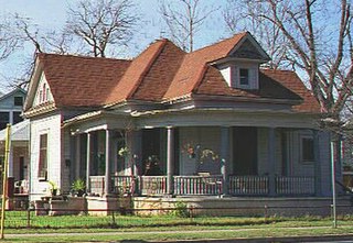
Mechanicsville is a neighborhood in Knoxville, Tennessee, United States, located northwest of the city's downtown area. One of the city's oldest neighborhoods, Mechanicsville was established in the late 1860s for skilled laborers working in the many factories that sprang up along Knoxville's periphery. The neighborhood still contains a significant number of late-19th-century Victorian homes, and a notable concentration of early-20th-century shotgun houses. In 1980, several dozen properties in Mechanicsville were added to the National Register of Historic Places as the Mechanicsville Historic District. The neighborhood was also designated as a local historic district in 1991, subject to historic zoning and design standards.

<span class="mw-page-title-main">Old West Austin Historic District</span> Historic district in Texas, United States

The Old West Austin Historic District is a residential community in Austin, Texas, United States. It is composed of three neighborhoods located on a plateau just west of downtown Austin: Old Enfield, Pemberton Heights, and Bryker Woods. Developed between 1886 and 1953, the three historic neighborhoods stretch from Mopac Expressway east to Lamar Boulevard, and from 13th Street north to 35th Street. It borders Clarksville Historic District and the West Line Historic District to the south.

<span class="mw-page-title-main">Tarrytown, Austin, Texas</span> Neighborhood of Austin, Texas

Tarrytown is a neighborhood located west of Downtown Austin, Texas. The neighborhood is bordered by Lake Austin Boulevard on the south, Lake Austin on the west, West 35th Street on the north and Mopac Expressway on the east. Major roads in the area include Exposition Boulevard, Enfield Road and Windsor Road. Tarrytown also encompasses the sub-neighborhood of Brown Herman.

<span class="mw-page-title-main">Southgate–Lewis House</span> Historic house in Texas, United States

The Southgate–Lewis House is located one mile east of the Texas State Capitol in Austin, Texas, at 1501 East 12th Street. The house was constructed in 1888, and now stands as an African-American historical landmark. It is also a repository for African-American History and Culture in the region of east Austin, which historically became an African-American neighborhood. The City of Austin has now declared this region to be "Austin's Black Cultural District." The Southgate–Lewis House is located in the center of the "African American Cultural Heritage District".

<span class="mw-page-title-main">Downtown Austin</span> Neighborhood in Austin, Texas

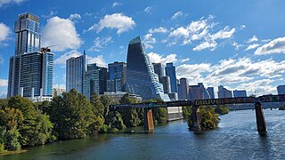
Downtown Austin is the central business district of Austin, Texas, United States. The area of the district is bound by Lamar Boulevard to the west, Martin Luther King Jr. Boulevard to the north, Interstate 35 to the east, and Lady Bird Lake to the south.

West Campus is a neighborhood in central Austin, Texas west of Guadalupe Street and its namesake, the University of Texas at Austin. Due to its proximity to the university, West Campus is heavily populated by college students.

Northwest Hills, sometimes referred to as Far West after its main street, is a suburban neighborhood in the northwestern part of Austin, Texas, United States.

<span class="mw-page-title-main">Willow–Spence Streets Historic District</span> Historic district in Texas, United States

The Willow–Spence Streets Historic District is a neighborhood that lies east of downtown Austin, Texas. Its houses, churches, and commercial buildings were built in the early twentieth century. It is bounded roughly by Interstate 35 to the west, East César Chávez Street to the north, and Spence Street to the south. It extends a few houses east of San Marcos Street along Willow and Canterbury Streets. It thus includes portions of Willow, Spence, Canterbury, San Marcos, and Waller Streets. It was added to the National Register of Historic Places in 1985.

Allandale, Austin, Texas is a neighborhood in North Central Austin, in the U.S. State of Texas known for its large lots, mature trees, and central location.

<span class="mw-page-title-main">West Line Historic District (Austin, Texas)</span> Historic district in Texas, United States

The West Line Historic District is a residential community in central Austin, Texas, United States. The district encompasses an approximately 90-block tract of land located west of downtown. Bounded by Baylor Street to the east, Fifth Street to the south, Thirteenth Street to the north and Texas State Highway Loop 1 to the west. It is located south of the Old West Austin Historic District and southeast of the Clarksville Historic District.

Hancock is a neighborhood in Austin, Texas. Located in North Central Austin, Hancock encompasses ZIP code 78751 and 78705.

East César Chávez, historically and originally named Masontown or Masonville, is a neighborhood in Austin, Texas. It is located in the central-east part of Austin's urban core on the north bank of the Colorado River. The neighborhood encompasses much of ZIP code 78702.

<span class="mw-page-title-main">Midtown-Edmondson, Baltimore</span> Neighborhood of Baltimore in Maryland, United States

Midtown-Edmondson is a mixed-use neighborhood in western Baltimore City developed mostly between the 1880s and the 1910s. The neighborhood is mainly composed of residential rowhouses, with a mixed-used business district along Edmondson Avenue, and industrial warehouses and buildings dotted along the CSX railroads that bound its western edge.

<span class="mw-page-title-main">History of African Americans in Austin</span>

The history of African Americans in Austin dates back to 1839, when the first African American, Mahala Murchison, arrived. By the 1860s, several communities were established by freedmen that later became incorporated into the city proper. The relative share of Austin's African-American population has steadily declined since its peak in the late 20th century.

Wheatville was a historically black neighborhood in the city of Austin, Texas.

Blackland is a historically black neighborhood on the east side of Austin, Texas, located north of Martin Luther King, Jr. Blvd, south of Manor Road, east of I-35, and west of Chestnut Street. The neighborhood was originally known as Blacklands and was settled by Swedish immigrants, but evolved into a predominantly African-American neighborhood following the 1928 Austin city plan, which called for the relocation of non-white residents to the east side of the city. Up until the 1980s, the neighborhood was targeted for demolition to make way for an expansion of the University of Texas campus. In 1983, the Blackland Community Development Corporation was formed to build, purchase and maintain housing for low-income families and special populations.

<span class="mw-page-title-main">1928 Austin city plan</span> Plan commissioned by Austin City Council

The 1928 Austin city plan was commissioned in 1927 by the City Council of Austin, Texas. It was developed by consulting firm Koch & Fowler, which presented the final proposal early the next year. The major recommendations of this city plan related to Austin's street plan, its zoning code, and the development of major industries and civic features, but it is most remembered for institutionalizing housing segregation by designating East Austin as the city's negro district.

References

  1. "National Register Information System". National Register of Historic Places . National Park Service. March 13, 2009.
  2. 1 2 Thompson, Nolan. "Clarksville, YX (Travis County)". Handbook of Texas Online. Retrieved January 2, 2011.
  3. Clark-Madison, Mike (October 20, 1995). "The Clarksville Effect". Austin Chronicle. Retrieved January 2, 2011.
  4. Henneberger, John (1978). Clarksville, a Short History and a Historic Tour. Red River Women’s Press. ISBN   0-917968-17-4.
  5. https://austin.eater.com/2022/9/29/23377945/naus-enfield-drug-austin-closing-diner-pharmacy-clarksville-march-2023
  6. Gray, Ki (February 13, 2008). "A History Austin's Oldest Neighborhood Clarksville". American Chronicle. Retrieved January 2, 2011.