
The Northshore Mall is a shopping mall in Peabody, Massachusetts. As of 2022, the mall currently features Macy's in two locations, J. C. Penney, and Nordstrom.

Columbia Mall is an enclosed regional shopping mall in Grand Forks, North Dakota located at the intersection of 32nd Avenue South and Columbia Road. The mall opened in 1978, and was developed by the Dayton Hudson Corporation at a cost of roughly $20 million. Today, Columbia Mall features the traditional retailers JCPenney and Scheels, and also currently features several prominent specialty retailers which are American Eagle, Bath and Body Works, Hot Topic, Maurices, Men's Warehouse, and Zumiez. GK Development, Inc. of Barrington, Illinois, is the current owner of the mall.
In North American, Australian and New Zealand retail, an "anchor tenant", sometimes called an "anchor store", "draw tenant", or "key tenant", is a considerably larger tenant in a shopping mall, often a department store or retail chain. They are typically located at the ends of malls, sometimes in the middle. With their broad appeal, they are intended to attract a significant cross-section of the shopping public to the center. They are often offered steep discounts on rent in exchange for signing long-term leases in order to provide steady cash flows for the mall owners.

Valley View Center is a former mall located at Interstate 635 and Preston Road in north Dallas, Texas, U.S. It is owned and managed by Dallas-based Beck Ventures. The mall was formerly home to anchor stores that were once JCPenney, Macy's, Sears, and Dillard's. The demolition of the mall was completed in May 2023.
Paramus Park is a shopping mall located in Paramus, New Jersey, United States. It opened in 1974, is owned by Brookfield Properties, and has a gross leasable area (GLA) of 770,941 sq ft (71,622.8 m2).

Cary Towne Center was an indoor shopping mall in Cary, North Carolina. It was anchored by Belk, Dillard's, Macy's, JCPenney, and Sears.

Golf Mill Shopping Center, or simply Golf Mill, is a shopping center located at 239 Golf Mill Center in Niles, Illinois. The shopping mall has a gross leasable area of 1.1 million square feet (100,000 m2). It is managed by Sterling Retail Services. It borders the intersections of Golf Road, Milwaukee Avenue and Greenwood Avenue. The shopping mall has over 100 specialty shops, three anchor stores, an AMC Theatres, a grocery store, an XSport Fitness gym, and a 9-story office tower and other outparcels. Former anchors included Sears and Roebuck, and Kohl's.
Baybrook Mall is a shopping mall located near the Clear Lake City area in Houston, Texas; It has a Friendswood mailing address, but it is in the Houston city limits. The mall is located off Interstate 45, and it is also in proximity to Webster and the NASA Johnson Space Center. The anchor stores are Star Cinema Grill, Dave & Buster's, Dillard's, JCPenney, H&M, Macy's, and Forever 21. In late 2024, Living Spaces is moving into the space that was once Sears.
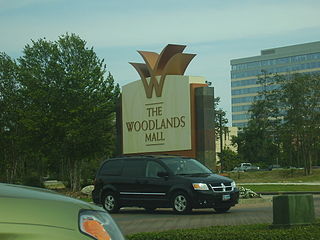
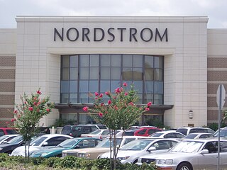
The Woodlands Mall is a two-story, enclosed shopping mall located at the intersection of Interstate 45 and Lake Woodlands Drive in the community of The Woodlands in unincorporated Montgomery County, Texas, United States, north of Houston. The Woodlands Mall features six anchor stores: Dick's Sporting Goods, Dillard's, Forever 21, JCPenney, Macy's, and Nordstrom. With a gross leasable area of 1,350,000 square feet (125,000 m2), The Woodlands Mall is considered a super-regional mall by industry definitions. The Woodlands Mall is managed by Brookfield Properties.

North Hill Centre is a shopping mall in Calgary, Alberta, Canada. It opened in 1958, and was Calgary's first shopping mall. The original anchor tenant was Simpsons-Sears, but it closed on January 8, 2018 and has since been replaced by Showhome Furniture.

The Harford Mall is a shopping mall owned by CBL & Associates Properties that is located near the junction of Maryland Route 24 and U.S. Route 1, about 32 miles (51 km) north of Baltimore, in Bel Air, Maryland, United States. Its anchor is Macy's. It is the only shopping mall in Harford County, Maryland. The mall was built on the previous site of the Bel Air Racetrack.
East Riverside-Oltorf is a neighborhood in Austin, Texas, located southeast of the city's urban core. The East Riverside, Parker Lane, and Pleasant Valley neighborhoods together form the East Riverside-Oltorf Combined Neighborhood Planning Area. The region is bounded on the north by Lake Lady Bird, to the east by Grove Boulevard and the Montopolis neighborhood, Texas State Highway 71 to the south, and Interstate 35 and South River City to the west.

The Arts & Entertainment District, or previously known as Omni, is a neighborhood of Downtown Miami, Florida. It is bound roughly by North 19th Street to the north, North 10th Street to the south, North West 2nd Avenue to the west, and Biscayne Boulevard to the east.
Westgate is a neighborhood in Austin, Texas, located southwest of the city's urban core. It includes ZIP code 78745.
Galindo is a neighborhood in Austin, Texas. The area covers part of ZIP code 78704 in south Austin.
Spyglass-Barton's Bluff is a neighborhood in Austin, Texas. It is located southwest of the city's urban core, and encompasses ZIP codes 78746 and 78704.
South River City is a community located in Austin, Texas. Also frequently called Travis Heights, the neighborhood is located south of the city's urban core, just below Lake Lady Bird in South Austin. The area encompasses a portion of ZIP code 78704.
Austin Country Club is a private golf club in the southern United States, located in Austin, Texas. Established 126 years ago in 1899, the club moved to its third and present site in 1984, a challenging layout designed by noted course architect Pete Dye.
Los Altos Center is a regional shopping mall in the Los Altos area of northeastern Long Beach, California along Bellflower Boulevard, 4 miles south of Lakewood Center Mall and 5 miles east of Downtown Long Beach.
Blackland is a historically black neighborhood on the east side of Austin, Texas, located north of Martin Luther King, Jr. Blvd, south of Manor Road, east of I-35, and west of Chestnut Street. The neighborhood was originally known as Blacklands and was settled by Swedish immigrants, but evolved into a predominantly African-American neighborhood following the 1928 Austin city plan, which called for the relocation of non-white residents to the east side of the city. Up until the 1980s, the neighborhood was targeted for demolition to make way for an expansion of the University of Texas campus. In 1983, the Blackland Community Development Corporation was formed to build, purchase and maintain housing for low-income families and special populations.
