
A bike path is a bikeway separated from motorized traffic and dedicated to cycling or shared with pedestrians or other non-motorized users. In the US a bike path sometimes encompasses shared use paths, "multi-use path", or "Class III bikeway" is a paved path that has been designated for use by cyclists outside the right of way of a public road. It may or may not have a center divider or stripe to prevent head-on collisions. In the UK, a shared-use footway or multi-use path is for use by both cyclists and pedestrians.

The Sellwood Bridge is a deck arch bridge that spans the Willamette River in Portland, Oregon, in the United States. The current bridge opened in 2016 and replaced a 1925 span that had carried the same name. The original bridge was Portland's first fixed-span bridge and, being the only river crossing for miles in each direction, the busiest two-lane bridge in Oregon. The Sellwood Bridge links the Sellwood and Westmoreland neighborhoods of Portland on the east side with Oregon Route 43/Macadam Avenue on the west side. At its east end it leads to Tacoma Street. The bridge is owned and operated by Multnomah County. The original span of 1925 was a steel truss bridge, while its 2016 replacement is a deck-arch-type bridge.

The Burrard Street Bridge is a four-lane, Art Deco style, steel truss bridge constructed in 1930–1932 in Vancouver, British Columbia, Canada. The high, five part bridge on four piers spans False Creek, connecting downtown Vancouver with Kitsilano via connections to Burrard Street on both ends. It is one of three bridges crossing False Creek. The other two bridges are the Granville Bridge, three blocks or 0.5 km (0.31 mi) to the southeast, and the Cambie Street Bridge, about 11 blocks or 2 km (1.2 mi) to the east. In addition to the vehicle deck, the Burrard Bridge has 2.6 m wide sidewalks and a dedicated cycling lane on both sides.

A subway, also known as an underpass, is a grade-separated pedestrian crossing which crosses underneath a road or railway in order to entirely separate pedestrians and cyclists from motor traffic or trains respectively.
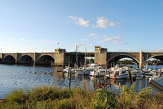
The Washington Bridge is a series of three bridges carrying Interstate 195, US Route 6, US Route 44, and U.S. Route 1A over the Seekonk River connecting India Point in Providence to Watchemoket Square in East Providence, Rhode Island. The historic portion of the bridge dating to 1930 serves as the pedestrian crossing, and bike link to the East Bay Bike Path. The pedestrian span is also a part of the Washington-Rochambeau National Historic Trail.

The Lamar Boulevard Bridge is a historic arch bridge carrying Texas State Highway Loop 343 over Lady Bird Lake in downtown Austin, Texas, United States. The bridge features six open-spandrel concrete arches spanning 659 feet (201 m) and carries tens of thousands of vehicles daily across the lake. Completed in 1942, the Lamar Boulevard Bridge was the second permanent bridge to cross the Colorado River, and one of the last Art Deco-style open-spandrel concrete arch bridges built in Texas. The bridge was named an Austin Landmark in 1993 and added to the National Register of Historic Places in 1994.

Blackfriars Bridge in London, Ontario, Canada is a wrought iron bowstring arch through truss bridge, crossing the North Thames River. The bridge was constructed in 1875 and carries single-lane vehicles, bicycles and pedestrians from Blackfriars Street to Ridout Street North.

The BP Pedestrian Bridge, or simply BP Bridge, is a girder footbridge in the Loop community area of Chicago, United States. It spans Columbus Drive to connect Maggie Daley Park with Millennium Park, both parts of the larger Grant Park. Designed by Pritzker Prize-winning architect Frank Gehry and structurally engineered by Skidmore, Owings and Merrill, it opened along with the rest of Millennium Park on July 16, 2004. Gehry had been courted by the city to design the bridge and the neighboring Jay Pritzker Pavilion, and eventually agreed to do so after the Pritzker family funded the Pavilion.

Toronto, Ontario, like many North American cities, has slowly been improving its cycling infrastructure. The number of cyclists in Toronto has been increasing progressively, particularly in the city's downtown core. As cycling conditions improve, a cycling culture has grown and alternatives such as automobiles are seen as less attractive. The politics of providing resources for cyclists, particularly dedicated bike lanes, has been contentious, particularly since the 2010s.

The Harbor Drive Pedestrian Bridge is a pedestrian and bicycle crossing along the Balboa Parkway "Park to Bay Link" over the San Diego Trolley and San Diego & Arizona Eastern Railroad tracks in downtown San Diego, California. The bridge connects otherwise disconnected segments of Park Boulevard, allowing pedestrians easier access between Petco Park/East Village and the waterfront. The Park Blvd Pedestrian Bridge is 550 feet (170 m) long which makes it one of the longest self-anchored pedestrian bridges in the world. The span measures 350 feet (110 m) while the remainder is approaches.

Cycling in Canada is experienced in various ways across a geographically huge, economically and socially diverse country. Among the reasons for cycling in Canada are for practical reasons such as commuting to work or school, for sports such as road racing, BMX, Mountain bike racing, freestyle BMX, as well as for pure recreation. The amount and quality of bicycle infrastructure varies widely across the country as do the laws pertaining to cyclists such as bicycle helmet laws which can differ by province.

Cycling infrastructure is all infrastructure cyclists are allowed to use. Bikeways include bike paths, bike lanes, cycle tracks, rail trails and, where permitted, sidewalks. Roads used by motorists are also cycling infrastructure, except where cyclists are barred such as many freeways/motorways. It includes amenities such as bike racks for parking, shelters, service centers and specialized traffic signs and signals. The more cycling infrastructure, the more people get about by bicycle.

A protected intersection or protected junction, also known as a Dutch-style junction, is a type of at-grade road junction in which cyclists and pedestrians are separated from cars. The primary aim of junction protection is to make pedestrians and cyclists safer and feel safer at road junctions.

The Western Gwinnett Bikeway is a multi-use trail under construction along Peachtree Industrial Boulevard in Gwinnett County. The trail will be 10 feet to 14 feet wide and traverse the cities of Norcross, Peachtree Corners, Berkeley Lake, Duluth, Suwanee, Sugar Hill and Buford. It is intended to be the spine of West Gwinnett’s trails and greenways, connecting parks, trails, businesses, schools and neighborhoods to the urban core.

The Adàwe Crossing is a pedestrian and cyclist bridge in Ottawa, Ontario, Canada, built across the Rideau River. It is located about 1,200 metres (1,300 yd) north (downstream) of the Highway 417 bridge and 800 metres (870 yd) south (upstream) from the Cummings Bridge. It was opened on December 4, 2015 and links the communities of Overbook and Sandy Hill.

A bicycle highway, also known as a cycling superhighway, fast cycle route or bike freeway, is an informal name for a bicycle path that is meant for long-distance traffic. There is no official definition of a bicycle highway. The characteristics of a cycle motorway mentioned by authorities and traffic experts include an absence of single-level intersections with motorized traffic, a better road surface and the absence of traffic lights. Bicycle highways are mentioned in connection with traffic jam. Owing to higher average speeds than normal cycling infrastructure, they provide an alternative to the car in commuter traffic. Often a cycle motorway follows the route of a railway or other linear infrastructure.

The West Fifth Street Bridge is a historic cantilever concrete girder bridge in downtown Austin, Texas. Built in 1931, the bridge carries Fifth Street across Shoal Creek to link central Austin with neighborhoods that were then the city's western suburbs. It is one of only a handful of curved cantilever girder bridges in Texas, built as part of the city's 1928 master plan for urban development and beautification. The bridge was added to the National Register of Historic Places in 2019.

Hiawatha LRT Trail is a 4.7-mile (7.6 km), multi-use path adjacent to a light-rail transit line in Minneapolis, Minnesota, United States, that is popular with bicycle commuters. Users travel along the Metro Blue Line and Hiawatha Avenue transit corridor, reaching downtown Minneapolis near an indoor sports stadium at the trail’s northern end, and reaching a bridge above Minnehaha Creek at the trail’s southern end. Hiawatha LRT Trail provides a vital link between several Minneapolis neighborhoods and the city’s downtown area.

Cycling infrastructure in the Canadian city of Halifax, Nova Scotia includes most regular streets and roads, bike lanes, protected cycle tracks, local street bikeways, and multi-use pathways.

The Expo Line Bikeway is a 12-mile (19 km) Los Angeles County, California rail with trail bicycle path and pedestrian route that travels roughly parallel to the Metro’s E Line train tracks between the Exposition Park area near the USC campus and downtown Santa Monica near the Pacific Ocean. The Expo Line Bikeway is one of two major bicycle routes in Los Angeles that share dedicated rights-of-way with mass transit, the other being the Orange Line Bikeway in the San Fernando Valley.


