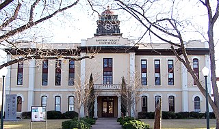
Bastrop County is located in the U.S. state of Texas. It is in Central Texas and its county seat is Bastrop.

The Austin Community College District (ACC) is a public community college system serving the Austin, Texas, metropolitan area and surrounding Central Texas communities. The college maintains numerous campuses, centers, and distance learning options to serve about 100,000 students in academic, continuing education and adult education programs.

Eanes Independent School District (EISD) is a school district headquartered in unincorporated Travis County, Texas (USA), in Greater Austin. Its enrollment is about 7,814 students, distributed among six elementary schools, two middle schools, and one high school. All nine schools are rated Exemplary - the highest designation possible - in the State of Texas 2009 accountability ratings, marking the second consecutive year for that accomplishment. The district's overall state is Exemplary, making Eanes ISD one of just two 5A districts in the state to receive that designation in 2009. Only 9.5 percent of districts statewide are rated exemplary. See the bottom of this page for more information about TEA accountability ratings.

Brentwood is a neighborhood in central Austin, Texas.
The city of San Antonio in the U.S. state of Texas is composed of a number of neighborhoods and districts, spreading out surrounding the central Downtown Area.

Oak Hill is an unincorporated community and collection of neighborhoods located in southwestern Austin, Texas, United States.
Canyon Creek is a residential neighborhood located in far northwest Austin, Texas. The neighborhood is located in ZIP Code 78726 and is bordered by Ranch to Market Road 2222 (RM 2222) on the south, Ranch to Market Road 620 (RM 620) on the west, Anderson Mill Road on the north, and a major headwater tributary of Bull Creek to the east as well as the Balcones Canyonlands National Wildlife Refuge. The major bisecting road is Boulder Lane, a loop which crosses RM 620 at the north and south entrances. The neighborhood is approximately 5 miles (8.0 km) from Lake Travis and Lake Austin.
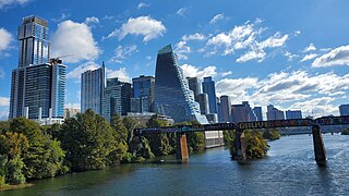
Downtown Austin is the central business district of Austin, Texas, United States. The area of the district is bound by Lamar Boulevard to the west, Martin Luther King Jr. Boulevard to the north, Interstate 35 to the east, and Lady Bird Lake to the south.

South Congress is a neighborhood located on South Congress Avenue in Austin, Texas, United States. It is also a nationally known shopping and cultural district known for its many eclectic small retailers, restaurants, music and art venues and, more recently, food trucks.

Barton Hills is a neighborhood in Austin, Texas. It is located in south Austin, and encompasses part of ZIP code 78704.
Saint John is a neighborhood of Austin, Texas within the 78752 zip code. Geographically, the neighborhood straddles Interstate 35. It is bounded on the west by Middle Fiskville Road and Twincrest, on the south by U.S. 290, on the north by Anderson Lane, and on the east by Cameron Road.
East Riverside-Oltorf is a neighborhood in Austin, Texas, located southeast of the city's urban core. The East Riverside, Parker Lane, and Pleasant Valley neighborhoods together form the East Riverside-Oltorf Combined Neighborhood Planning Area. The region is bounded on the north by Lake Lady Bird, to the east by Grove Boulevard and the Montopolis neighborhood, Texas State Highway 71 to the south, and Interstate 35 and South River City to the west.
Bryker Woods is an older Austin, Texas, central city neighborhood developed in the 1930s, the center of which is approximately located at 30°18′17″N97°45′06″W. It is predominantly a mix of young and old families and zoned as a single-family neighborhood composed of mostly small homes in good condition, most of which are over 50 years old. The Bryker Woods neighborhood is also part of the Old West Austin Historic District. Bryker Woods has its own elementary school, Bryker Woods Elementary, and is convenient to retail and recreational facilities.
Westgate is a neighborhood in Austin, Texas, located southwest of the city's urban core. It includes ZIP code 78745.
Spyglass-Barton's Bluff is a neighborhood in Austin, Texas. It is located southwest of the city's urban core, and encompasses ZIP codes 78746 and 78704.
Belterra is a 1,600-acre (650 ha) unincorporated community and census-designated place (CDP) in Hays County, Texas, United States. It is 18 miles (29 km) southwest of downtown Austin. It was first listed as a CDP in the 2020 census with a population of 6,170.
Granada Hills is a neighborhood located in southwest Austin, Texas. Granada Hills is located in ZIP code 78737. The neighborhood boundaries are FM 1826 on the south and east sides, Highway 290 and the Scenic Brook neighborhood to the north, and Southview Road and Belterra on the west side.
North Burnet–Gateway (NBG) is a 2,300 acre neighborhood in northwest Austin, Texas bordered by Walnut Creek to the north, US 183 to the south and southwest, Metric Boulevard to the east, Braker Lane to the northwest, and MoPac to the west.
Oak Hill is a ghost town in Bastrop County, Texas, United States. It is located four miles southwest of McDade, 12 miles southeast of Elgin, 13 miles northeast of Bastrop, and 37 miles southeast of Austin on the old Bastrop-McDade Road.
Blackland is a historically black neighborhood on the east side of Austin, Texas, located north of Martin Luther King, Jr. Blvd, south of Manor Road, east of I-35, and west of Chestnut Street. The neighborhood was originally known as Blacklands and was settled by Swedish immigrants, but evolved into a predominantly African-American neighborhood following the 1928 Austin city plan, which called for the relocation of non-white residents to the east side of the city. Up until the 1980s, the neighborhood was targeted for demolition to make way for an expansion of the University of Texas campus. In 1983, the Blackland Community Development Corporation was formed to build, purchase and maintain housing for low-income families and special populations.
