
The Bedford Center Historic District encompasses the historic heart of the town of Bedford, Massachusetts. It extends along Great Road between Bacon and Concord Roads, and includes primarily residential areas on adjacent side streets. The area includes the town's main civic buildings, its first cemetery, and a diverse array of residential architecture spanning more than two centuries. The district was listed on the National Register of Historic Places in 1977; its boundaries were adjusted in 2014 and its period of significance extended.

The Milton Center Historic District encompasses the historic 19th-century village center of Milton in the northwestern part of the town of Litchfield, Connecticut. Basically linear, it stretches from Milton Cemetery in the west to the junction of Milton and Shearshop Roads in the east, including houses, churches, schools, and the remains of industrial sites. The district was listed on the National Register of Historic Places in 1986.

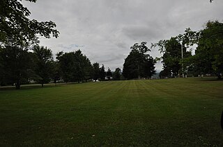
The Weathersfield Center Historic District encompasses a small cluster of buildings and a historic site at the geographic center of the town of Weathersfield, Windsor County, Vermont, United States. It includes the town's second church building, the home of its first settled minister, and an early stone animal pound. It was listed on the National Register of Historic Places in 1980.

The Bedford Presbyterian Church is a historic Presbyterian church building at 4 Church Road in Bedford, New Hampshire. The white clapboard structure was built in 1832 for a congregation organized in 1749 and was for many years the town's only church. The building was listed on the National Register of Historic Places in 2007. It is the oldest Presbyterian church building in the state and in the Presbytery of Northern New England.

The Waterville Village Historic District encompasses most of the history 19th and early 20th-century village center of Waterville, Vermont. The village grew from beginnings late in the 18th century to serve as a modest civic, commercial, and residential hub for the rural community. It was added to the National Register of Historic Places in 2007.
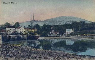
The Blue Hill Historic District encompasses the historic village center of the town of Blue Hill, Maine. The village, established in 1762, is a well-preserved collection of buildings, many of them built before 1840. Most of the older buildings are residential in character; the modest collection of commercial and civic buildings were mostly built between 1880 and 1940. The district was listed on the National Register of Historic Places in 1980.

The Brattleboro Downtown Historic District encompasses most of the central business district of the town of Brattleboro, Vermont. Extending along Main Street between Whetstone Brook and a junction with Pultney Road and Linden and Walnut Streets, this area includes many of the town's prominent civic and institutional buildings. The area's development took place primarily in the 19th century, with surviving buildings from both the 18th and early 20th centuries. The district was listed on the National Register of Historic Places in 1983, and was enlarged in 2004 to include Plaza Park and the Holstein Building on the south side of Whetstone Brook.

The Canal Street–Clark Street Neighborhood Historic District encompasses a compact 19th-century working-class neighborhood of Brattleboro, Vermont. Most of its buildings are modest vernacular wood-frame buildings, erected between 1830 and 1935; there are a few apartment blocks, and one church. The district was listed on the National Register of Historic Places in 1993.

The Putney Village Historic District encompasses most of the main village and town center of Putney, Vermont. Settled in the 1760s, the village saw its major growth in the late 18th and early 19th century, and includes a cohesive collection with Federal and Greek Revival buildings, with a more modest number of important later additions, including the Italianate town hall. The district was listed on the National Register of Historic Places in 1986.

The Rockingham Village Historic District encompasses the traditional village center of the town of Rockingham, Vermont. Settled in the 18th century, the district, located mainly on Meeting House Road off Vermont Route 103, includes a variety of 18th and 19th-century houses, and has been little altered since a fire in 1908. It notably includes the 18th-century National Historic Landmark Rockingham Meeting House. The district was listed on the National Register of Historic Places in 2008.

The Danby Village Historic District encompasses much of the town center of Danby, Vermont. It is centered on a stretch of Main Street, roughly between Depot Street and Brook Road. The village has a cohesive collection of mid-19th century architecture, mostly residential, with a modest number of later additions. The district was listed on the National Register of Historic Places in 1983.
The Middletown Springs Historic District encompasses most of the village center of Middletown Springs, Vermont. Oriented around the crossroads junction of Vermont Routes 140 and 133, the village has a well-preserved collection of mainly mid-19th century architecture, including a significant number of Italianate buildings. The district was listed on the National Register of Historic Places in 1985.

The Quechee Historic Mill District encompasses the historic heart of the village of Quechee, Vermont, a well-preserved 19th-century mill village. Extending along Quechee Main Street between the Old Quechee Road and the Quechee-West Hartford Road, the village was settled in the 1760s, and has an industrial history extending into the 20th century. It was listed on the National Register of Historic Places in 1997.

The Stockbridge Common Historic District encompasses the central portion of a rural 19th-century village center in Stockbridge, Vermont. Including the town common as well as a few buildings and an adjacent cemetery, it is a well-preserved example of a village bypassed by economic development during the 19th century industrial period. It was listed on the National Register of Historic Places in 1990.
The Charlotte Center Historic District encompasses the historic 19th-century town center of Charlotte, Vermont. Settled c. 1790 and developed mainly in the mid-19th century, the village, stretched along Church Hill Road west of Hinesburg Road, retains a well-preserved 19th-century atmosphere of residential, civic, and commercial buildings. The district was listed on the National Register of Historic Places in 1984.

The Kents Corner Historic District encompasses a well-preserved 19th-century crossroads hamlet in Calais, Vermont. Centered on the junction of Kent Hill Road, Old West Church Road, and Robinson Cemetery Road, it developed as a stagecoach stop with a small industrial presence. It was listed on the National Register of Historic Places in 1973, and substantially enlarged in 2006.
The Jericho Center Historic District encompasses much of the central village of Jericho, Vermont. Centered on the town green at the meeting point of Brown's Trace, Varney Road, and Bolger Hill Road, the center is a well-preserved Vermont country village developed mainly in the 19th and early 20th centuries. It was listed on the National Register of Historic Places in 1983.
The Waitsfield Common Historic District encompasses the original town center settlement of Waitsfield, Vermont, at the junction of Joslin Hill, Common, East, and North Roads. Located about 1 mile (1.6 km) from the town's present main village and center, it was laid out in 1793, and includes the triangular town common, a cemetery, and a number of houses built mainly between 1793 and 1841. The district was listed on the National Register of Historic Places in 2001.

The Shelburne Village Historic District encompasses the central portion of the main village of Shelburne, Vermont. Centered on the junction of United States Route 7 with Harbor and Falls Roads, the district's architecture traces the town's history from the 18th to early 20th century. It was listed on the National Register of Historic Places in 1990.

The Peacham Corner Historic District encompasses much of the historic village center of Peacham, Vermont. The village's period of greatest growth and importance between the town's founding as a hill town in the late 18th century, and 1860, when significant development effectively ended. As a result, the village lacks Victorian features often found in other rural communities. The district was listed on the National Register of Historic Places in 2003.


