National Register of Historic Places listings in Caledonia County, Vermont

Last updated

Location of Caledonia County in Vermont Map of Vermont highlighting Caledonia County.svg
Location of Caledonia County in Vermont

This is a list of the National Register of Historic Places listings in Caledonia County, Vermont.

Contents

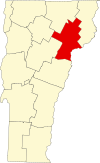
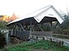
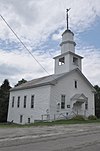
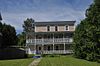
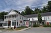
This is intended to be a complete list of the properties and districts on the National Register of Historic Places in Caledonia County, Vermont, United States. Latitude and longitude coordinates are provided for many National Register properties and districts; these locations may be seen together in a map. [1]

There are 57 properties and districts listed on the National Register in the county, including 1 National Historic Landmark.


    This National Park Service list is complete through NPS recent listings posted May 26, 2023. [2]

Contents: Counties in Vermont
Addison - Bennington - Caledonia - Chittenden - Essex - Franklin - Grand Isle - Lamoille - Orange - Orleans - Rutland - Washington - Windham - Windsor
Map all coordinates using: OpenStreetMap  
Download coordinates as: KML

Current listings

[3] Name on the Register [4] ImageDate listed [5] Location City or townDescription
1 Barnet Center Historic District
Barnet Center Historic District Barnet, Vermont (5960862044).jpg
Barnet Center Historic District
July 12, 1984
(#84003440)
Barnet Center Rd. at Ferguson Rd.
44°18′44″N72°05′09″W / 44.312222°N 72.085833°W / 44.312222; -72.085833 (Barnet Center Historic District)
Barnet
2 Benoit Apartment House-74 Pearl Street
Benoit Apartment House-74 Pearl Street StJohnsburyVT 439PearlStreet.jpg
Benoit Apartment House-74 Pearl Street
May 6, 1994
(#94000378)
439 Pearl St.
44°25′11″N72°01′02″W / 44.419722°N 72.017222°W / 44.419722; -72.017222 (Benoit Apartment House-74 Pearl Street)
St. Johnsbury
3 Benoit Apartment House-76 Pearl Street
Benoit Apartment House-76 Pearl Street StJohnsburyVT 447PearlStreet.jpg
Benoit Apartment House-76 Pearl Street
May 6, 1994
(#94000379)
447 Pearl St.
44°25′09″N72°01′02″W / 44.419167°N 72.017222°W / 44.419167; -72.017222 (Benoit Apartment House-76 Pearl Street)
St. Johnsbury
4 Bradley Covered Bridge
Bradley Covered Bridge Bridges in Lyndonville, Vermont.jpg
Bradley Covered Bridge
June 13, 1977
(#77000096)
North of Lyndon Center on Center St. over Miller Run
44°32′31″N72°00′38″W / 44.541944°N 72.010556°W / 44.541944; -72.010556 (Bradley Covered Bridge)
Lyndon
5 Building at 143 Highland Avenue
Building at 143 Highland Avenue HardwickVT 143HighlandAvenue.jpg
Building at 143 Highland Avenue
April 6, 2000
(#00000358)
143 Highland Ave.
44°30′22″N72°22′07″W / 44.506111°N 72.368611°W / 44.506111; -72.368611 (Building at 143 Highland Avenue)
Hardwick
6 Burklyn Hall
Burklyn Hall BurklynHall 1.jpg
Burklyn Hall
May 7, 1973
(#73000191)
Bemis Hill Rd.
44°35′04″N71°57′49″W / 44.584444°N 71.963611°W / 44.584444; -71.963611 (Burklyn Hall)
East Burke
7 Burrington Covered Bridge
Burrington Covered Bridge LyndonVT BurringtonCoveredBridge.jpg
Burrington Covered Bridge
June 13, 1974
(#74000203)
Northeast of Lyndonville off VT 114 over the East Branch of the Passumpsic River
44°33′13″N71°58′12″W / 44.553611°N 71.97°W / 44.553611; -71.97 (Burrington Covered Bridge)
Lyndon
8 Caledonia No. 9 Grange Hall December 26, 2017
(#100001937)
88 Church St.
44°31′21″N72°18′27″W / 44.522396°N 72.307407°W / 44.522396; -72.307407 (Caledonia No. 9 Grange Hall)
East Hardwick
9 Centre Covered Bridge
Centre Covered Bridge CENTRE COVERED BRIDGE.jpg
Centre Covered Bridge
June 20, 1974
(#74000204)
North of Lyndonville off U.S. Route 5, over the Passumpsic River
44°32′36″N72°00′06″W / 44.543333°N 72.001667°W / 44.543333; -72.001667 (Centre Covered Bridge)
Lyndon
10 Chamberlin Mill Covered Bridge
Chamberlin Mill Covered Bridge Chamberlin Covered Bridge.jpg
Chamberlin Mill Covered Bridge
July 30, 1974
(#74000205)
West of VT 114 over the South Wheelock Branch of Passumpsic River
44°30′59″N72°01′00″W / 44.516389°N 72.016667°W / 44.516389; -72.016667 (Chamberlin Mill Covered Bridge)
Lyndon
11 Christian Union Society Meetinghouse
Christian Union Society Meetinghouse WaldenVT ChristianUnionSocietyMeetinghouse.jpg
Christian Union Society Meetinghouse
May 23, 1980
(#80000385)
Bayley-Hazen Military Rd.
44°28′43″N72°17′30″W / 44.478611°N 72.291667°W / 44.478611; -72.291667 (Christian Union Society Meetinghouse)
South Walden
12 Cobb School
Cobb School Cobb School, Hardwick VT - side view.jpg
Cobb School
September 30, 1993
(#93001007)
Junction of Hardwick Town Highway 10 (Cobb School Rd.) and Sanborn Cemetery Rd.
44°33′23″N72°20′32″W / 44.556389°N 72.342222°W / 44.556389; -72.342222 (Cobb School)
Hardwick
13 Cote Apartment House
Cote Apartment House StJohnsburyVT CoteApartmentHouse.jpg
Cote Apartment House
May 6, 1994
(#94000377)
16 Elm St.
44°25′18″N72°00′40″W / 44.421667°N 72.011111°W / 44.421667; -72.011111 (Cote Apartment House)
St. Johnsbury
14 Darling Estate Historic District
Darling Estate Historic District DarlingtonEstateHD 4.jpg
Darling Estate Historic District
August 23, 2011
(#10000911)
Darling Hill Rd. in Burke and Lyndon; Pinkham Rd. in Burke [6]
44°35′24″N71°57′37″W / 44.59°N 71.9603°W / 44.59; -71.9603 (Darling Estate Historic District)
Burke and Lyndon
15 Darling Inn
Darling Inn LyndonvilleVT DarlingInn.jpg
Darling Inn
November 24, 1980
(#80000386)
Depot St.
44°32′03″N72°00′16″W / 44.534167°N 72.004444°W / 44.534167; -72.004444 (Darling Inn)
Lyndonville
16 J. R. Darling Store
J. R. Darling Store GrotonVT JRDarlingStore.jpg
J. R. Darling Store
May 12, 2004
(#04000442)
1334 Scott Highway
44°12′44″N72°11′41″W / 44.212222°N 72.194722°W / 44.212222; -72.194722 (J. R. Darling Store)
Groton
17 District 6 School House
District 6 School House LyndonVT District6Schoolhouse.jpg
District 6 School House
February 1, 2006
(#05001588)
73 Cemetery Circle
44°32′20″N72°00′46″W / 44.538980°N 72.012648°W / 44.538980; -72.012648 (District 6 School House)
Lyndon
18 Downtown Hardwick Village Historic District
Downtown Hardwick Village Historic District Jeudevine Memorial Library.jpg
Downtown Hardwick Village Historic District
September 30, 1982
(#82001698)
Main, Church, Maple, and Mill Sts.; also Brush St.
44°30′19″N72°21′50″W / 44.505278°N 72.363889°W / 44.505278; -72.363889 (Downtown Hardwick Village Historic District)
Hardwick Brush St. represents a boundary increase
19 Elkins Tavern
Elkins Tavern PeachamVT ElkinsTavern.jpg
Elkins Tavern
December 18, 1978
(#78000228)
Bayley-Hazen Rd.
44°19′22″N72°09′58″W / 44.322680°N 72.165998°W / 44.322680; -72.165998 (Elkins Tavern)
Peacham
20 Fairbanks Museum
Fairbanks Museum FairbanksMuseum StJohnsburyVT.JPG
Fairbanks Museum
January 2, 2008
(#07001344)
1302 Main St.
44°25′12″N72°01′13″W / 44.42°N 72.020278°W / 44.42; -72.020278 (Fairbanks Museum)
St. Johnsbury
21 Franklin Fairbanks House
Franklin Fairbanks House StJohnsburyVT FranklinFairbanksHouse.jpg
Franklin Fairbanks House
September 27, 1980
(#80000329)
357 Western Ave.
44°25′02″N72°01′39″W / 44.417222°N 72.0275°W / 44.417222; -72.0275 (Franklin Fairbanks House)
St. Johnsbury
22 William and Agnes Gilkerson Farm
William and Agnes Gilkerson Farm BarnetVT GilkersonFarm.jpg
William and Agnes Gilkerson Farm
October 29, 1992
(#92001504)
Town Highway 5 (Kitchel Hill Rd.) west of its junction with U.S. Route 5
44°21′44″N72°03′41″W / 44.362222°N 72.061389°W / 44.362222; -72.061389 (William and Agnes Gilkerson Farm)
Barnet Also known as Kitchel Hill Farm.
23 Alice Lord Goodine House
Alice Lord Goodine House GrotonVT AliceLordGoodineHouse.jpg
Alice Lord Goodine House
May 12, 2004
(#04000441)
1304 Scott Highway
44°12′37″N72°11′40″W / 44.210278°N 72.194444°W / 44.210278; -72.194444 (Alice Lord Goodine House)
Groton Houses the local library.
24 Greenbanks Hollow Covered Bridge
Greenbanks Hollow Covered Bridge GREENBANKS HOLLOW COVERED BRIDGE.jpg
Greenbanks Hollow Covered Bridge
June 13, 1974
(#74000206)
South of Danville, Greenbanks Hollow Rd. over Joes Brook
44°22′38″N72°07′20″W / 44.377222°N 72.122222°W / 44.377222; -72.122222 (Greenbanks Hollow Covered Bridge)
Danville
25 Grouselands December 22, 1983
(#83004224)
Town Highway 26
44°29′38″N72°07′14″W / 44.493889°N 72.120556°W / 44.493889; -72.120556 (Grouselands)
Danville
26 Hardwick Street Historic District
Hardwick Street Historic District HardwickVT HardwickStreetHD 2.jpg
Hardwick Street Historic District
June 22, 1979
(#79000321)
Northeast of Hardwick
44°33′00″N72°17′58″W / 44.55°N 72.299444°W / 44.55; -72.299444 (Hardwick Street Historic District)
Hardwick
27 Lee Farm
Lee Farm WaterfordVT LeeFarm.jpg
Lee Farm
May 26, 1983
(#83003205)
VT 18
44°25′20″N71°57′03″W / 44.422222°N 71.950833°W / 44.422222; -71.950833 (Lee Farm)
Waterford
28 Lind Houses
Lind Houses SouthRyegateVT LindHouses.jpg
Lind Houses
September 27, 1988
(#88001589)
Pleasant St.
44°11′07″N72°08′19″W / 44.185278°N 72.138611°W / 44.185278; -72.138611 (Lind Houses)
South Ryegate
29 Lower Waterford Congregational Church July 8, 2019
(#100004181)
63 Lower Waterford Rd.
44°21′17″N71°54′27″W / 44.3547°N 71.9074°W / 44.3547; -71.9074 (Lower Waterford Congregational Church)
Waterford
30 Maple Street-Clarks Avenue Historic District
Maple Street-Clarks Avenue Historic District House on Main Street, St. Johnsbury, Vermont.jpg
Maple Street-Clarks Avenue Historic District
May 5, 1994
(#94000381)
17-49 Maple St., 4-34 Clarks Ave., 95½-101 Main St., 4 and 6 Frost Ave., and 3 and 5 Idlewood Terr.
44°25′18″N72°01′04″W / 44.421667°N 72.017778°W / 44.421667; -72.017778 (Maple Street-Clarks Avenue Historic District)
St. Johnsbury
31 Caleb H. Marshall House
Caleb H. Marshall House StJohnsburyVT CalebHMarshallHouse2.jpg
Caleb H. Marshall House
August 16, 1994
(#94000868)
426 Summer St.
44°25′17″N72°01′18″W / 44.421389°N 72.021667°W / 44.421389; -72.021667 (Caleb H. Marshall House)
St. Johnsbury
32 Mathewson Block
Mathewson Block LyndonVT MathewsonBlock.jpg
Mathewson Block
May 20, 1999
(#99000623)
Junction of Main St. and Maple St.
44°32′07″N72°00′21″W / 44.535278°N 72.005833°W / 44.535278; -72.005833 (Mathewson Block)
Lyndon
33 McIndoes Academy
McIndoes Academy BarnetVT McIndoeFallsAcademy.jpg
McIndoes Academy
May 6, 1975
(#75000137)
Main St.
44°15′51″N72°03′52″W / 44.264167°N 72.064444°W / 44.264167; -72.064444 (McIndoes Academy)
McIndoe Falls
34 Methodist-Episcopal Church
Methodist-Episcopal Church Church in Stannard, Vermont.jpg
Methodist-Episcopal Church
January 5, 1978
(#78000229)
Off VT 16
44°32′33″N72°12′48″W / 44.5425°N 72.213333°W / 44.5425; -72.213333 (Methodist-Episcopal Church)
Stannard
35 Morency Paint Shop and Apartment Building
Morency Paint Shop and Apartment Building StJohnsburyVT MorencyPaintShopAndApartmentBuilding.jpg
Morency Paint Shop and Apartment Building
May 5, 1994
(#94000380)
73-77 Portland St.
44°25′13″N72°00′30″W / 44.420278°N 72.008333°W / 44.420278; -72.008333 (Morency Paint Shop and Apartment Building)
St. Johnsbury
36 New Discovery State Park
New Discovery State Park NewDiscoverySP OwlsHeadPavilion.jpg
New Discovery State Park
January 17, 2002
(#01001475)
4239 VT 232
44°18′36″N72°15′08″W / 44.31°N 72.252222°W / 44.31; -72.252222 (New Discovery State Park)
Peacham
37 Old Schoolhouse Bridge
Old Schoolhouse Bridge LyndonVT OldSchoolhouseBridge.jpg
Old Schoolhouse Bridge
March 31, 1971
(#71000055)
S. Wheelock Rd. over Cold Hill Brook
44°30′57″N72°00′38″W / 44.515833°N 72.010556°W / 44.515833; -72.010556 (Old Schoolhouse Bridge)
Lyndon
38 Peacham Corner Historic District
Peacham Corner Historic District Congregational Church, Peacham, Vermont.jpg
Peacham Corner Historic District
December 18, 2003
(#03001308)
Bayley Hazen Rd., Main St., Church St., Academy Hill, Old Cemetery Rd., Macks Mountain Rd.
44°19′39″N72°10′21″W / 44.3275°N 72.1725°W / 44.3275; -72.1725 (Peacham Corner Historic District)
Peacham
39 Railroad Street Historic District
Railroad Street Historic District St. Johnsbury 18.JPG
Railroad Street Historic District
June 25, 1974
(#74000354)
Roughly bounded north and south by Railroad St. and the Canadian Pacific railroad tracks
44°25′01″N72°01′00″W / 44.416944°N 72.016667°W / 44.416944; -72.016667 (Railroad Street Historic District)
St. Johnsbury
40 Ricker Pond State Park
Ricker Pond State Park RickerPond.JPG
Ricker Pond State Park
March 29, 2002
(#02000277)
526 State Forest Rd.
44°14′41″N72°14′54″W / 44.244722°N 72.248333°W / 44.244722; -72.248333 (Ricker Pond State Park)
Groton
41 Riverside
Riverside LyndonVT Riverside.jpg
Riverside
June 17, 1993
(#93000532)
Lily Pond Rd. south of Lyndonville
44°30′47″N71°59′40″W / 44.513056°N 71.994444°W / 44.513056; -71.994444 (Riverside)
Lyndonville
42 Shearer and Corser Double House
Shearer and Corser Double House StJohnsburyVT ShearerAndCorserDoubleHouse.jpg
Shearer and Corser Double House
August 16, 1994
(#94000861)
592 Summer St.
44°25′26″N72°01′12″W / 44.423899°N 72.019985°W / 44.423899; -72.019985 (Shearer and Corser Double House)
St. Johnsbury
43 Josiah and Lydia Shedd Farmstead
Josiah and Lydia Shedd Farmstead PeachamVT JosiahAndLydiaSheddFarmstead.jpg
Josiah and Lydia Shedd Farmstead
March 17, 2005
(#05000188)
1721 Bayley-Hazen Rd.
44°20′37″N72°10′36″W / 44.343748°N 72.176543°W / 44.343748; -72.176543 (Josiah and Lydia Shedd Farmstead)
Peacham
44 St. Johnsbury Athenaeum
St. Johnsbury Athenaeum St. Johnsbury Athenaeum, VT.jpg
St. Johnsbury Athenaeum
June 18, 1996
(#96000970)
30 Main St.
44°25′04″N72°01′19″W / 44.417778°N 72.021944°W / 44.417778; -72.021944 (St. Johnsbury Athenaeum)
St. Johnsbury 
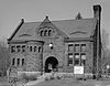
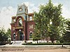
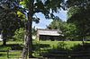
Significant due to its construction, its American paintings and books from its original role as a public library and free art gallery, and its funding by Horace Fairbanks, manufacturer of the world’s first platform scale.
45 St. Johnsbury Federal Fish Culture Station
St. Johnsbury Federal Fish Culture Station StJohnsburyVT FormerFederalFishCultureStation.jpg
St. Johnsbury Federal Fish Culture Station
March 18, 2005
(#05000189)
374 Emerson Falls Rd.
44°25′59″N72°02′15″W / 44.433100°N 72.037584°W / 44.433100; -72.037584 (St. Johnsbury Federal Fish Culture Station)
St. Johnsbury Now houses offices.
46 St. Johnsbury Historic District
St. Johnsbury Historic District Civil War Memorial, St Johnsbury VT.jpg
St. Johnsbury Historic District
April 17, 1980
(#80000424)
U.S. Routes 2 and 5
44°25′06″N72°01′02″W / 44.418333°N 72.017222°W / 44.418333; -72.017222 (St. Johnsbury Historic District)
St. Johnsbury
47 St. Johnsbury Main Street Historic District
St. Johnsbury Main Street Historic District South Congregational Church St. Johnsbury.JPG
St. Johnsbury Main Street Historic District
May 28, 1975
(#75000238)
Area along Main St. including intersecting streets
44°25′06″N72°01′14″W / 44.418333°N 72.020556°W / 44.418333; -72.020556 (St. Johnsbury Main Street Historic District)
St. Johnsbury
48 Stannard Schoolhouse
Stannard Schoolhouse Stannard, Vermont.jpg
Stannard Schoolhouse
December 12, 1977
(#77000097)
Off VT 16
44°32′34″N72°12′52″W / 44.542778°N 72.214444°W / 44.542778; -72.214444 (Stannard Schoolhouse)
Stannard Now the town hall.
49 Stillwater State Park
Stillwater State Park StillwaterStateParkVT RangerStation.jpg
Stillwater State Park
March 29, 2002
(#02000278)
126 Boulder Beach Rd.
44°16′46″N72°16′23″W / 44.279444°N 72.273056°W / 44.279444; -72.273056 (Stillwater State Park)
Groton
50 Thresher Mill
Thresher Mill BarnetVT ThresherMill.jpg
Thresher Mill
April 4, 1996
(#96000386)
W. Barnet Rd., approximately 1.5 mi (2.4 km) west of Barnet
44°18′37″N72°05′51″W / 44.310278°N 72.0975°W / 44.310278; -72.0975 (Thresher Mill)
Barnet
51 Phineas Thurston House
Phineas Thurston House BarnetVT PhineasThurstonHouse1.jpg
Phineas Thurston House
October 30, 1989
(#89001788)
Barnet Town Highway 12
44°21′56″N72°01′29″W / 44.365556°N 72.024722°W / 44.365556; -72.024722 (Phineas Thurston House)
Barnet
52 Toll House
Toll House BurkeVT TollHouse2.jpg
Toll House
August 9, 2006
(#06000704)
2028 Mountain Rd.
44°35′38″N71°54′12″W / 44.593889°N 71.903333°W / 44.593889; -71.903333 (Toll House)
Burke
53 Union Meeting House
Union Meeting House Union Meeting House, Burke, Vermont.jpg
Union Meeting House
January 4, 2008
(#07001345)
2614 Burke Hollow Rd.
44°37′20″N71°56′55″W / 44.622222°N 71.948611°W / 44.622222; -71.948611 (Union Meeting House)
Burke
54 West View Farm
West View Farm WaterfordVT WestViewFarm RoundBarn.jpg
West View Farm
January 6, 1995
(#94001522)
Along Waterford Highway 34
44°24′08″N71°59′33″W / 44.402222°N 71.9925°W / 44.402222; -71.9925 (West View Farm)
Waterford
55 Wheelock Common Historic District
Wheelock Common Historic District WheelockVT TownCommon.jpg
Wheelock Common Historic District
August 30, 2007
(#07000894)
VT 122 and Town Highway 17
44°35′16″N72°04′59″W / 44.5877°N 72.0830°W / 44.5877; -72.0830 (Wheelock Common Historic District)
Wheelock
56 Whitehill House
Whitehill House RyegateVT WhitehillHouse.jpg
Whitehill House
May 30, 1975
(#75000138)
North of Ryegate on Groton-Peacham Rd.
44°15′55″N72°10′27″W / 44.265278°N 72.174167°W / 44.265278; -72.174167 (Whitehill House)
Ryegate
57 Whittier House
Whittier House DanvilleVT WhittierHouse.jpg
Whittier House
August 23, 1984
(#84003456)
Greenbanks Hollow Rd.
44°22′43″N72°07′22″W / 44.378611°N 72.122778°W / 44.378611; -72.122778 (Whittier House)
Danville

See also

Related Research Articles

<span class="mw-page-title-main">National Register of Historic Places listings in Essex County, Massachusetts</span>

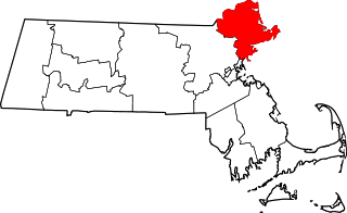
This list is of that portion of the National Register of Historic Places (NRHP) designated in Essex County, Massachusetts. The locations of these properties and districts for which the latitude and longitude coordinates are included below, may be seen in a map.

This is a list of the National Register of Historic Places listings in Addison County, Vermont.

This is a list of the National Register of Historic Places listings in Bennington County, Vermont.

This is a list of the National Register of Historic Places listings in Chittenden County, Vermont.

This is a list of the National Register of Historic Places listings in Rutland County, Vermont.

This is a list of the National Register of Historic Places listings in Orange County, Vermont.

This is a list of the National Register of Historic Places listings in Orleans County, Vermont.

This is a list of the National Register of Historic Places listings in Franklin County, Vermont.

This is a list of the National Register of Historic Places listings in Grand Isle County, Vermont.

This is a list of the National Register of Historic Places listings in Essex County, Vermont.

This is a list of the National Register of Historic Places listings in Lamoille County, Vermont.

This is a list of the National Register of Historic Places listings in Windsor County, Vermont.

This is a list of the National Register of Historic Places listings in Washington County, Vermont.

This is a list of the National Register of Historic Places listings in Windham County, Vermont.

<span class="mw-page-title-main">National Register of Historic Places listings in King George County, Virginia</span>

This is a list of the National Register of Historic Places listings in King George County, Virginia.

<span class="mw-page-title-main">National Register of Historic Places listings in Northampton County, Virginia</span>

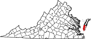
This is a list of the National Register of Historic Places listings in Northampton County, Virginia.

<span class="mw-page-title-main">National Register of Historic Places listings in Uintah County, Utah</span>

This is a list of the National Register of Historic Places listings in Uintah County, Utah.

<span class="mw-page-title-main">National Register of Historic Places listings in Warren County, North Carolina</span>

This list includes properties and districts listed on the National Register of Historic Places in Warren County, North Carolina. Click the "Map of all coordinates" link to the right to view a Google map of all properties and districts with latitude and longitude coordinates in the table below.

This is a complete list of the properties and districts on the National Register of Historic Places in Rocky Mountain National Park, Colorado, United States. The locations of National Register properties and districts for which the latitude and longitude coordinates are included below, may be seen in a Google map.

References

  1. The latitude and longitude information provided in this table was derived originally from the National Register Information System, which has been found to be fairly accurate for about 99% of listings. Some locations in this table may have been corrected to current GPS standards.
  2. National Park Service, United States Department of the Interior, "National Register of Historic Places: Weekly List Actions", retrieved May 26, 2023.
  3. Numbers represent an alphabetical ordering by significant words. Various colorings, defined here, differentiate National Historic Landmarks and historic districts from other NRHP buildings, structures, sites or objects.
  4. "National Register Information System". National Register of Historic Places . National Park Service. April 24, 2008.
  5. The eight-digit number below each date is the number assigned to each location in the National Register Information System database, which can be viewed by clicking the number.
  6. Geocode coordinates derived from NRHP nomination information at HistoricVermont.org.