
Hinckley and Bosworth is a local government district with borough status in south-western Leicestershire, England, administered by Hinckley and Bosworth Borough Council. Its only towns are Hinckley, Earl Shilton and Market Bosworth. Villages include Barwell, Burbage, Stoke Golding, Groby, Shackerstone and Twycross. The population of the Borough at the 2011 census was 105,078.

Ibstock is a town and civil parish about 2.5 miles (4 km) south of Coalville in North West Leicestershire, England. The population of the civil parish was 5,760 at the 2001 census increasing to 6,201 at the 2011 census.

Ellistown Football Club is a football club based in the village of Ellistown, near Coalville in Leicestershire, England. They are currently members of the Leicestershire Senior League Premier Division and play at Terrace Road.

Ibstock United Football Club was a football club based in the village of Ibstock, near Coalville in Leicestershire, England. They played at the Welfare Ground.
Cattybrook Brickpit is a 2.2-hectare (5.4-acre) geological Site of Special Scientific Interest near the village of Almondsbury, South Gloucestershire, notified in 1989. It began as a clay pit and brickworks.

Ellistown is a village about 2 miles (3 km) south of Coalville in North West Leicestershire, England. It is named after Colonel Joseph Joel Ellis who died in 1885. The population from the 2011 census was included in the civil parish of Ellistown and Battleflat.
Ibstock Community College is a middle school with academy status in the village of Ibstock in Leicestershire, England.
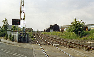
The Leicester–Burton upon Trent line is a freight-only railway line in England linking the Midland Main Line south of Leicester to the Cross Country Route at Burton-on-Trent. The line closed to passengers in the 1960s, since when various proposals have been made to reopen it.

The River Sence is a river which flows in Leicestershire, England. The tributaries of the Sence, including the Saint and Tweed, fan out over much of western Leicestershire from Charnwood Forest and Coalville in the north-east to Hinckley and almost to Watling Street in the south and south-west. Its watershed almost coincides with Hinckley and Bosworth Borough of Leicestershire, which was formed in 1974 by amalgamation of Market Bosworth Rural District and Hinckley Urban District. It flows into the Anker, which in turn flows into the River Tame. It is part of the wider River Trent catchment, which covers much of central England. In 1881, Sebastian Evans wrote that the usual names for this river were Shenton Brook and Sibson Brook.

The A447 is a road in Leicestershire, England, which links traffic from Hinckley to Coalville.

Donington le Heath is a village on the River Sence just over 1 mile (1.6 km) south of the centre of Coalville in North West Leicestershire. Donington is contiguous with the village of Hugglescote immediately to the east. The population of the village is included in the civil parish of Hugglescote and Donington le Heath.

East Sheen Common, also known as Sheen Common, is an area of public open space in East Sheen in the London Borough of Richmond upon Thames. It is adjacent to Richmond Park and separated from it by a brick wall which forms the park's boundary. A gate, Bog Gate, provides pedestrian access between the park and the common. East Sheen Common is owned by The National Trust. It is currently leased to Richmond upon Thames Borough Council.

Ibstock Place School is an independent co-educational day school for pupils aged 4 –18 located in Roehampton, south-west London. It was founded as the Froebel Demonstration School, the name meaning that it was connected with the Froebel Institute and the demonstration of its educational principles. For many years the school educated pupils up to the age of 13. In 1976, however, this was extended to 16 years until the age range extended to 18 years after a sixth form was established in 2005.
National Cycle Route 63 is a route of the National Cycle Network, running from Burton on Trent to Wisbech.
The 2013–14 East Midlands Counties Football League season was the 6th in the history of East Midlands Counties Football League, a football competition in England.
Ibstock plc is a manufacturer of clay bricks and concrete products with operations in the UK. It is listed on the London Stock Exchange and is a constituent of the FTSE 250 Index.
The 2011–12 East Midlands Counties Football League season was the 4th in the history of East Midlands Counties Football League, a football competition in England.

Heather and Ibstock railway station is a disused railway station on the former Ashby and Nuneaton Joint Railway. It served the village of Heather and town of Ibstock. It closed to passengers in 1931 but closed to parcel traffic in 1951. Goods continued to pass through until 1954 when the line was closed from Hugglescote to Shackerstone. The site has since been demolished and is now part of a housing estate which now occupies the entire former station site.
This page is based on this
Wikipedia article Text is available under the
CC BY-SA 4.0 license; additional terms may apply.
Images, videos and audio are available under their respective licenses.


